Kirkby, North Yorkshire
Kirkby (historically known as Kirkby-in-Cleveland) is a village and civil parish in Hambleton district of North Yorkshire, England, near Great Busby and 2 miles (3.2 km) south of Stokesley.[2] The village is mentioned in the Domesday Book as belonging to Uhtred.[3] The name of the village derives from the Old Norse kirkju-býr, which means church with a village.[4] At the 2001 Census, the population of the village was recorded at 313,[5] dropping slightly to 309 at the 2011 Census.[1] In 2015, North Yorkshire County Council estimated the population to be 310.[6]
| Kirkby | |
|---|---|
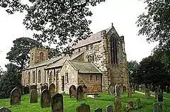
 St Augustine's Church, Kirkby, in 2004 | |
.svg.png.webp) Kirkby Location within North Yorkshire | |
| Population | 309 (2011 census)[1] |
| OS grid reference | NZ538059 |
| Civil parish |
|
| District | |
| Shire county | |
| Region | |
| Country | England |
| Sovereign state | United Kingdom |
| Post town | MIDDLESBROUGH |
| Postcode district | TS9 |
| Police | North Yorkshire |
| Fire | North Yorkshire |
| Ambulance | Yorkshire |
The village used to be served by Stokesley railway station on the Picton to Battersby railway line, which was 1 mile (1.6 km) north of the village.[7] The A172 road is to the north and the B1257 Stokesley to Helmsley road is in the village of Great Broughton, 0.62 miles (1 km) to the east.[8]
The parish church of St Augustine was built in 1815 to replace a medieval building.[9] The chancel was rebuilt in the early 1900s by London architect Temple Moore. It is a grade II* listed building.[10] Besides the church, Kirkby also has a village hall and a public house, the Black Swan.[11]
To the south of the village is Kirby Bank (without a second 'K'). Part of the pathway there is a Medieval greenway known as the Kirby Bank Trod, which is believed to have been laid in the 12th century as part of the route to Rievaulx Abbey. The track is a scheduled ancient monument.[12]
References
- UK Census (2011). "Local Area Report – Kirkby Parish (1170216874)". Nomis. Office for National Statistics. Retrieved 29 April 2018.
- "History of Kirby in Cleveland, in Hambleton and North Riding | Map and description". www.visionofbritain.org.uk. Retrieved 23 January 2020.
- "Kirkby | Domesday Book". opendomesday.org. Retrieved 23 January 2020.
- Ekwall, Eilert (1960). The concise Oxford dictionary of English place-names (4 ed.). Oxford: Oxford University Press. p. 279. ISBN 0-19-869103-3.
- UK Census (2001). "Local Area Report – Kirkby Parish (36UC085)". Nomis. Office for National Statistics. Retrieved 23 January 2020.
- "2015 Population Estimates Parishes" (PDF). northyorks.gov.uk. December 2016. p. 11. Archived from the original (PDF) on 4 June 2022. Retrieved 23 January 2020.
- "Parishes: Kirkby-in-Cleveland | British History Online". www.british-history.ac.uk. Retrieved 23 January 2020.
- "OL26" (Map). North York Moors - Western area. 1:25,000. Explorer. Ordnance Survey. 2016. ISBN 9780319242650.
- "Genuki: Kirkby In Cleveland, Yorkshire (North Riding)". www.genuki.org.uk. Retrieved 23 January 2020.
- Historic England. "CHURCH OF ST AUGUSTINE (1189284)". National Heritage List for England. Retrieved 9 December 2013.
- Barnett, Ben (29 September 2019). "Village Focus: Protecting the peace at Kirkby in Cleveland". The Yorkshire Post. Retrieved 23 January 2020.
- Historic England. "Kirby Bank Trod, a section of paved trackway extending 400m southwards from just east of The Warren (1405913)". National Heritage List for England. Retrieved 23 January 2020.