Kiwitahi
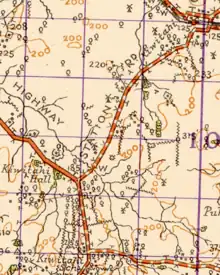
Kiwitahi is a rural community in the Matamata-Piako District and Waikato region of New Zealand's North Island, located directly south of Morrinsville.
The community has a school and a local hall that accommodates up to 120 people.[1]
History
Kiwitahi was occupied by Māori before being converted into farmland by European settlers from the 1870s.[2]
William Chepmell established a 690-acre farm at Kiwitahi in 1871, which he continued operating through the depression of the 1880s and 1890s without having to sell or subdivide. He led a campaign for a road between Morrinsville and Thames and became a politician, serving on the Piako Council and Waitoa Road Board at various times between 1887 and 1914. The remoteness of Kiwitahi meant he rode an estimated 56,000 km to attend council and road board meetings.[3]

In 1985, Chepmell helped fund the construction of an Anglican church. In 1900, he pushed for a school to be built in Kiwitahi despite his own reservations about public education.[3] The school eventually opened thirteen years later.[4]
By 1902 Cyclopedia of New Zealand described Kiwitahi as having "fine grazing farms" and a railway station.[5]
New Zealand Co-operative Dairy Company Ltd had a cheese factory near the railway station,[6] from 1919, until it burnt down on 9 October 1937,[7] by which time it was producing casein.[8]
In 1923 a poll was held to decide on funding road metalling and there were about 40 or 50 settlers.[9]
Chepmell died in 1930. His farm was brought by the Government after World War II, and subdivided for settling returned servicemen back to the land.[3]
Railway station
Kiwitahi had a flag station about 4 mi (6.4 km) from the village, on the East Coast Main Trunk,[5] opened from Morrinsville to Tīrau (then called Oxford) on Monday 8 March 1886[10] by the Thames Valley & Rotorua Railway Co. New Zealand Railways Department took over the line on 1 April 1886.[11] By 1896 Kiwitahi had a 14 ft (4.3 m) by 8 ft (2.4 m) shelter shed, platform, cart approach, loading bank, cattle yards, two cottages and a passing loop for 19 wagons, extended to 34 by 1911 and 53 by 1964.
In 1898 there was a petition for a goods shed and, in 1905, there was a record that a new goods shed had been built at Waitakere and the old one re-erected at Kiwitahi. However, a 1924 report said that a 40 ft (12 m) by 30 ft (9.1 m) shed was about to be built.[12] There was a shed opposite the shelter after the station closed.[13] Sheep yards were added between 1887 and 1911. In 1912 it was noted that a tablet porter required.[11] In the 1930s the porter established a garden at the station.[14] In 1937 the stockyards were extended and electric lights replaced the oil lamps.[15] In 1918 the Returned Services Association got a Post Office opened at the station.[16] It closed in 1947. There was also a store and petrol pump next to the station from 1923 to 1934.[17]
Kiwitahi station closed to passengers on 12 November 1968 and to goods on 17 July 1972.[10] There is now only a single track through the station site.[18] There is a passing loop[19] at Kereone, 3.81 km (2.37 mi) to the south.[20]
Ecology
A water quality, water flow and ecology monitoring station is located at on the Piako River at Kiwitahi. It is open with a one-metre fenced off buffer on either side of the stream and no riparian planting. Macrophytes choke the softy, silty riverbed during the summer, but are often removed during the winter floods.[22]
Education
Kiwitahi School is a co-educational state primary school for Year 1 to 6 students,[23] with a roll of 64 as of April 2023.[24]
The school was established in 1913 and held Golden Jubilee celebrations in 1963.[4]
References
- "Kiwitahi Hall". mpdc.govt.nz. Matamata-Piako District Council.
- Miller, Anne Marygold (1964). Kiwitahi, gem of the Waikato : land of Pakeha and Maori. Morrinsville: Morrinsville Star Print.
- Williams, Lyn (1 June 2018). "History: The dead tell tales". Stuff. Waikato Times.
- Miller, Anne Marygold (1963). Kiwitahi School golden jubilee, 1913-1963; Kiwitahi district, 1869-1963. Morrinsville: East Waikato Publishers.
- Cyclopedia of New Zealand. Christchurch: Cyclopedia Company Limited. 1902.
- "PROGRESSIVE WAIKATO. WAIKATO TIMES". paperspast.natlib.govt.nz. 5 December 1923. Retrieved 21 April 2021.
- "Heritage Trail" (PDF). Matamata Piako District Council. 2008.
- "CASEIN FACTORY BURNED. MATAMATA RECORD". paperspast.natlib.govt.nz. 11 October 1937. Retrieved 21 April 2021.
- "PROGRESSIVE WAIKATO - WAIKATO TIMES". paperspast.natlib.govt.nz. 1 December 1923. Retrieved 12 April 2020.
- Scoble, Juliet (2010). "Names & Opening & Closing Dates of Railway Stations" (PDF). Rail Heritage Trust of New Zealand. Archived from the original (PDF) on 24 July 2020. Retrieved 22 April 2021.
- "Stations" (PDF). NZR Rolling Stock Lists. Archived from the original (PDF) on 8 February 2013. Retrieved 10 August 2020.
- "LOCAL AND GENERAL. TE AROHA NEWS". paperspast.natlib.govt.nz. 23 September 1924. Retrieved 21 April 2021.
- "Kiwitahi Railway Station". Morrinsville Museum. 23 March 2014. Retrieved 21 April 2021.
- "RAILWAY STATION GARDENS. MATAMATA RECORD". paperspast.natlib.govt.nz. 26 November 1936. Retrieved 21 April 2021.
- "Kiwitahi Railway. MATAMATA RECORD". paperspast.natlib.govt.nz. 6 May 1937. Retrieved 21 April 2021.
- "CLOSING A POST OFFICE. NEW ZEALAND HERALD". paperspast.natlib.govt.nz. 22 April 1927. Retrieved 21 April 2021.
- "FIRE AT KIWITAHI. MATAMATA RECORD". paperspast.natlib.govt.nz. 19 July 1934. Retrieved 21 April 2021.
- "Kiwitahi Station Rd". Google Maps. Retrieved 21 April 2021.
- "Kiwitahi Railway Road". Google maps. Retrieved 22 April 2021.
- New Zealand Railway and Tramway Atlas (First ed.). Quail Map Co. 1965. pp. 3 & 4.
- Yonge, John Roger; Company, Quail Map (1993). New Zealand Railway and Tramway Atlas. Quail Map Company. ISBN 9780900609923.
- "Piako River at Kiwitahi". lawa.org.nz. Land Air Water Aotearoa.
- "Ministry of Education School Profile". educationcounts.govt.nz. Ministry of Education.
- "Education Review Office Report". ero.govt.nz. Education Review Office.