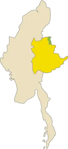
Kokang
Kokang (Burmese: ကိုးကန့်; Chinese: 果敢; pinyin: Guǒgǎn; Wade–Giles: Kuo-kan) is a region in Myanmar. It is located in the northern part of Shan State, with the Salween River to its west, and sharing a border with China's Yunnan Province to the east. Its total land area is around 1,895 square kilometers (732 sq mi).[1] The capital is Laukkai. Kokang is mostly populated by Kokang Chinese, a Han Chinese group living in Myanmar.
Kokang
ကိုးကန့် / 果敢 | |
|---|---|
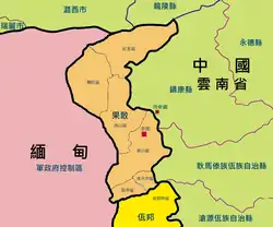 Map of Kokang | |
| Highest point | 2,548 m |
| Area | |
| • Total | 1,895 km2 (732 sq mi) |
| Elevation | 1,000 m (3,000 ft) |
| Population (2009) | |
| • Total | 150,000 |
| • Density | 79/km2 (210/sq mi) |
Kokang had been historically part of China for several centuries and is still claimed by the Republic of China to this day, but was largely left alone by successive governments due to its remote location. The region formed a de facto buffer zone between Yunnan province and the Shan States.[2] The Yang clan, originally Ming loyalists from Nanjing, consolidated the area into a single polity. In 1840, the Yunnan governor granted the Yang clan the hereditary rights as a vassal of the Qing dynasty.[2] After the British conquest of Upper Burma in 1885, Kokang was initially placed in China under the 1894 Sino-British boundary convention. It was ceded to British Burma in a supplementary agreement signed in February 1897.[3]
From the 1960s to 1989, the area was controlled by the Communist Party of Burma, and after the party's armed wing disbanded in 1989 it became a special region of Myanmar under the control of the Myanmar Nationalities Democratic Alliance Army (MNDAA). Armed conflicts between the MNDAA and the Tatmadaw have resulted in the 2009 Kokang incident and the 2015 Kokang offensive.
Etymology
The name Kokang derives from the Burmese ကိုးကန့်, which itself derives from the Shan ၵဝ်ႈ (kāo, "nine") + ၵူၼ်း (kúun, "family") or ၵၢင် (kǎang, "guard").
Demographics
In 2009, the population was reported to be around 150,000.[1] Of these, around 100,000 people held Burmese nationality, the remainder being from China. Of the Burmese nationality, 90% are ethnic Han-Chinese.[4]
History
Chiefdom of Kokang
Yang Xiancai (simplified Chinese: 杨献才; traditional Chinese: 楊獻才; pinyin: Yáng Xiàncái) founded the state Xingdahu (simplified Chinese: 兴达户; traditional Chinese: 興達戶; pinyin: Xīng Dáhù) in 1739 in and around Ta Shwe Htan. The name was changed to Kokang by his successors. In 1840, the Yunnan governor granted the Yang clan the hereditary rights as a Tusi of the Qing dynasty.[2] After the British conquest of Upper Burma in 1885, Kokang was initially placed in China under the 1894 Sino-British boundary convention. It was ceded to British Burma in a supplementary agreement signed in February 1897.[3]
Recent history
After the collapse of the Communist Party of Burma in 1989, Kokang was assigned as the autonomous First Special Region in Shan State. Peng Jiasheng's Myanmar National Democratic Alliance Army took control of the region, and a ceasefire between the group and the Tatmadaw was signed. However, in 2009, the Tatmadaw asked that the group become a border guard under the army's direction. The MNDAA refused, and the armed forces ousted the group and took over the region.[5]
In 2003, a ban on the opium poppy came into effect.[6]
The 2008 Myanmar Constitution defines Kokang is a self-administered zone. Kongyan Township and Laukkai Township aka Laukkaing Township are grouped together to form Kokang Self-Administered Zone, which replaced the "First Special Region".[7]
2009 Kokang conflict
In August 2009, Kokang was the site of a violent conflict, the Kokang incident, between junta forces and various ethnic armies.[8] As a result of the conflict the MNDAA lost control of the area and as many as 30,000 refugees fled to Yunnan province in neighboring China.[9]
2015 Kokang offensive
On 17 February 2015 Myanmar president Thein Sein declared a state of emergency and a three-month period of martial law in Kokang in response to fighting between government troops and the Myanmar National Democratic Alliance Army, a Kokang insurgent group.[10]
See also
References
- "Myanmar fighters cross into China". Al Jazeera News. 30 August 2009. Retrieved 30 August 2009.
- Lintner, Bertil (1999). Burma in Revolt: Opium and Insurgency since 1948. Silkworm Books. p. 48. ISBN 978-1-63041-184-8.
- Kratoska, Paul H. (13 May 2013). Southeast Asian Minorities in the Wartime Japanese Empire. Routledge. p. 40. ISBN 978-1-136-12514-0.
- Li, Xue (20 May 2015). "Can China Untangle the Kokang Knot in Myanmar?". The Diplomat.
- "Myanmar Regional Crime Webs Enjoy Post-Coup Resurgence: The Kokang Story". United States Institute of Peace. Retrieved 2023-09-21.
- Joint Kokang-Wa Humanitarian Needs Assessment Team, Replacing Opium in Kokang and Wa Special Regions (PDF)
- "Myanmar Constitution-Chapter 2 | Amnesty International USA". Amnestyusa.org. Archived from the original on 2011-02-18. Retrieved 2013-11-30.
- Auswärtiges Amt Myanmar Innenpolitik
- 47 Myanmar soldiers reported dead in clashes with Kokang rebels
- Soe Zeya Tun (17 February 2015). "Myanmar declares martial law in troubled Kokang region". Reuters. Retrieved 18 February 2015.