Kolikyogan
The Kolikyogan (Russian: Коликъёган,[1] also Колекъёган, often written Kolik"yegan or Kolik'egan) is a river in the Khanty-Mansi Autonomous Okrug of Russia. It is a right-hand tributary of the westward-flowing Vakh, which it enters from the north. It is 457 kilometres (284 mi) long, and has a drainage basin of 12,200 square kilometres (4,700 sq mi).[2]
| Kolikyogan | |
|---|---|
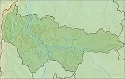 Mouth location in Khanty-Mansi Autonomous Okrug, Russia | |
| Location | |
| Country | Russia |
| Region | Khanty-Mansi Autonomous Okrug |
| Physical characteristics | |
| Source | |
| • location | Siberian Uvaly |
| Mouth | Vakh |
• coordinates | 61.09639°N 78.29444°E |
| Length | 457 km (284 mi) |
| Basin size | 12,200 km2 (4,700 sq mi) |
| Basin features | |
| Progression | Vakh→ Ob→ Kara Sea |
The interfluvial area between the Kolikyogan and Sabun rivers of the west Siberian lowland is a zone of raised string bogs covering 12,885 square kilometres (4,975 sq mi). It is a status B Ramsar wetland, nominated for designation as a Wetland of International Importance in 2000.[3] The river gives its name to the Verkhae-Kolikyogan oilfield, which has estimated ultimate recovery of 160 million cubic metres (1,008 million barrels) oil and of 120 billion cubic metres (4.2 trillion cubic feet) gas.[4]
References
Citations
- Словарь названий гидрографических объектов России и других стран — членов СНГ Archived 2016-03-06 at the Wayback Machine, Federal Service for Geodesy and Cartography of Russia, 1999, p. 187
- "Река КОЛИК ЕГАН in the State Water Register of Russia". textual.ru (in Russian).
- Fraser & Keddy 2005, p. 55.
- Halbouty 2003, p. 84.
Sources
- Fraser, Lauchlan H.; Keddy, Paul A. (2005-06-10). The World's Largest Wetlands: Ecology and Conservation. Cambridge University Press. ISBN 978-0-521-83404-9. Retrieved 2013-03-28.
- Halbouty, Michel Thomas (2003). Giant Oil and Gas Fields of the Decade, 1990-1999. AAPG. p. 84. ISBN 978-0-89181-359-0. Retrieved 29 March 2013.