Kupferschiefer
The Kupferschiefer (German for Copper Shale, also called Copper Slate)[1][2] or Kupfermergel (Copper Marl), (T1 or Z1)[3] is an extensive and remarkable sedimentary unit in Central Europe. The relatively monotonous succession is typically 30 to 60 centimetres (12 to 24 in) and maximum 2 metres (6.6 ft) thick, but extends over an area of 600,000 square kilometres (230,000 sq mi) across the Southern Permian Basin. The Kupferschiefer can be found in outcrop or in the subsurface straddling six countries, including parts of the southern North Sea. The lateral equivalent outcropping in England is called Marl Slate.
| Kupferschiefer | |
|---|---|
| Stratigraphic range: Late Permian | |
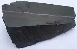
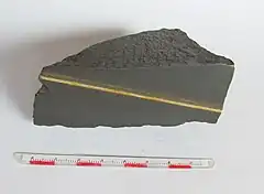 Sample of shale with chalcopyrite vein from the Kupferschiefer | |
| Type | Member |
| Unit of | Werra Formation |
| Underlies | Zechstein Limestone |
| Overlies | Rotliegend Group |
| Area | 600,000 km2 (230,000 sq mi) |
| Thickness | Typically 30 to 60 centimetres (12 to 24 in) Max. 2 m (6.6 ft) |
| Lithology | |
| Primary | Black shale, marl |
| Other | Mudstone, limestone, copper, zinc, lead, silver, gold, platinum |
| Location | |
| Coordinates | 51.0°N 10.0°E |
| Approximate paleocoordinates | 15.3°N 22.6°E |
| Region | North-central Europe |
| Country | |
| Extent | Southern Permian Basin |
| Type section | |
| Named for | "Kupfer" = copper, "Schiefer" = shale |
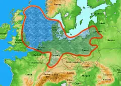 Extent of the Zechstein sea, where the Kupferschiefer was deposited | |
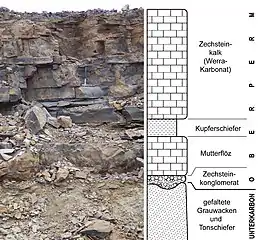
Despite its distinctive nature, the Kupferschiefer is not ranked as a formation but is officially declared a sub-unit of the Werra Formation, the lowest formation of the Zechstein Group, overlying the Rotliegend Group. The unit has been dated to 257.3 ± 1.6 Ma, placing it in the Wuchiapingian stage of the Late Permian.
The Kupferschiefer comprises black shales, bituminous marls, mudstones and limestones deposited mostly in an open marine setting, with the borders of its extension deposited in a shallow marine environment. At time of deposition, the area what is now northern Europe was covered by an enclosed sea; the Zechstein sea, characterized by anoxic conditions.
The Kupferschiefer is renowned for hosting one of the most important copper deposits in the world, which were mined at least since 1199 AD. Other mineral resources found in the unit include zinc, vanadium, lead and silver.
The Kupferschiefer is also an important lagerstätte; having provided fossils of early Archosauromorph reptiles, the ancestors to modern crocodiles and extinct dinosaurs, as well as pareiasaurs, many fossil fish, including Coelacanthus granulatus, Dorypterus hoffmanni and Palaeoniscum freieslebeni, flora and other fossils. Famous finds from the unit include Parasaurus geinitzi, Protorosaurus speneri, Weigeltisaurus jaekeli and Glaurung schneideri.
Description
The Kupferschiefer is a regional stratigraphic unit stretching across an area of 600,000 square kilometres (230,000 sq mi) in the Southern Permian Basin of north-central Europe. The unit is typically 30 to 60 centimetres (12 to 24 in) thick. In the Rossenray 2 shaft, the unit reaches a maximum thickness of 2 metres (6.6 ft).[4] The Kupferschiefer unconformably overlies various formations of the Rotliegend Group and the Varsican basement and forms the basal unit of the Zechstein Group.[5] In some parts of the Zechstein Basin, the Kupferschiefer is underlain by the Mutterflöz Limestone, an organic-lean thin limestone unit.[6] Despite its distinctive nature, the Kupferschiefer is not ranked as a formation but is officially declared a sub-unit of the Werra Formation, the lowest formation of the Zechstein Group. The Kupferschiefer is overlain by the Zechstein Limestone sub-unit of the Werra Formation.[3]
The unit has been dated to 257.3 ± 1.6 Ma, placing it in the Wuchiapingian stage of the Late Permian.[7] The age of the unit corresponds to the Ilinskoe part of the Sokolki Assemblage Zone of European Russia and the Tropidostoma Assemblage Zone of the Karoo Basin of South Africa.[8]
The Kupferschiefer contains up to 30% organic matter,[9] with variations across its extent. The basinal facies shows values of between 5 and 25% TOC, while the marginal facies present values up to 7% TOC and swell facies are much poorer in organic matter with values below 1%.[6]
Basin history
Depositional environment
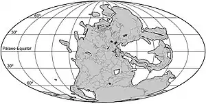
The Kupferschiefer was deposited in a highstand setting,[3] in a deep enclosed basin, covered by the Zechstein sea that was present on the paleocontinent Laurussia, the northern part of Pangea.[10] The basin possibly had periodic connections to the Paleo-Tethys Ocean.[11] Sedimentation rates during Kupferschiefer deposition were low, estimated at 5 millimetres (0.20 in) per thousand years.[12]
The climate of the Late Permian was extremely variable, with polar icecaps present near the south pole and hot and arid conditions prevailing in the tropic and paleotemperate regions of the northern and southern hemispheres.[13] The Zechstein sea in the Late Permian was located at paleolatitudes around 15 to 16 degrees north.[14] Large areas of Pangea were covered by deserts and arid conditions also prevailed near the Zechstein sea of the time.[15]
Apatite oxygen isotope analysis has revealed that the Late Permian was characterized by a drastic increase in global temperatures, accompanied by a strong rise of eustatic sea level. The rise in oxygen isotope values was possibly related to an increase in volcanic activity.[16] The Permian-Triassic extinction event, the biggest extinction event in geologic history, is thought to have been caused mostly by large volcanic provinces of the Siberian Traps.
Mining
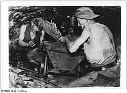
Prehistoric finds of slag and bronze from smelting sites on top of or immediately adjacent to outcropping Kupferschiefer ores at Wettelrode, Mohrungen, and Bottendorf in Central Germany evidence Early to Middle Bronze Age mining of the Kupferschiefer ores. The medieval mining history of the Kupferschiefer ores is documented in written sources since at least 1199 A.D. from the Mansfeld district in Central Germany. The Counts of Mansfeld developed several copper mines, smelters, and a mint at the town of Eisleben, where copper and silver coins were minted from the metals of the Kupferschiefer ores.[17]
Germany
The main mining district of the Kupferschiefer in Germany was Mansfeld Land, which operated from at least 1199 AD,[18] and has provided 2,009,800 tonnes of copper and 11,111 tonnes of silver.[19] The Mansfeld mining district was exhausted in 1990.[18][20]
Eisleben in the Mansfeld Land is the type locality of two minerals;[21] the nickel-arsenate maucherite,[22] and betekhtinite, a copper-lead-iron sulfide.[23] The latter mineral has a co-type locality in the Ernst-Thälmann shaft, that operated from 1906 to 1962 and produced 260,000 tons of copper; about 10% of the overall production from the Mansfeld area.[24]
Many minerals have been found in the Sangerhausen district of Saxony-Anhalt,[1][2] which produced 619,200 tonnes of copper and 3,102 tonnes of silver as of 2012, with 860,000; respectively 4,650 tonnes as remaining proven reserves.[19]
In the Spremberg-Graustein-Schleife mining area, stretching across the Brandenburg district Spree-Neiße and Görlitz in Saxony, the Kupferschiefer is estimated to contain 130 million tonnes of ore, of which 1,486,000 tonnes of copper,[19] with a copper content of 1.47%. The mining district is about 15 by 3 kilometres (9.3 mi × 1.9 mi) and the copper-bearing beds lie at a depth between 980 and 1,580 metres (3,220 and 5,180 ft).[25]
The Kupferschiefer contains up to 3% copper, 10 ppm of platina and up to 3000 ppm gold.[9]
The "Im Lochborn" mine, mining from the Kupferschiefer,[26] located in Bieber, Hessen is the type locality of the mineral bieberite,[27] a cobalt sulfate named after the location.[28] The mineral rösslerite, a magnesium arsenate, also has the mine as type locality.[29]
Poland
Two main Kupferschiefer mining areas in Poland are the North-Sudetic trough, with 212,894 tonnes of copper and 756.7 tonnes of silver mined as of 2012 and an estimated remaining reserves of 1,460,000 tonnes of copper, and the Fore-Sudetic monocline, with more than 20,000,000 tonnes of copper and more than 14,085 tonnes of silver mined since 1949. Main mining districts in Poland are the Głogów industrial district, the Lubichów and Grodziec fields, and the Konrad, Lena, Lubin, Nowy Kosciół, Polkowice, Rudna and Sieroszowice mines.[19] The latter mine[30] is the type locality for the silver-quicksilver amalgame, eugenite.[31] The Polkowice mine is the type locality for two rare lead and germanium-bearing sulfide minerals;[32] polkovicite, named after the mine,[33] and morozeviczite.[34]
Paleontological significance
The Kupferschiefer has provided unique fossils of an early reptile; Protorosaurus speneri belonging to the Archosauromorpha, as well as Pareiasauria, fish, an insect and fossil flora.
As of 2014, at least 28 Protorosaurus speneri specimens are known from the Kupferschiefer in the states of Thuringia and Hesse in central Germany.[35] The type locality for the species is Glücksbrunn, Heidelberg, near Schweina in Thuringia.[14][36] The type locality for Parasaurus geinitzi is Walkenried in Lower Saxony.[37][38] Fossils of both species were found containing quartz pebbles in their guts.[39][40]
Fossil fish of the species Palaeoniscum freieslebeni are abundantly found in different locations in the Kupferschiefer. The species epithet of the "Eisleben Shale Fish", or "Kupferschiefer Herring" refers to Johann Karl Freiesleben, the Berghauptmann (mining inspection director) of Saxony.[41] Other fish found in the Kupferschiefer include Coelacanthus granulatus, Hopleacanthus richelsdorfensis, Acentrophorus glaphyurus, Menaspis armata, Muensterichthys buergeri, Platysomus striatus, and two species of Janassa and Wodnika.
Fossil content
| Group | Fossils | Image | Notes |
|---|---|---|---|
| Archosauromorpha | Protorosaurus speneri | 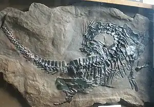 | [35] |
| Weigeltisauridae | Weigeltisaurus jaekeli | 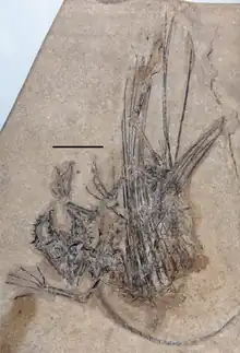 | [42] |
| Glaurung schneideri | [43] | ||
| Pareiasauria | Parasaurus geinitzi | [37] | |
| Fish | Palaeoniscum freieslebeni | 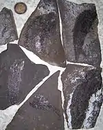 | [9] |
 | |||
 | |||
| Coelacanthus granulatus |  | [44] | |
| Hopleacanthus richelsdorfensis | 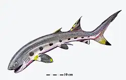 | [45] | |
| Janassa bituminosa, J. korni | 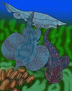 | [46][47][48] | |
| Menaspis armata | [49] | ||
| Wodnika althausi, W. striatula | 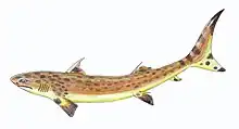 | [44] | |
| Acentrophorus glaphyurus | [50] | ||
| Dorypterus hoffmanni | [44] | ||
| Eurysomus macrurus | [44] | ||
| Globulodus elegans | [44] | ||
| Muensterichthys buergeri | [51] | ||
| Platysomus striatus | [52] | ||
| Pygopterus humboldti | [44] | ||
| Reticulolepis exsculpta | [44] | ||
| Acrolepis sp. | [53] | ||
| Ctenacanthus richelsdorfensis | [4][54] | ||
| Insects | Protereisma rossenrayensis | [55][56] | |
| Nautiloids | Peripetoceras freieslebeni | [52] | |
| Pteronautilus seebachianus | [50] | ||
| Bivalves | Aviculopinna prisca | [57] | |
| Bakevellia sp. | [50] | ||
| Macroflora | Neocalamites mansfeldicus | [4] | |
| Sphenobaiera digitata | 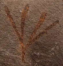 | [4] | |
| Baiera mansfeldensis | [58] | ||
| Esterella gracilis | [59] | ||
| Bhenania reichelti, Calipteris martinsi, Pseudovoltzia liebeana, Quadrocladus orobiformis, Q. solmsi, Sphenopteris kukukiana, Ullmannia bronni, U. frumentaria | [4] | ||
| Pollen | Crustaesporites globosus, Illenites cf. bentzi, I. cf. unicus, Jugasporites delasaucei delasaucei, J. delasaucei moersensis, Lueckisporites richteri, L. virkkiae, Nuskoisporites dulhuntyi, Pityosporites granulatus, P. schaubergeri, P. zapfei, Platysaccus papilionis | [60][61] | |
Geologic maps
Zechstein in blue
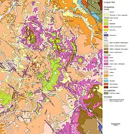 Rhoen
Rhoen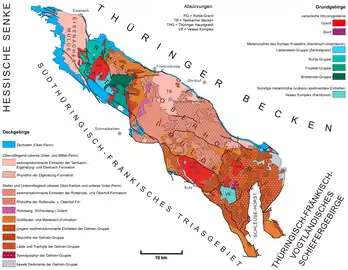 Thuringian Forest
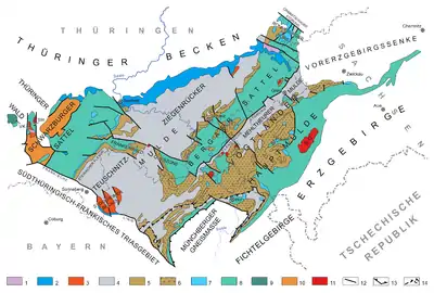 Thuringian-Franconian mountains
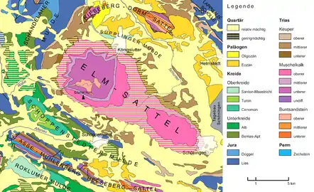 Eastern Brunswick
See also
- List of fossiliferous stratigraphic units in Denmark
- List of fossiliferous stratigraphic units in Germany
- List of fossiliferous stratigraphic units in the Netherlands
- List of fossiliferous stratigraphic units in Poland
- Rio do Rasto Formation, contemporaneous fossiliferous formation of the Paraná Basin, Brazil
- Copperfields Mine of Canada
- Copper Country of Michigan
- Chuquicamata of Chile
- Copperbelt Province of Zambia
- Old Adaminaby and Lake Eucumbene of Australia
References
- Copper slate deposits, Sangerhausen at Mindat.org
- Bernard Koenen shafts I and II, Copper slate deposits, Sangerhausen at Mindat.org
- Paleo-ecosystems, p.4
- Bachmayer & Malzahn, 1983, p.101
- Paleo-ecosystems, p.2
- Paleo-ecosystems, p.22
- Ezcurra et al., 2014b
- Tsuji & Müller, 2008, p.1112
- (in German) Drama im Kupferschiefermeer
- Paleo-ecosystems, p.7
- Paleo-ecosystems, p.6
- Schwarzer Philipp at Fossilworks.org
- Paleo-ecosystems, p.9
- Glücksbrunn/Heidelberg near Schweina at Fossilworks.org
- Paleo-ecosystems, p.10
- Paleo-ecosystems, p.11
- Borg et al., 2012, p.457
- Borg et al., 2012, p.455
- Borg et al., 2012, p.458
- Borg et al., 2012, p.475
- Eisleben, Mansfeld at Mindat.org
- Maucherite at Mindat.org
- Betekhtinite at Mindat.org
- Ernst-Thälmann shaft, Mansfeld at Mindat.org
- (in German) KSL Kupferschiefer Lausitz GmbH
- Borg et al., 2012, p.456
- "Im Lochborn" mine, Bieber, Hessen at Mindat.org
- Bieberite at Mindat.org
- Rösslerite at Mindat.org
- Sieroszowice mine at Mindat.org
- Eugenite at Mindat.org
- Polkowice mine at Mindat.org
- Polkovicite at Mindat.org
- Morozeviczite at Mindat.org
- Ezcurra et al., 2014a, p.7
- Ezcurra, 2016, p.22
- Tsuji & Müller, 2008
- Walkenried at Fossilworks.org
- Munk & Kues, 1993, p.171
- Munk & Kues, 1993, p.172
- (in German) Palaeoniscum freieslebeni at Museum Schloss Bernburg
- Weichelt, 1930
- Bulanov & Sennikov, 2015, p.1357
- Richelsdorf (Althaus collection) at Fossilworks.org
- Wolfsberg pit at Fossilworks.org
- Mansfeld, Dresden collection at Fossilworks.org
- Freieslebenschacht at Fossilworks.org
- Brandt, 2009, p.16
- Lonau at Fossilworks.org
- Hasbergen Excavation Planum II at Fossilworks.org
- Bodental at Fossilworks.org
- Hasbergen Excavation Planum I at Fossilworks.org
- Hasbergen Excavation Planum III at Fossilworks.org
- Richelsdorf Mountains at Fossilworks.org
- Guthörl, 1965, p.229
- Rossenray 2 Shaft, 415 m depth, Kamp-Lintfort at Fossilworks.org
- Merzenberg, near Milbitz at Fossilworks.org
- Bauer et al., 2013, p.546
- Bauer et al., 2013, p.549
- Grebe, 1957
- Kupferschiefer 450 m floor Friedrich Heinrich Mine Kamp-Lintfort Germany at Fossilworks.org
Bibliography
- Geology
- Borg, Gregor; Adam Piestrzyński; Gerhard H. Bachmann; Wilhelm Püttmann; Sabine Walther, and Marco Fiedler. 2012. An Overview of the European Kupferschiefer Deposits. Society of Economic Geologists, Inc. Special Publication 16. 455–486. Accessed 2019-03-14.
- Jowett, E. Craig. 1986. Genesis of Kupferschiefer Cu-Ag Deposits by Convective Flow of Rotliegende Brines during Triassic Rifting. Economic Geology 81. 1823–1837. Accessed 2019-03-14.
- Wagner, Thomas; Martin Okrusch; Stefan Weyer; Joachim Lorenz; Yann Lahaye; Heiner Taubald, and Ralf T. Schmit. 2010. The role of the Kupferschiefer in the formation of hydrothermal base metal mineralization in the Spessart ore district, Germany: insight from detailed sulfur isotope studies. Miner Deposita 45. 217–239. Accessed 2019-03-14.
- Zientek, Michael L.; Sławomir Oszczepalski; Heather L. Parks; James D. Bliss; Gregor Borg; Stephen E. Box; Paul D. Denning; Timothy S. Hayes, and Volker Spieth and Cliff D. Taylor. 2015. Assessment of Undiscovered Copper Resources Associated with the Permian Kupferschiefer, Southern Permian Basin, Europe, 1–95. USGS. Accessed 2019-03-14.
- N., N. s.a. Paleo-ecosystems: upper Permian Kupferschiefer, 1–73. Christian-Albrechts-Universität zu Kiel. Accessed 2019-03-14.
- Paleontology
- Bachmayer, Friedrich, and Erich Malzahn. 1983. Der erste Nachweis eines decapoden Krebses im niederrheinischen Kupferschiefer. Ann. Naturhist. Mus. Wien 85. 99–106. Accessed 2019-03-14.
- Bauer, Kathleen; Evelyn Kustatscher, and Michael Krings. 2013. The ginkgophytes from the German Kupferschiefer (Permian), with considerations on the taxonomic history and use of Baiera and Sphenobaiera. Bulletin of Geosciences 88. 539–556. Accessed 2019-03-14.
- Brandt, Silvio. 2009. Über Neufunde von Janassa korni (WEIGELT), einen petalodonten Elasmobranchier aus dem Kupferschiefer (Ober-Perm) von Eisle - ben und Sangerhausen (Sachsen-Anhalt) (About new finds and informations of the petalodontid Janassa korni from the Kupferschiefer (Upper Permian) of Eisleben and Sangerhausen, Germany). Veröffentlichungen Naturhist. Museum Schleusingen 24. 15–26. Accessed 2019-03-14.
- Bulanov, V. V., and A. G. Sennikov. 2015. Glaurung schneideri gen. et sp. nov., a new weigeltisaurid (Reptilia) from the Kupfershiefer (sic) (Upper Permian) of Germany. Paleontological Journal 49(12). 1353–1364. Accessed 2019-03-14.
- Diedrich, C.G. 2009. A coelacanthid-rich site at Hasbergen (NW Germany): taphonomy and palaeoenvironment of a first systematic excavation in the Kupferschiefer (Upper Permian, Lopingian). Palaeobiodiversity and Palaeoenvironments 89. 67–94. Accessed 2019-03-14.
- Ezcurra, Martín D. 2016. The phylogenetic relationships of basal archosauromorphs, with an emphasis on the systematics of proterosuchian archosauriforms. PeerJ 4e1778. 1–385. Accessed 2019-03-14. Archived 2017-12-02 at the Wayback Machine
- Ezcurra, Martín D.; Torsten M. Scheyer, and Richard J. Butler. 2014a. The Origin and Early Evolution of Sauria: Reassessing the Permian Saurian Fossil Record and the Timing of the Crocodile-Lizard Divergence. PLoS ONE 9. 1–36. Accessed 2019-03-14.
- Ezcurra, Martín D.; Torsten M. Scheyer, and Richard J. Butler. 2014b. Correction: The Origin and Early Evolution of Sauria: Reassessing the Permian Saurian Fossil Record and the Timing of the Crocodile-Lizard Divergence. PLoS ONE 9. 1. Accessed 2019-03-14.
- Grebe, H. 1957. Zur Mikroflora des niederrheinischen Zechsteins. Geologisches Jahrbuch 73. 51–74. .
- Guthörl, P. 1965. Zur Arthropoden-Fauna des Karbons und Perms. 21. Protereisma rossenrayensis n. sp., ein Ephemeropteren-Fund (Insecta) aus dem niederrheinischen Zechstein. Paläontologische Zeitschrift 39. 229–233. Accessed 2019-03-14.
- Munk, W., and H.-P. Sues. 1993. Gut contents of Parasaurus (Pareiasauria) and Protorosaurus (Archosauromorpha) from the Kupferschiefer (Upper Permian) of Hessen, Germany. Paläontologische Zeitschrift 67. 169–176. Accessed 2019-03-14.
- Tsuji, L.A., and J. Müller. 2008. A Re-evaluation of Parasaurus geinitzi, the first named pareiasaur (Amniota, Parareptilia). Canadian Journal of Earth Sciences 45. 1111–1121. Accessed 2019-03-14.
External links
- (in German) Images of Palaeoniscum freieslebeni from the Kupferschiefer
- (in German) Kupferschiefer.de
