Kur-Araz Lowland
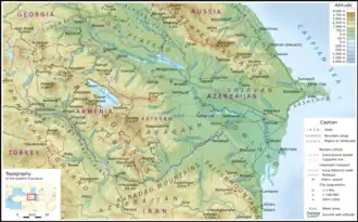
The Kura-Aras Lowland, Kura-Aras Depression or Kura-Aras Basin[1] (Azerbaijani: Kür-Araz ovalığı) is a vast depression in central-southern Azerbaijan defined by the valleys of the Kura River and Aras River. It is situated by the West shore of the Caspian Sea and is part of the Aral-Caspian Depression. It is delimited by the Greater Caucasus from the North, Lesser Caucasus from the West and the Talysh Mountains from the South.[2] The name is derived from the names of the two rivers in the area: the Kura and the Aras.[3]

Topographic map of Armenia and Azerbaijan, Kura-Aras Lowland stretching from Northwest to Southeast.

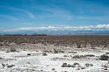
Kur-Araz
See also
- Kura–Araxes culture or Kur–Araz culture, Bronze Age culture from the region
- Trans-Caucasus
References
- The name of Aras may also be variously transliterates as Araz, Arax, or Araxes.
- Profile of Azerbaijan Archived 2011-06-06 at the Wayback Machine, a 2003 World Bank document
- "Azerbaijan - History, People, & Facts". britannica.com. Archived from the original on 10 March 2018. Retrieved 24 April 2018.
Further reading
- Akif A. Alizadeh, Ibrahim S. Guliyev, Fakhraddin A. Kadirov, Lev V. Eppelbaum (Jun 17, 2016). Geosciences of Azerbaijan. Springer. p. 17. ISBN 978-3-319-27395-2.
{{cite book}}: CS1 maint: multiple names: authors list (link)
This article is issued from Wikipedia. The text is licensed under Creative Commons - Attribution - Sharealike. Additional terms may apply for the media files.