Kyiv Peninsula
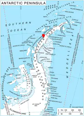
Kyiv Peninsula (Ukrainian: півострів Київ, IPA: [piˈwɔstriu̯ ˈkɪjiu̯]) is the predominantly ice-covered, oval shaped peninsula projecting 35 km in northwest direction from the west side of Graham Land, Antarctic Peninsula. It is bounded by Flandres Bay to the northeast and Beascochea Bay to the southwest, and separated from Wilhelm Archipelago to the northwest by Lemaire Channel and Penola Strait. The peninsula's north extremity Cape Renard divides Graham Coast to the southwest from Danco Coast to the northeast. Mount Demaria is found on the west coast of the peninsula.[1]
Etymology
The feature was first described and named in 2010 by the Antarctic Place-names Commission of Bulgaria after the capital city of Ukraine, in connection with the Ukrainian Antarctic base Vernadsky situated on nearby Galindez Island. The original naming was done in Bulgarian (Bulgarian: полуостров Киев, romanized: poluostrov Kiev, IPA: [poɫuˈɔstrof ˈkɪɛf]).[2][3][4] Later, the name was adopted also by Ukraine in 2020 and translated Kyiv Peninsula.[5][6][7]
Location
Kyiv Peninsula is centred at 65°15′00″S 63°41′00″W. British mapping in 1976.
Maps
- British Antarctic Territory. Scale 1:200000 topographic map. DOS 610 Series, Sheet W 65 62. Directorate of Overseas Surveys, Tolworth, UK, 1976
- Brabant Island to Argentine Islands. Scale 1:250000 topographic map. British Antarctic Survey, 2008
- Antarctic Digital Database (ADD). Scale 1:250000 topographic map of Antarctica. Scientific Committee on Antarctic Research (SCAR). Since 1993, regularly upgraded and updated
Notes
-
 This article incorporates public domain material from "Demaria, Mount". Geographic Names Information System. United States Geological Survey.
 - Bulgarian Antarctic Gazetteer. Antarctic Place-names Commission (in Bulgarian)
- Kiev Peninsula. SCAR Composite Gazetteer of Antarctica
- L. Ivanov and N. Ivanova. Antarctic: Nature, History, Utilization, Geographic Names and Bulgarian Participation. Sofia: Manfred Wörner Foundation, 2014. p. 292. (in Bulgarian)
- Kyiv Peninsula. SCAR Composite Gazetteer of Antarctica
- Bulgarian Antarctic Gazetteer. Antarctic Place-names Commission. (in Bulgarian)
- Kyiv Peninsula. SCAR Composite Gazetteer of Antarctica
References
- Bulgarian Antarctic Gazetteer. Antarctic Place-names Commission. (details in Bulgarian, basic data in English)
- Kyiv Peninsula. SCAR Composite Gazetteer of Antarctica
- Kyiv Peninsula. SCAR Composite Gazetteer of Antarctica
External links
- Kyiv Peninsula. Adjusted Copernix satellite image
This article includes information from the Antarctic Place-names Commission of Bulgaria which is used with permission.