Lac-Nilgaut
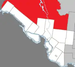
Lac-Nilgaut is a large unorganized territory in the Outaouais region, Quebec, Canada. With a surface area of 9,851 km2 (3,803 sq mi), it makes up over 70% of the northern portion of Pontiac Regional County Municipality.
Lac-Nilgaut | |
|---|---|
 Location within Pontiac RCM | |
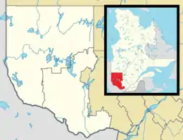
 Lac-Nilgaut Location in western Quebec | |
| Coordinates: 46°36′N 77°15′W[1] | |
| Country | Canada |
| Province | Quebec |
| Region | Outaouais |
| RCM | Pontiac |
| Constituted | January 1, 1986 |
| Government | |
| • Federal riding | Pontiac |
| • Prov. riding | Pontiac |
| Area | |
| • Total | 9,875.70 km2 (3,813.03 sq mi) |
| • Land | 8,966.53 km2 (3,462.00 sq mi) |
| Population (2021)[3] | |
| • Total | 5 |
| • Density | 0.0/km2 (0/sq mi) |
| Time zone | UTC−05:00 (EST) |
| • Summer (DST) | UTC−04:00 (EDT) |
| Postal Code | J0X |
The eponymous Lake Nilgaut is located roughly in the centre of the territory, at an altitude of over 300 metres (980 ft). This 9 kilometres (5.6 mi) long lake is named after the nilgai (French: nilgaut), the largest Asian antelope and only found on the Indian subcontinent. The name was officially introduced in 1935, but it is unknown why this term was chosen to replace the original name Lac à l'Orignal (Moose Lake).[4]
Lake Nilgaut drains via the Nilgaut creek into the Noire River,[4] a major river that, together with the Coulonge River, bisects the territory.
Demographics
|
| |||||||||||||||||||||||||||
| Source: Statistics Canada[5] | ||||||||||||||||||||||||||||

References
- "Reference number 149853 in Banque de noms de lieux du Québec". toponymie.gouv.qc.ca (in French). Commission de toponymie du Québec.
- "Geographic code 84902 in the official Répertoire des municipalités". www.mamh.gouv.qc.ca (in French). Ministère des Affaires municipales et de l'Habitation.
- "Lac-Nilgaut, Unorganized (NO) Census Profile, 2021 Census of Population". www12.statcan.gc.ca. Government of Canada - Statistics Canada. Retrieved 10 November 2022.
- "Lac Nilgaut" (in French). Commission de toponymie du Québec. Retrieved 2019-11-06.
- 1996, 2001, 2006, 2011 census