Lamas de Mouro
Lamas de Mouro is a former civil parish in the municipality of Melgaço in the Viana do Castelo District, Portugal. In 2013, the parish merged into the new parish Castro Laboreiro e Lamas de Mouro.[1] It has a population of 148 inhabitants and a total area of 17.31 km2.[2] [3]
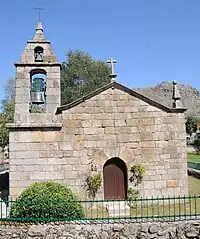
Lamas de Mouro Church
Lamas de Mouro | |
|---|---|
 | |
| Coordinates: 42°03′04″N 8°11′58″W | |
| Country | |
| Region | Norte |
| Intermunic. comm. | Alto Minho |
| District | Viana do Castelo |
| Municipality | Melgaço |
| Disbanded | 2013 |
| Area | |
| • Total | 17.31 km2 (6.68 sq mi) |
| Population | |
| • Total | 148 |
| • Density | 8.5/km2 (22/sq mi) |
| Time zone | UTC±00:00 (WET) |
| • Summer (DST) | UTC+01:00 (WEST) |
Climate
Lamas de Mouro has a cool Mediterranean climate with significant oceanic influences. On average, it has the coldest summer nights out of any populated place in Portugal. Precipitation is high, averaging around 1,650 mm (65 in) per year.
| Climate data for Lamas de Mouro, 1980-1990, altitude 880 m (2,890 ft) | |||||||||||||
|---|---|---|---|---|---|---|---|---|---|---|---|---|---|
| Month | Jan | Feb | Mar | Apr | May | Jun | Jul | Aug | Sep | Oct | Nov | Dec | Year |
| Average high °C (°F) | 9.1 (48.4) |
9.3 (48.7) |
11.8 (53.2) |
12.5 (54.5) |
14.8 (58.6) |
19.3 (66.7) |
22.1 (71.8) |
22.2 (72.0) |
21.5 (70.7) |
16.1 (61.0) |
12.3 (54.1) |
10.3 (50.5) |
15.1 (59.2) |
| Daily mean °C (°F) | 4.1 (39.4) |
4.7 (40.5) |
6.5 (43.7) |
7.5 (45.5) |
9.5 (49.1) |
13.4 (56.1) |
15.5 (59.9) |
15.4 (59.7) |
14.4 (57.9) |
10.6 (51.1) |
7.8 (46.0) |
5.7 (42.3) |
9.6 (49.3) |
| Average low °C (°F) | −0.9 (30.4) |
0.2 (32.4) |
1.1 (34.0) |
2.5 (36.5) |
4.3 (39.7) |
7.6 (45.7) |
9.1 (48.4) |
8.5 (47.3) |
7.4 (45.3) |
5.1 (41.2) |
3.3 (37.9) |
0.9 (33.6) |
4.1 (39.4) |
| Average precipitation mm (inches) | 228 (9.0) |
200 (7.9) |
161 (6.3) |
122 (4.8) |
124 (4.9) |
58 (2.3) |
26 (1.0) |
38 (1.5) |
90 (3.5) |
168 (6.6) |
204 (8.0) |
231 (9.1) |
1,650 (64.9) |
| Mean monthly sunshine hours | 86 | 87 | 155 | 137 | 175 | 218 | 260 | 259 | 216 | 143 | 76 | 78 | 1,890 |
| Source: IPMA[4] | |||||||||||||
References
- Diário da República. "Law nr. 11-A/2013, page 552 70" (pdf) (in Portuguese). Retrieved 28 July 2014.
- "Câmara Municipal de Melgaço". Archived from the original on 2014-12-09. Retrieved 2015-01-03.
- Demographics of Melgaço Archived 2011-07-18 at the Wayback Machine
- "Plano de Gestão da Região hidrográfica do Minho e Lima" (PDF). APA. pp. 103, 115, 119. Retrieved 25 June 2021.
This article is issued from Wikipedia. The text is licensed under Creative Commons - Attribution - Sharealike. Additional terms may apply for the media files.