Hildburghausen (district)
Hildburghausen is a district in Thuringia, Germany. It is bounded by (from the west and clockwise) the district of Schmalkalden-Meiningen, the city of Suhl, the districts of Ilm-Kreis, Saalfeld-Rudolstadt and Sonneberg, and the state of Bavaria (districts of Coburg, Haßberge and Rhön-Grabfeld). Located roughly halfway between the mountain chains of the Rhön and the Thuringian Forest, the district is densely forested and covered by hilly countryside. Its territory is similar to that of the former Ernestine duchy, Saxe-Hildburghausen.
Hildburghausen | |
|---|---|
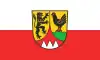 Flag 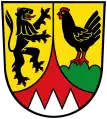 Coat of arms | |
| Country | Germany |
| State | Thuringia |
| Capital | Hildburghausen |
| Government | |
| • District admin. | Thomas Müller (CDU) |
| Area | |
| • Total | 938.42 km2 (362.33 sq mi) |
| Population (31 December 2021)[1] | |
| • Total | 62,089 |
| • Density | 66/km2 (170/sq mi) |
| Time zone | UTC+01:00 (CET) |
| • Summer (DST) | UTC+02:00 (CEST) |
| Vehicle registration | HBN |
| Website | www.landkreis-hildburghausen.de |
Towns and municipalities
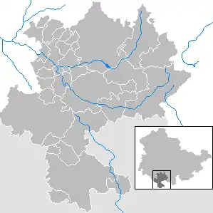
Clickable map of towns and municipalities in the district
| Verwaltungsgemeinschaft (community of administration): free towns and municipalities | |
|---|---|
| Verwaltungsgemeinschaften (community of administration) | ||
|---|---|---|
|
1. Feldstein |
||
| 1seat of the Verwaltungsgemeinschaft;2town | ||
Coat of arms
The coat of arms displays:
- the heraldic lion of Meißen, the precursor state to Saxony
- the cock representing the counts of Henneberg, who ruled the region until 1583
- below the symbol of the bishopric of Würzburg is displayed
References
External links
- (in German) Official website
Wikimedia Commons has media related to Landkreis Hildburghausen.
| Urban districts | |
|---|---|
| Rural districts | |
This article is issued from Wikipedia. The text is licensed under Creative Commons - Attribution - Sharealike. Additional terms may apply for the media files.