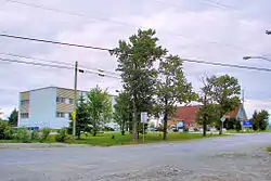
Landrienne
Landrienne is a township municipality in the Canadian province of Quebec, located in the Abitibi Regional County Municipality. It is part of the census agglomeration of Amos.
Landrienne | |
|---|---|
 | |
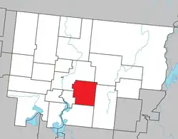 Location within Abitibi RCM | |
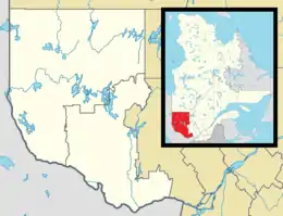 Landrienne Location in western Quebec | |
| Coordinates: 48°33′N 77°57′W[1] | |
| Country | Canada |
| Province | Quebec |
| Region | Abitibi-Témiscamingue |
| RCM | Abitibi |
| Settled | 1910s |
| Constituted | July 15, 1918 |
| Government | |
| • Mayor | Guy Baril |
| • Federal riding | Abitibi—Témiscamingue |
| • Prov. riding | Abitibi-Ouest |
| Area | |
| • Total | 277.42 km2 (107.11 sq mi) |
| • Land | 275.93 km2 (106.54 sq mi) |
| Population (2021)[3] | |
| • Total | 897 |
| • Density | 3.3/km2 (9/sq mi) |
| • Pop (2016-21) | |
| • Dwellings | 410 |
| Time zone | UTC−05:00 (EST) |
| • Summer (DST) | UTC−04:00 (EDT) |
| Postal code(s) | |
| Area code | 819 |
| Highways | |
| Website | www |
Originally known as Saint-Barnabé-de-Landrienne, the place was named in honour of Jean-Marie Landriève Des Bordes (1712–1778), a French naval officer and administrative inspector.[1]
History
Landrienne was created in 1918 by a contingent of pioneers, who came mainly from Sainte-Thècle and Saint-Prosper, settled along the Transcontinental railroad, in an area 12 km east of the town of Amos and north of La Corne.
In 1926, a large section of Landrienne was taken for the creation of the municipality of Saint-Marc-de-Figuery (along with another section of Figuery-et-Dalquier).
Demographics
In the 2021 Census of Population conducted by Statistics Canada, Landrienne had a population of 897 living in 398 of its 410 total private dwellings, a change of -7.2% from its 2016 population of 967. With a land area of 275.93 km2 (106.54 sq mi), it had a population density of 3.3/km2 (8.4/sq mi) in 2021.[3]
The mother tongues are:[3]
- English as first language: 0.6%
- French as first language: 98.3%
- English and French as first language: 0.6%
- Other as first language: 0.6%
|
|
| |||||||||||||||||||||||||||||||||||||||||||||||||||||||||||||||
| Source: Statistics Canada | |||||||||||||||||||||||||||||||||||||||||||||||||||||||||||||||||
Government
Municipal council (as of 2023):[2]
- Mayor: Guy Baril
- Councillors: Josée Lavoie, Fanny Goulet, Stephan Rheault, Claude Leroux, Gabriel Gagnon, Gilles Héon
References
- "Reference number 33933 in Banque de noms de lieux du Québec". toponymie.gouv.qc.ca (in French). Commission de toponymie du Québec.
- "Landrienne". Répertoire des municipalités (in French). Ministère des Affaires municipales et de l'Habitation. Retrieved 2023-07-28.
- "Landrienne community profile". 2021 Census data. Statistics Canada. Retrieved 2023-04-06.
External links
 Media related to Landrienne at Wikimedia Commons
- Official website
Adjacent Municipal Subdivisions | |
|---|---|
| Towns | |
|---|---|
| Municipalities | |
| Townships | |
| Parishes | |
| Unorganized territories | |
| |