Ukiah area
The Ukiah area is an area of 303 square miles (78,000 ha) in southeastern Mendocino County, California that encompasses the arable valleys of the Russian River drainage system and the adjacent parts of the Mendocino Range Mountains of the Pacific Coast Range.[1]
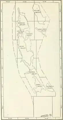
1914 sketch map of Ukiah area showing location of arable valleys
Geography
Several shipping points on the railroad in the Ukiah and Sanel Valleys serve surrounding towns and resorts in the Coast Range. Hopland, California grew when the railroad came along, the old business centre from the time of the old toll roads, before the railway, being Old Hopland.[2] Other stops include:[2]
- Echo
- Cummiskey
- Pieta (38°55′36″N 123°03′19″W[3]) is located near the mouth of Pieta Creek 5 miles (8 km) southeast of Hopland,[4] at an elevation of 476 feet (145 m).[3] A post office operated here from 1891 to 1897.[4] The name honors a local Native American chief.[4]
- Fountain
- Largo (39°01′18″N 123°07′48″W[5]) is located on the Northwestern Pacific Railroad 10 miles (16 km) south-southeast of Ukiah,[6] at an elevation of 522 feet (159 m).[5] A post office operated here from 1889 to 1905, having moved in 1897.[6] The name honors Lemuel F. Long, a settler of 1858; "Largo" is Spanish for "long".[6]
- Henry
- El Roble (39°05′23″N 123°10′51″W[7] is located on the Northwestern Pacific Railroad 4.5 miles (7.2 km) south-southeast of Ukiah,[8] at an elevation of 564 feet (172 m).[7] El Roble (formerly El Robles) is a Spanish name meaning "the oak(s)".[9]
- Redwood Valley
- Laughlin
References
- Watson & Pendleton 1919, p. 2629.
- Watson & Pendleton 1919, p. 2636.
- "Pieta". Geographic Names Information System. United States Geological Survey, United States Department of the Interior.
- Durham 1998, p. 122
- "Largo". Geographic Names Information System. United States Geological Survey, United States Department of the Interior.
- Durham 1998, p. 91
- "El Roble". Geographic Names Information System. United States Geological Survey, United States Department of the Interior.
- Durham 1998, p. 57
- Gannett 1905, p. 118.
Bibliography
- Watson, E.B.; Pendleton, R.L. (1919). "Soil Survey of the Ukiah Area, California". Field Operations of the Bureau of Soils. Vol. 16 (1914). United States Bureau of Soils. p. 2636. (Soil Survey of the Ukiah Area, California at the Internet Archive)
- Durham, David L. (1998). California's Geographic Names: A Gazetteer of Historic and Modern Names of the State. Clovis, Calif.: Word Dancer Press. ISBN 1-884995-14-4.
- Gannett, Henry (1905). The Origin of Certain Place Names in the United States. Govt. Print. Off.
This article is issued from Wikipedia. The text is licensed under Creative Commons - Attribution - Sharealike. Additional terms may apply for the media files.