Laugar
Laugar is a village in the Northeastern Region Iceland, on the Reykjadalsá river, a left tributary of the Laxá í Aðaldal river. Route 1 runs through the village between Akureyri and Reykjahlíð.[1] It is largest village in the municipality of Þingeyjarsveit. In 2018, it had a population of 109 people.[2]
Laugar | |
|---|---|
village | |
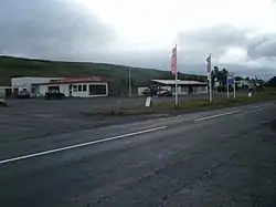
 View of Laugar | |
 Laugar | |
| Coordinates: 65°43′18″N 17°21′30″W | |
| Country | Iceland |
| Region | Northeastern Region |
| Constituency | Northeast Constituency |
| Municipality | Þingeyjarsveit |
| Population (2018) | |
| • Total | 109 |
| Postal code(s) | 650 |
| Municipal number | 6613 |
| Website | thingeyjarsveit |
Laugar developed around thermal springs,[3] hence its name, which in Icelandic means "hot springs". Laugar is located on the Diamond Circle tourist route. In its vicinity there are famous tourist attractions: Goðafoss waterfall (approx. 10 km (6.2 mi) to the west) and lake Mývatn (approx. 20 km (12 mi) to the southeast). However, 8 km (5.0 mi) to the north of the village, there is lake Vestmannsvatn.[1]
References
- "Map Viewer". National Land Survey of Iceland. Retrieved 2019-01-01.
- "Municipalities and urban nuclei". Hagstofa Íslands. Retrieved 2019-01-01.
- "Laugar". Visit North Iceland. Archived from the original on 2019-01-02. Retrieved 2019-01-01.
This article is issued from Wikipedia. The text is licensed under Creative Commons - Attribution - Sharealike. Additional terms may apply for the media files.