Lautertal, Bavaria
Lautertal is a municipality in the district of Coburg in Bavaria in Germany. Near Lautertal, there was between 1952 and 1992 a DECCA-transmitter.
Lautertal | |
|---|---|
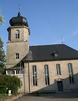 Protestant church | |
 Coat of arms | |
Location of Lautertal within Coburg district 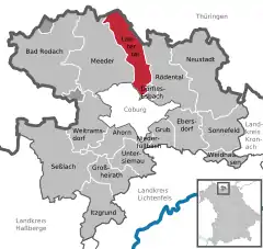 | |
 Lautertal  Lautertal | |
| Coordinates: 50°20′N 10°58′E | |
| Country | Germany |
| State | Bavaria |
| Admin. region | Oberfranken |
| District | Coburg |
| Government | |
| • Mayor (2019–25) | Karl Kolb[1] |
| Area | |
| • Total | 30.34 km2 (11.71 sq mi) |
| Highest elevation | 527 m (1,729 ft) |
| Lowest elevation | 300 m (1,000 ft) |
| Population (2022-12-31)[2] | |
| • Total | 4,520 |
| • Density | 150/km2 (390/sq mi) |
| Time zone | UTC+01:00 (CET) |
| • Summer (DST) | UTC+02:00 (CEST) |
| Postal codes | 96486 |
| Dialling codes | 09561, 09566 |
| Vehicle registration | CO, NEC |
| Website | www.gemeindelautertal.de |
Geography
Lautertal is in the north of the district of Coburg between the state of Thuringia and Coburg. The municipality consists of the six villages Unterlauter, Oberlauter, Tiefenlauter, Neukirchen, Tremersdorf and Rottenbach. The Buchberg (close to Rottenbach) is the highest elevation in the district.
Climate
| Climate data for Lautertal (1991–2020 normals) | |||||||||||||
|---|---|---|---|---|---|---|---|---|---|---|---|---|---|
| Month | Jan | Feb | Mar | Apr | May | Jun | Jul | Aug | Sep | Oct | Nov | Dec | Year |
| Average high °C (°F) | 2.6 (36.7) |
4.3 (39.7) |
9.0 (48.2) |
14.6 (58.3) |
18.8 (65.8) |
22.2 (72.0) |
24.4 (75.9) |
24.4 (75.9) |
19.1 (66.4) |
13.3 (55.9) |
6.8 (44.2) |
3.4 (38.1) |
13.6 (56.5) |
| Daily mean °C (°F) | 0.1 (32.2) |
0.8 (33.4) |
4.4 (39.9) |
9.1 (48.4) |
13.3 (55.9) |
16.5 (61.7) |
18.5 (65.3) |
18.1 (64.6) |
13.7 (56.7) |
9.0 (48.2) |
4.2 (39.6) |
1.0 (33.8) |
9.1 (48.4) |
| Average low °C (°F) | −2.5 (27.5) |
−2.4 (27.7) |
0.3 (32.5) |
3.5 (38.3) |
7.5 (45.5) |
10.6 (51.1) |
12.6 (54.7) |
12.4 (54.3) |
8.8 (47.8) |
5.3 (41.5) |
1.5 (34.7) |
−1.3 (29.7) |
4.7 (40.5) |
| Average precipitation mm (inches) | 57.0 (2.24) |
44.2 (1.74) |
45.4 (1.79) |
39.4 (1.55) |
65.2 (2.57) |
66.5 (2.62) |
84.9 (3.34) |
57.9 (2.28) |
57.2 (2.25) |
50.4 (1.98) |
55.7 (2.19) |
65.7 (2.59) |
681.0 (26.81) |
| Average precipitation days (≥ 1.0 mm) | 17.6 | 15.5 | 14.9 | 13.0 | 13.4 | 13.8 | 15.2 | 13.2 | 12.3 | 14.9 | 16.4 | 19.0 | 179.6 |
| Average relative humidity (%) | 85.1 | 81.4 | 75.6 | 68.7 | 69.5 | 70.4 | 70.7 | 69.7 | 77.1 | 83.1 | 87.0 | 87.2 | 77.1 |
| Mean monthly sunshine hours | 47.3 | 71.1 | 121.5 | 180.4 | 205.7 | 211.4 | 220.8 | 208.9 | 150.5 | 102.4 | 44.6 | 37.4 | 1,594.3 |
| Source: World Meteorological Organization[3] | |||||||||||||
Infrastructure
Car
Lautertal has two junctions to Bundesautobahn 73 motorway in the north and south. The former route of the Bundesstraße 4 is the longest main road of the village.
Rail Transport
The Eisenach-Lichtenfels railway line, also known as the Werra Valley Railway, ran through Lautertal until the 1970s. There was a train station in Tiefenlauter. Due to the fact that Thuringia belonged to the GDR, the train traffic was separated, later the route had to be abandoned. A reactivation is demanded by many, however the municipality is against it.
Public Transport
Oberlauter and Unterlauter are connected to Coburg by city bus line 2. The additional line 8318 connects all the other villages with Coburg.
References
- Liste der ersten Bürgermeister/Oberbürgermeister in kreisangehörigen Gemeinden, Bayerisches Landesamt für Statistik, accessed 19 July 2021.
- Genesis Online-Datenbank des Bayerischen Landesamtes für Statistik Tabelle 12411-003r Fortschreibung des Bevölkerungsstandes: Gemeinden, Stichtag (Einwohnerzahlen auf Grundlage des Zensus 2011)
- "World Meteorological Organization Climate Normals for 1991–2020". World Meteorological Organization Climatological Standard Normals (1991–2020). National Oceanic and Atmospheric Administration. Retrieved 12 October 2023.
Towns and municipalities in Coburg (district) | ||
|---|---|---|
Coat of Arms of Coburg district | ||