Le Verrier (lunar crater)
Le Verrier is a small lunar impact crater located in the northern part of the Mare Imbrium. It was named after French mathematician and astronomer Urbain Le Verrier.[1] To the west is the slightly larger crater Helicon, and farther to the west-northwest lies the mountain-ringed bay Sinus Iridum.
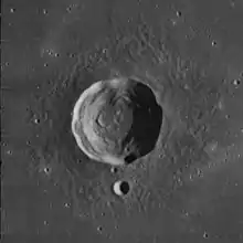
 Le Verrier seen by Lunar Orbiter 4 in 1967 | |
| Coordinates | 40.3°N 20.6°W |
|---|---|
| Diameter | 20 km |
| Depth | 2.1 km |
| Colongitude | 21° at sunrise |
| Eponym | Urbain Le Verrier |
View of Helicon (left) and Le Verrier (right). While Helicon's ejecta is buried by the mare lava, Le Verrier's is not. (The mountain on the horizon at left is Promontorium Laplace. Image taken by Apollo 15).
Le Verrier, sometimes written Leverrier, is a bowl-shaped feature with a nearly circular rim. The inner walls display the appearance of slumping along the upper edges. The inner wall and floor to the southeast appears more irregular than elsewhere.
Chang'e 3 landed north of Le Verrier in December 2013.
Satellite craters
By convention these features are identified on lunar maps by placing the letter on the side of the crater midpoint that is closest to Le Verrier.
| Le Verrier | Latitude | Longitude | Diameter |
|---|---|---|---|
| A | 38.1° N | 17.3° W | 4 km |
| B | 40.1° N | 12.9° W | 5 km |
| D | 39.7° N | 12.3° W | 9 km |
| E | 42.4° N | 16.9° W | 7 km |
| S | 38.9° N | 20.6° W | 3 km |
| T | 39.8° N | 20.7° W | 4 km |
| U | 37.2° N | 13.1° W | 4 km |
| V | 37.8° N | 14.2° W | 3 km |
| W | 39.4° N | 13.9° W | 3 km |
| X | 41.6° N | 12.1° W | 3 km |
References
- "Le Verrier (lunar crater)". Gazetteer of Planetary Nomenclature. USGS Astrogeology Research Program.
- Andersson, L. E.; Whitaker, E. A. (1982). NASA Catalogue of Lunar Nomenclature. NASA RP-1097.
- Bussey, B.; Spudis, P. (2004). The Clementine Atlas of the Moon. New York: Cambridge University Press. ISBN 978-0-521-81528-4.
- Cocks, Elijah E.; Cocks, Josiah C. (1995). Who's Who on the Moon: A Biographical Dictionary of Lunar Nomenclature. Tudor Publishers. ISBN 978-0-936389-27-1.
- McDowell, Jonathan (July 15, 2007). "Lunar Nomenclature". Jonathan's Space Report. Retrieved 2007-10-24.
- Menzel, D. H.; Minnaert, M.; Levin, B.; Dollfus, A.; Bell, B. (1971). "Report on Lunar Nomenclature by the Working Group of Commission 17 of the IAU". Space Science Reviews. 12 (2): 136–186. Bibcode:1971SSRv...12..136M. doi:10.1007/BF00171763. S2CID 122125855.
- Moore, Patrick (2001). On the Moon. Sterling Publishing Co. ISBN 978-0-304-35469-6.
- Price, Fred W. (1988). The Moon Observer's Handbook. Cambridge University Press. ISBN 978-0-521-33500-3.
- Rükl, Antonín (1990). Atlas of the Moon. Kalmbach Books. ISBN 978-0-913135-17-4.
- Webb, Rev. T. W. (1962). Celestial Objects for Common Telescopes (6th revised ed.). Dover. ISBN 978-0-486-20917-3.
- Whitaker, Ewen A. (1999). Mapping and Naming the Moon. Cambridge University Press. ISBN 978-0-521-62248-6.
- Wlasuk, Peter T. (2000). Observing the Moon. Springer. ISBN 978-1-85233-193-1.
External links
- Wood, Chuck (2006-08-20). "Out the Porthole". Lunar Photo of the Day. Retrieved 2016-09-18., excellent earth-based image of Sinus Iridum and vicinity, including Helicon and Le Verrier
Wikimedia Commons has media related to Le Verrier (crater).
This article is issued from Wikipedia. The text is licensed under Creative Commons - Attribution - Sharealike. Additional terms may apply for the media files.