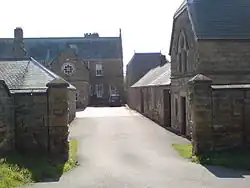
Upsall Castle
Upsall Castle is a fourteenth-century ruin, park and manor house in Upsall, in the Hambleton district of North Yorkshire, England.
| Upsall Castle | |
|---|---|
 "Upsall Castle" entrance, 2007 | |
| Type | Masonry Castle |
| Location | Upsall, North Yorkshire |
| Coordinates | 54.27536°N 1.30092°W |
| Area | 5,525 m2 |
| Built | 1327 |
| Owner | Gerald Turton |
History
Some records state that there was a building of some construction on the site of the castle in 1130 and used by Roger De Mowbray.[1] The earliest extant building on the site is the ruin of a quadrangular castle, probably begun in 1327 by Geoffrey Scrope, which was reputedly demolished in the Civil War. His son, Henry continued the building work. The last mention in records of the castle are in 1660.[2]
Surveys revealed that the part of the southeast tower (Kitchen Tower) remained, as did the foundations for the south and west walls. The north and eastern structures of the old castle now lie beneath ground level. Mason markings are still visible, including the faded arms of the Scrope family.[3] The castle,[4] the old Gatehouse located west of the present day Garden Cottage [5] and the remains of the old castle walls are all listed monuments.[6] This castle was replaced by a manor house, which was rebuilt in the 19th century[7] and then rebuilt again following destruction by fire in 1918.[8]
The castle was part of the manor of the Scrope family until 1520, when it passed to Elizabeth, the daughter of Thomas Scrope, wife of Sir Ralph Fitz Randolph. It then passed again via his daughter, Agnes, to her son Christopher Wyvill, son of Ripon MP, Sir Marmaduke Wyvill. After this it passed to the Crown in 1577, before coming into the hands of the Constable family. They held it until 1768 when it was purchased briefly by William Chapman who sold it the Turton family.[3]
Legends
John Constable, who resided at the castle in 1610,[9] was a supporter of the Royal cause during the Civil War. The 19th-century writers William Grainge and John Gilbert Baker noted that he reportedly left a curse on any owner of Upsall who should prove disloyal to his king and country.[10] The writers also recounted a folklore story of a man who dug under a bush at Upsall Castle, finding a pot of gold; later on, a stranger revealed to him that there was another pot of gold buried under the first, which he then dug up as well.[11][12]
References
- Grainge, William; Baker, John Gilbert (1859). The Vale of Mowbray: A Historical and Topographical Account of Thirsk and Its Neighbourhood. Simpkin, Marshall, and co. p. 264. Archived from the original on 26 October 2016. Retrieved 13 October 2016.
- Davis, Philip (20 January 2007). "Upsall Castle". Gatehouse: The comprehensive gazetteer of the medieval fortifications and castles of England and Wales. Archived from the original on 23 August 2022. Retrieved 2 February 2007.
- Page, William, ed. (1923). 'Parishes: South Kilvington', in A History of the County of York North Riding: Volume 2. London. pp. 40–43. Archived from the original on 15 August 2016. Retrieved 6 January 2017.
{{cite book}}: CS1 maint: location missing publisher (link) - Historic England. "Upsall Castle (Grade II*) (1008734)". National Heritage List for England. Retrieved 6 January 2017.
- Historic England. "Gatehouse to Upsall Castle (Grade II*) (1241656)". National Heritage List for England. Retrieved 6 January 2017.
- Historic England. "Remains of Upsall Castle Walls (Grade II*) (1241639)". National Heritage List for England. Retrieved 6 January 2017.
- "GENUKI: South Kilvington Parish information from Bulmers' 1890". www.genuki.org.uk. Archived from the original on 5 July 2008. Retrieved 4 August 2008.
- "Upsall, North Yorkshire". Archived from the original on 26 October 2016. Retrieved 2 February 2007.
- Collins, Francis, ed. (1888). 'Yorkshire Fines: 1579', in Feet of Fines of the Tudor Period [Yorks]: Part 2, 1571-83. Leeds. pp. 124–146. Archived from the original on 7 January 2017. Retrieved 6 January 2017.
{{cite book}}: CS1 maint: location missing publisher (link) - Grainge, William; Baker, John Gilbert (1859). The Vale of Mowbray: A Historical and Topographical Account of Thirsk and Its Neighbourhood. Simpkin, Marshall, and co. pp. 271–272. Archived from the original on 26 October 2016. Retrieved 13 October 2016.
- Grainge, William; Baker, John Gilbert (1859). The Vale of Mowbray: A Historical and Topographical Account of Thirsk and Its Neighbourhood. Simpkin, Marshall, and co. pp. 277–278. Archived from the original on 26 October 2016. Retrieved 13 October 2016.
- Gutch, Eliza (1901). County Folk-Lore, vol. 2: Examples of Printed Folk-Lore Concerning the North Riding of Yorkshire, York, and the Ainsty. Published for the Folk-Lore Society by David Nutt, London. pp. 408–409.