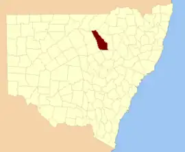
Leichhardt County

Leichhardt County is one of the 141 Cadastral divisions of New South Wales. It is located south of the Namoi River and includes land on both sides of the Castlereagh River, including Coonamble.

Leichhardt
New South Wales
Location in New South Wales
Lands administrative divisions around Leichhardt:
Narran Finch Baradine
Clyde Leichhardt Baradine
Gregory Ewenmar Gowen

Leichhardt County was named in honour of the Prussian naturalist and explorer Friedrich Wilhelm Ludwig Leichhardt (1813-1848).[1]

Parishes within the county

A full list of parishes found within this county; their current LGA and mapping coordinates to the approximate centre of each location is as follows:

ParishLGACoordinates
AberfoyleWalgett Shire30°05′54″S 147°50′04″E
AmosWalgett Shire30°13′54″S 147°54′04″E
BaronneCoonamble Shire31°11′54″S 148°40′04″E
BimbleCoonamble Shire30°51′54″S 148°24′04″E
BogewangWalgett Shire30°13′54″S 147°44′04″E
BorgaraWalgett Shire30°11′54″S 147°46′04″E
BrewanWalgett Shire30°07′54″S 147°36′04″E
BuchananCoonamble Shire31°05′54″S 148°48′04″E
BudgeonCoonamble Shire31°07′54″S 148°18′04″E
BulgahCoonamble Shire30°27′54″S 148°20′04″E
BulgogarCoonamble Shire30°41′54″S 148°29′04″E
BullaroraCoonamble Shire30°37′54″S 148°20′04″E
CalgaCoonamble Shire31°00′54″S 148°42′04″E
CambaraCoonamble Shire31°11′54″S 148°18′04″E
CampbellCoonamble Shire30°47′54″S 148°28′04″E
CarrabearCoonamble Shire30°57′54″S 148°02′04″E
CarwellCoonamble Shire31°12′54″S 148°45′04″E
CastlereaghWalgett Shire30°17′54″S 147°54′04″E
CollinouieCoonamble Shire30°27′54″S 148°24′04″E
ColmiaWalgett Shire30°15′54″S 148°04′04″E
ColomyWalgett Shire30°19′54″S 147°58′04″E
ConimbiaCoonamble Shire30°41′54″S 148°04′04″E
Cooeyah WarrahCoonamble Shire30°27′54″S 148°14′04″E
CoonambleCoonamble Shire30°57′54″S 148°20′04″E
CoonamoonaCoonamble Shire30°55′08″S 148°37′08″E
DahomeyWalgett Shire30°27′54″S 148°08′04″E
DevonWalgett Shire30°21′54″S 147°54′04″E
DinoaCoonamble Shire30°51′54″S 148°14′04″E
EdgeroiCoonamble Shire30°57′54″S 148°08′04″E
EllisCoonamble Shire31°07′54″S 148°30′04″E
ElongeryCoonamble Shire31°12′54″S 148°55′04″E
EulahCoonamble Shire31°03′54″S 148°14′04″E
EurokaWalgett Shire30°05′54″S 148°06′04″E
GeelnoyCoonamble Shire30°45′54″S 148°46′04″E
GelambulaCoonamble Shire30°51′54″S 148°28′04″E
GidgerygahWalgett Shire30°21′54″S 147°48′04″E
GidginbillaWalgett Shire30°23′54″S 148°14′04″E
GilgoomaCoonamble Shire30°46′39″S 148°32′16″E
GilguldryCoonamble Shire31°11′54″S 148°22′04″E
GilwarnyWalgett Shire30°25′54″S 147°50′04″E
GoorianawaCoonamble Shire31°06′55″S 148°52′40″E
Gungalman NorthCoonamble Shire30°25′54″S 147°58′04″E
GungalmanCoonamble Shire30°31′54″S 148°02′04″E
GunnaWalgett Shire30°11′54″S 148°10′04″E
KeadoolCoonamble Shire30°25′54″S 148°22′04″E
KidgarWalgett Shire30°15′54″S 147°50′04″E
MagometonCoonamble Shire31°03′54″S 148°35′04″E
MatoureeCoonamble Shire30°25′54″S 148°18′04″E
MogilCoonamble Shire30°51′54″S 148°04′04″E
MoolambongCoonamble Shire31°07′54″S 148°24′04″E
MooraWalgett Shire30°17′54″S 148°14′04″E
MoorambillaCoonamble Shire30°57′54″S 148°24′04″E
MourabieWalgett Shire30°07′54″S 147°44′04″E
MowlmaCoonamble Shire30°41′54″S 148°10′04″E
MundareCoonamble Shire30°57′54″S 148°30′04″E
MundareCoonamble Shire30°59′54″S 148°32′04″E
MungeryCoonamble Shire31°05′54″S 148°40′04″E
Munna MunnaCoonamble Shire30°31′54″S 147°56′04″E
MurraimanCoonamble Shire30°58′26″S 148°42′27″E
NarratigahCoonamble Shire31°00′54″S 148°48′04″E
NebeaCoonamble Shire30°51′22″S 148°33′54″E
NedgeraCoonamble Shire30°27′54″S 147°56′04″E
NeinbyCoonamble Shire31°03′54″S 148°06′04″E
NelgowrieCoonamble Shire30°53′54″S 148°10′04″E
NimbiaCoonamble Shire30°41′54″S 147°56′04″E
NingearCoonamble Shire30°47′54″S 148°08′04″E
NoonbarCoonamble Shire30°59′54″S 148°35′04″E
NugalWalgett Shire30°21′54″S 148°05′04″E
OuralCoonamble Shire30°35′54″S 148°08′04″E
ParmiduanCoonamble Shire31°08′54″S 148°51′04″E
Pier PierCoonamble Shire30°35′54″S 147°54′04″E
Quanda QuandaCoonamble Shire31°06′54″S 148°46′04″E
QuonmoonaCoonamble Shire31°01′54″S 148°18′04″E
SussexWalgett Shire30°09′54″S 147°58′04″E
TahroneCoonamble Shire30°43′54″S 148°22′04″E
TallegarCoonamble Shire31°05′54″S 148°14′04″E
TeremboneCoonamble Shire30°37′54″S 148°41′04″E
TeridgerieCoonamble Shire30°55′54″S 149°48′04″E
TharaCoonamble Shire30°37′54″S 148°26′04″E
TolooraWalgett Shire30°09′54″S 148°04′04″E
TooloonCoonamble Shire30°57′54″S 148°14′04″E
TooraCoonamble Shire30°33′54″S 148°02′04″E
TrielmonWalgett Shire30°15′54″S 147°58′04″E
UlarbieWalgett Shire30°03′54″S 148°00′04″E
UlundryCoonamble Shire31°12′54″S 148°30′04″E
UrawilkieCoonamble Shire30°50′28″S 148°42′42″E
WaddiwongWalgett Shire30°07′54″S 147°54′04″E
Walcha CouncilCoonamble Shire30°36′54″S 148°35′04″E
Walla WallaCoonamble Shire31°08′54″S 148°34′04″E
WambelongCoonamble Shire31°12′54″S 148°50′04″E
Warraba EastCoonamble Shire30°42′54″S 148°39′04″E
WarrabahCoonamble Shire30°55′54″S 148°02′04″E
WarraganWalgett Shire30°17′54″S 148°08′04″E
Warren DownsWalgett Shire30°17′54″S 147°44′04″E
WarrenaCoonamble Shire30°57′54″S 148°28′04″E
WeetalibaCoonamble Shire30°42′54″S 148°34′04″E
WillagaCoonamble Shire30°47′15″S 148°38′33″E
WingadeeCoonamble Shire30°09′54″S 148°12′04″E
WingadeeCoonamble Shire30°27′54″S 148°12′04″E
WinnabaCoonamble Shire30°29′54″S 148°34′04″E
WoolingarCoonamble Shire30°39′54″S 148°14′04″E
WorinjerongCoonamble Shire31°12′54″S 148°34′04″E
YarragooraCoonamble Shire30°45′54″S 148°14′04″E
YarrayinCoonamble Shire30°47′54″S 148°02′04″E
YoeeCoonamble Shire30°51′54″S 148°20′04″E
YouendahWalgett Shire30°03′54″S 147°56′04″E
YumaCoonamble Shire30°47′54″S 148°22′04″E

References

  1. "Leichhardt". Geographical Names Register (GNR) of NSW. Geographical Names Board of New South Wales. Retrieved 4 August 2013.
This article is issued from Wikipedia. The text is licensed under Creative Commons - Attribution - Sharealike. Additional terms may apply for the media files.