Lemon Dam
The earthen dam is a project of the United States Bureau of Reclamation and was completed in 1963, at 284 feet (87 m) high and 1,360 feet (410 m) long at its crest.[2] The dam impounds the Florida River for flood control and irrigation water storage, operated by the local Florida Water Conservancy District. 120 kW of hydroelectric power is generated here.
| Lemon Dam | |
|---|---|
 | |
| Country | United States |
| Location | La Plata County, Colorado |
| Purpose | Irrigation, flood control, hydroelectric generation |
| Status | Operational |
| Opening date | 1963 |
| Designed by | United States Bureau of Reclamation |
| Operator(s) | Florida Water Conservancy District |
| Dam and spillways | |
| Impounds | Florida River |
| Height | 284 ft (87 m) |
| Length | 1,360 ft (410 m) |
| Reservoir | |
| Normal elevation | 2,478 m (8,130 ft) [1] |
| Installed capacity | 120 kW |

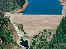
Aerial view of the Lemon Reservoir

Hills of the Weminuche Wilderness near Lemon Reservoir
Lemon Reservoir is about three miles (4.8 km) long, one-half mile (0.8 km) wide, has a total surface area of 622 acres (252 ha) and a total capacity of 40,145 acre-feet.[3]
Climate
Lemon Dam has a humid continental climate(Köppen Dfb).
| Climate data for Lemon Dam, Colorado, 1991–2020 normals: 8110ft (2472m) | |||||||||||||
|---|---|---|---|---|---|---|---|---|---|---|---|---|---|
| Month | Jan | Feb | Mar | Apr | May | Jun | Jul | Aug | Sep | Oct | Nov | Dec | Year |
| Average high °F (°C) | 37.0 (2.8) |
39.6 (4.2) |
47.1 (8.4) |
54.1 (12.3) |
63.1 (17.3) |
74.7 (23.7) |
79.0 (26.1) |
76.3 (24.6) |
69.9 (21.1) |
58.6 (14.8) |
46.3 (7.9) |
37.3 (2.9) |
56.9 (13.8) |
| Daily mean °F (°C) | 23.2 (−4.9) |
25.5 (−3.6) |
33.2 (0.7) |
40.2 (4.6) |
49.0 (9.4) |
58.6 (14.8) |
63.9 (17.7) |
61.9 (16.6) |
55.6 (13.1) |
45.1 (7.3) |
34.1 (1.2) |
25.2 (−3.8) |
43.0 (6.1) |
| Average low °F (°C) | 9.3 (−12.6) |
11.4 (−11.4) |
19.3 (−7.1) |
26.3 (−3.2) |
34.8 (1.6) |
42.5 (5.8) |
48.7 (9.3) |
47.5 (8.6) |
41.3 (5.2) |
31.6 (−0.2) |
21.8 (−5.7) |
13.1 (−10.5) |
29.0 (−1.7) |
| Average precipitation inches (mm) | 2.70 (69) |
2.48 (63) |
1.97 (50) |
1.63 (41) |
1.63 (41) |
0.95 (24) |
3.04 (77) |
3.48 (88) |
3.43 (87) |
2.50 (64) |
2.07 (53) |
2.41 (61) |
28.29 (718) |
| Average snowfall inches (cm) | 29.10 (73.9) |
28.50 (72.4) |
18.90 (48.0) |
9.80 (24.9) |
1.70 (4.3) |
0.00 (0.00) |
0.00 (0.00) |
0.00 (0.00) |
0.00 (0.00) |
3.00 (7.6) |
14.10 (35.8) |
25.90 (65.8) |
131 (332.7) |
| Source: NOAA[4] | |||||||||||||
References
- U.S. Geological Survey Geographic Names Information System: Lemon Dam
- "Dam details - Lemon Dam - Bureau of Reclamation". Archived from the original on 2012-09-25. Retrieved 2012-07-27.
- http://www.recreation.gov/recAreaDetails.do?contractCode=NRSO&recAreaId=55&agencyCode=131
- "Lemon Dam, Colorado 1991-2020 Monthly Normals". Retrieved October 10, 2023.
This article is issued from Wikipedia. The text is licensed under Creative Commons - Attribution - Sharealike. Additional terms may apply for the media files.