Leon, Kansas
Leon is a city in Butler County, Kansas, United States.[1] As of the 2020 census, the population of the city was 669.[3]
Leon, Kansas | |
|---|---|
 City Hall, Elks Rebekah Hall, Bank (2022) | |
 Location within Butler County and Kansas | |
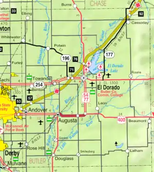 KDOT map of Butler County (legend) | |
| Coordinates: 37°41′23″N 96°47′02″W[1] | |
| Country | United States |
| State | Kansas |
| County | Butler |
| Township | Little Walnut |
| Founded | 1879 |
| Incorporated | 1882 |
| Named for | Leon, Iowa |
| Area | |
| • Total | 0.72 sq mi (1.87 km2) |
| • Land | 0.72 sq mi (1.87 km2) |
| • Water | 0.00 sq mi (0.00 km2) |
| Elevation | 1,348 ft (411 m) |
| Population | |
| • Total | 669 |
| • Density | 930/sq mi (360/km2) |
| Time zone | UTC-6 (CST) |
| • Summer (DST) | UTC-5 (CDT) |
| ZIP code | 67074 |
| Area code | 316 |
| FIPS code | 20-39450 |
| GNIS ID | 2395679[1] |
| Website | cityofleon.com |
History
Leon was founded in 1879.[4] It was named after Leon, Iowa.[5] The first building, built in 1879, was the blacksmith shop of H. Belton.[6] Leon was incorporated as a city in 1882.[7]
Geography
According to the United States Census Bureau, the city has a total area of 0.75 square miles (1.94 km2), all of it land.[8] Leon is located in Little Walnut Township, Butler County, Kansas, and it is its principal city.
Demographics
| Census | Pop. | Note | %± |
|---|---|---|---|
| 1880 | 113 | — | |
| 1890 | 456 | 303.5% | |
| 1900 | 527 | 15.6% | |
| 1910 | 494 | −6.3% | |
| 1920 | 427 | −13.6% | |
| 1930 | 587 | 37.5% | |
| 1940 | 573 | −2.4% | |
| 1950 | 518 | −9.6% | |
| 1960 | 541 | 4.4% | |
| 1970 | 510 | −5.7% | |
| 1980 | 667 | 30.8% | |
| 1990 | 707 | 6.0% | |
| 2000 | 645 | −8.8% | |
| 2010 | 704 | 9.1% | |
| 2020 | 669 | −5.0% | |
| U.S. Decennial Census | |||
2010 census
As of the census[9] of 2010, there were 704 people, 264 households, and 188 families residing in the city. The population density was 938.7 inhabitants per square mile (362.4/km2). There were 297 housing units at an average density of 396.0 per square mile (152.9/km2). The racial makeup of the city was 91.9% White, 0.6% African American, 2.0% Native American, 0.3% Asian, 1.6% from other races, and 3.7% from two or more races. Hispanic or Latino of any race were 3.0% of the population.
There were 264 households, of which 38.3% had children under the age of 18 living with them, 50.0% were married couples living together, 11.7% had a female householder with no husband present, 9.5% had a male householder with no wife present, and 28.8% were non-families. 25.8% of all households were made up of individuals, and 14% had someone living alone who was 65 years of age or older. The average household size was 2.67 and the average family size was 3.13.
The median age in the city was 34.6 years. 30.3% of residents were under the age of 18; 8.3% were between the ages of 18 and 24; 22.1% were from 25 to 44; 24.1% were from 45 to 64; and 15.2% were 65 years of age or older. The gender makeup of the city was 50.6% male and 49.4% female.
2000 census
As of the census[10] of 2000, there were 645 people, 245 households, and 175 families residing in the city. The population density was 1,090.8 inhabitants per square mile (421.2/km2). There were 269 housing units at an average density of 454.9 per square mile (175.6/km2). The racial makeup of the city was 93.64% White, 0.62% African American, 1.71% Native American, 1.55% from other races, and 2.48% from two or more races. Hispanic or Latino of any race were 4.96% of the population.
There were 245 households, out of which 38.4% had children under the age of 18 living with them, 57.6% were married couples living together, 10.6% had a female householder with no husband present, and 28.2% were non-families. 24.5% of all households were made up of individuals, and 11.8% had someone living alone who was 65 years of age or older. The average household size was 2.63 and the average family size was 3.18.
In the city, the population was spread out, with 31.6% under the age of 18, 7.4% from 18 to 24, 27.9% from 25 to 44, 19.2% from 45 to 64, and 13.8% who were 65 years of age or older. The median age was 33 years. For every 100 females, there were 89.1 males. For every 100 females age 18 and over, there were 95.1 males.
The median income for a household in the city was $40,089, and the median income for a family was $48,000. Males had a median income of $35,938 versus $25,859 for females. The per capita income for the city was $18,953. About 6.7% of families and 6.6% of the population were below the poverty line, including 6.6% of those under age 18 and 12.8% of those age 65 or over.
Education
The community is served by Bluestem USD 205 public school district. The Bluestem High School mascot is Lions.
Prior to school unification, the Leon High School mascot was also Lions.[11] The Leon Lions won the following Kansas State High School championships:
- 1948 Boys Track & Field - Class B [12]
- 1949 Boys Track & Field - Class B [12]
- 1965 Boys Cross Country - Class B [13]
2017 KSHSAA Class 2A-1A State Champions Baseball
References
- U.S. Geological Survey Geographic Names Information System: Leon, Kansas
- "2019 U.S. Gazetteer Files". United States Census Bureau. Retrieved July 24, 2020.
- "Profile of Leon, Kansas in 2020". United States Census Bureau. Archived from the original on November 13, 2021. Retrieved November 12, 2021.
- Kansas State Historical Society (1916). Biennial Report of the Board of Directors of the Kansas State Historical Society. Kansas State Printing Plant. pp. 152.
- "Profile for Leon, Kansas". ePodunk. Retrieved June 5, 2014.
- "William G. Cutler's History of the State of Kansas (1883)". Archived from the original on March 5, 2003.
- Blackmar, Frank Wilson (1912). Kansas: A Cyclopedia of State History, Volume 2. Standard Publishing Company. pp. 138.
- "US Gazetteer files 2010". United States Census Bureau. Archived from the original on July 2, 2012. Retrieved July 6, 2012.
- "U.S. Census website". United States Census Bureau. Retrieved July 6, 2012.
- "U.S. Census website". United States Census Bureau. Retrieved January 31, 2008.
- "Bluestem High School - Lions Tales Yearbook (Leon, KS)". E-YEARBOOK.COM. Retrieved January 10, 2017.
- "Track & Field". KSHSAA. Retrieved January 6, 2017.
- "Cross Country". KSHSAA. Retrieved January 8, 2017.
Further reading
External links
Municipalities and communities of Butler County, Kansas, United States | ||
|---|---|---|
| Cities | 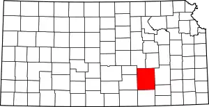 Map of Kansas highlighting Butler County | |
| Unincorporated communities | ||
| Ghost towns | ||
| Townships | ||
| Footnotes | †This community is designated a Census-Designated Place (CDP) by the United States Census Bureau. | |