Lewistown, Pennsylvania
Lewistown is a borough in and the county seat of Mifflin County, Pennsylvania, United States.[3] It is the principal city of the Lewistown, PA Micropolitan Statistical Area, which encompasses all of Mifflin County.[4] It lies along the Juniata River, 61 miles (98 km) northwest of Harrisburg. The number of people living in the borough in 1900 was 4,451; in 1910, 8,166; in 1940, 13,017; and in 2000, 8,998. The population was 8,561 at the 2020 census.[5] Of the four communities in the United States named "Lewistown", this borough is the largest.
Lewistown, Pennsylvania | |
|---|---|
 The post office in Lewistown | |
 Seal | |
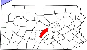
 Location of Lewistown in Mifflin County, Pennsylvania. | |
 Lewistown  Lewistown | |
| Coordinates: 40°35′51″N 77°34′24″W | |
| Country | United States |
| State | Pennsylvania |
| County | Mifflin |
| Settled | 1790 |
| Incorporated | 1795 |
| Government | |
| • Type | Borough Council |
| • Mayor | Deborah Bargo |
| • Council President | Larry Searer |
| • Council Vice President | Jim Steele |
| Area | |
| • Total | 2.05 sq mi (5.31 km2) |
| • Land | 2.03 sq mi (5.26 km2) |
| • Water | 0.02 sq mi (0.05 km2) |
| Elevation | 520 ft (160 m) |
| Population | |
| • Total | 8,579 |
| • Density | 4,226.11/sq mi (1,631.44/km2) |
| Time zone | UTC-5 (Eastern (EST)) |
| • Summer (DST) | UTC-4 (EDT) |
| ZIP code | 17044 |
| Area code(s) | 717 and 223 |
| FIPS code | 42-43000 |
| School district | Mifflin County School District |
| Website | lewistownborough |
History
.jpg.webp)

Early history
The borough was incorporated in 1795 and was named for William "Bill" Lewis, a Quaker and a member of the legislature, who was responsible for the designation of the borough, which was then known as the Village of Ohesson, as the county seat of Mifflin County.[6]
During the late 19th century Mifflin County became the crossroads of the Commonwealth. Located near the geographic center of the state, the area became a hub for traffic moving in every direction.
Early roads crisscrossed the region, but it was the eventual construction of the Pennsylvania Canal and the railroads that followed that truly positioned Mifflin County as an economic force in the state.
Lewistown, as the major city in Mifflin County, saw its economy expand dramatically as entrepreneurs launched companies to construct canal boats or build inns offering lodging for travelers and workers.
At its zenith, Mifflin County was one of the busiest centers for cargo and passenger traffic in the United States. But with the demise of the canal system, Mifflin County eventually lost its place as a major transportation hub.
American Civil War
On April 16, 1861, Lewistown sent its Logan Guards, a militia group originally formed in 1858, to Washington, D.C. for its defense. They were one of only five companies, all recruited in Pennsylvania, to share the honor of being the first U.S. troops sent to the capital. Monument Square, situated at the intersection of Main and Market Streets in Lewistown, serves as a memorial to these men.
Tropical Storm Agnes
Lewistown lost its role as a major transportation hub, but still boasted a strong industrial economy until the early 1970s when the county's industries began a slow decline. Hurricane Agnes June 1972 crippled the local economy.
On June 19, Hurricane Agnes made initial landfall along the Florida Panhandle as a weak Category 1 Hurricane. Agnes then proceeded through Georgia, South Carolina and North Carolina before she moved back over the Atlantic off the North Carolina coast on June 21.
After regaining strength over the Atlantic, she made landfall again over southeastern New York on June 22 and moved westward in an arc over southern New York into north-central Pennsylvania. She became nearly stationary over Pennsylvania by morning of June 23, but was soon absorbed by a low-pressure system that slowly drifted northeastward from Pennsylvania into New York.
Rainfall from storm over the Mid-Atlantic region ranged from 2 to 3 inches (51 to 76 mm) in the extreme upper basins of the Potomac and North Branch Susquehanna Rivers to 18 inches (460 mm) near Shamokin, Pennsylvania, in the Main Stem Susquehanna River basin. An average of 6 to 10 inches (150 to 250 mm) of rain fell over the Mid-Atlantic region. The soil, already well watered by spring rains, could not absorb so much water so quickly.
While flooding from the Juniata River was somewhat controlled due to a dam at Raystown Lake, 44 miles (71 km) west of Lewistown, the county experienced extensive flooding from the river and major streams which resulted in the permanent closure of many businesses along the river. Most notably, the flood submerged much of the American Viscose Corporation plant, then a division of FMC Corporation. The facility, located on the banks of the Juniata River across from Lewistown proper, manufactured rayon fiber (primarily for rayon-belted automobile tires), polyester and Avistrap.
FMC was one of two major employers in the area at the time, the other being the Standard Steel Works. The "Viscose" plant was only marginally profitable before the storm and the cost to reopen was prohibitive. (Ironically, the demand for rayon fabric for trendy clothing shot upward only a few years later.) Rayon production, and with it, thousands of good-paying jobs, moved to another FMC plant in Front Royal, Virginia. The Lewistown polyester plant reopened, but it rehired only a fraction of the previous workforce. The site eventually became the Mifflin County Industrial Plaza and a variety of businesses have come and gone since then.
Economic downturn
In the wake of the failure of Lewistown's industry, a long period of decline began. The 1990s saw the loss of several plants, including Masland and Lear, as well as Standard Steel filing for reorganization bankruptcy. The early 2000s saw the loss of Scotty's Fashions, Mann Edge Tool, Overhead Door shuttering its sectional division, and Ford New Holland shuttering its Belleville plant which also led to the closing of the Belleville Foundry.
Present day
In 2011, Standard Steel merged with Japanese company Sumitomo Industries and is now known as Nippon Steel; this merger effectively saved the jobs of 500 union laborers as well as many others in the area. First Quality, an adult incontinence products manufacturer, opened a facility in Lewistown that employs approximately 400 people. Geisinger purchased Lewistown Hospital in 2013 and expanded services including a helicopter pad, the Geisinger LIFE program and a new clinic in nearby Reedsville.
Today, Lewistown is seeing a boom in new small businesses by young entrepreneurs including restaurants and retail. The construction of an enhanced highway system between Lewistown and State College was completed in 2020 and better connects the two communities.
Geography
According to the United States Census Bureau, the borough has a total area of 2.0 square miles (5.2 km2), all land. The town's borders lie along the Juniata River.
Climate
| Climate data for Lewistown, Pennsylvania (1991–2020 normals, extremes 1938–present) | |||||||||||||
|---|---|---|---|---|---|---|---|---|---|---|---|---|---|
| Month | Jan | Feb | Mar | Apr | May | Jun | Jul | Aug | Sep | Oct | Nov | Dec | Year |
| Record high °F (°C) | 72 (22) |
78 (26) |
87 (31) |
94 (34) |
97 (36) |
102 (39) |
106 (41) |
103 (39) |
103 (39) |
95 (35) |
85 (29) |
75 (24) |
106 (41) |
| Mean maximum °F (°C) | 58.4 (14.7) |
61.2 (16.2) |
72.4 (22.4) |
84.1 (28.9) |
89.2 (31.8) |
92.0 (33.3) |
94.5 (34.7) |
92.7 (33.7) |
89.7 (32.1) |
81.8 (27.7) |
72.1 (22.3) |
60.3 (15.7) |
96.0 (35.6) |
| Average high °F (°C) | 37.0 (2.8) |
40.4 (4.7) |
49.4 (9.7) |
62.6 (17.0) |
72.8 (22.7) |
80.7 (27.1) |
85.3 (29.6) |
83.6 (28.7) |
76.8 (24.9) |
65.0 (18.3) |
52.6 (11.4) |
41.4 (5.2) |
62.3 (16.8) |
| Daily mean °F (°C) | 29.0 (−1.7) |
31.4 (−0.3) |
39.3 (4.1) |
50.8 (10.4) |
60.9 (16.1) |
69.5 (20.8) |
74.0 (23.3) |
72.4 (22.4) |
65.3 (18.5) |
53.7 (12.1) |
42.8 (6.0) |
33.9 (1.1) |
51.9 (11.1) |
| Average low °F (°C) | 21.0 (−6.1) |
22.3 (−5.4) |
29.2 (−1.6) |
39.0 (3.9) |
49.1 (9.5) |
58.3 (14.6) |
62.6 (17.0) |
61.1 (16.2) |
53.8 (12.1) |
42.5 (5.8) |
33.0 (0.6) |
26.3 (−3.2) |
41.5 (5.3) |
| Mean minimum °F (°C) | 5.5 (−14.7) |
8.4 (−13.1) |
14.5 (−9.7) |
26.7 (−2.9) |
36.0 (2.2) |
46.2 (7.9) |
52.9 (11.6) |
51.0 (10.6) |
40.7 (4.8) |
30.3 (−0.9) |
21.3 (−5.9) |
13.4 (−10.3) |
3.3 (−15.9) |
| Record low °F (°C) | −17 (−27) |
−14 (−26) |
3 (−16) |
15 (−9) |
26 (−3) |
32 (0) |
41 (5) |
38 (3) |
28 (−2) |
21 (−6) |
6 (−14) |
−16 (−27) |
−17 (−27) |
| Average precipitation inches (mm) | 2.89 (73) |
2.31 (59) |
3.57 (91) |
3.53 (90) |
4.16 (106) |
3.95 (100) |
3.64 (92) |
3.61 (92) |
4.40 (112) |
3.75 (95) |
3.06 (78) |
3.27 (83) |
42.14 (1,070) |
| Average snowfall inches (cm) | 9.1 (23) |
6.9 (18) |
4.3 (11) |
0.2 (0.51) |
0.0 (0.0) |
0.0 (0.0) |
0.0 (0.0) |
0.0 (0.0) |
0.0 (0.0) |
0.1 (0.25) |
0.9 (2.3) |
4.7 (12) |
26.2 (67) |
| Average precipitation days (≥ 0.01 in) | 11.2 | 9.6 | 11.3 | 13.2 | 14.2 | 12.1 | 10.8 | 10.7 | 10.2 | 10.7 | 9.9 | 11.2 | 135.1 |
| Average snowy days (≥ 0.1 in) | 3.8 | 3.5 | 1.9 | 0.1 | 0.0 | 0.0 | 0.0 | 0.0 | 0.0 | 0.0 | 0.4 | 2.2 | 11.9 |
| Source: NOAA[7][8] | |||||||||||||
Water source
The source of the borough's city water comes from the Laurel Creek Reservoir, which is located in Seven Mountains going towards State College.
Demographics
| Census | Pop. | Note | %± |
|---|---|---|---|
| 1800 | 523 | — | |
| 1810 | 474 | −9.4% | |
| 1820 | 773 | 63.1% | |
| 1830 | 1,479 | 91.3% | |
| 1840 | 2,058 | 39.1% | |
| 1850 | 2,733 | 32.8% | |
| 1860 | 2,638 | −3.5% | |
| 1870 | 2,737 | 3.8% | |
| 1880 | 3,222 | 17.7% | |
| 1890 | 3,273 | 1.6% | |
| 1900 | 4,451 | 36.0% | |
| 1910 | 8,166 | 83.5% | |
| 1920 | 9,849 | 20.6% | |
| 1930 | 13,357 | 35.6% | |
| 1940 | 13,017 | −2.5% | |
| 1950 | 13,894 | 6.7% | |
| 1960 | 12,640 | −9.0% | |
| 1970 | 11,098 | −12.2% | |
| 1980 | 9,830 | −11.4% | |
| 1990 | 9,341 | −5.0% | |
| 2000 | 8,998 | −3.7% | |
| 2010 | 8,338 | −7.3% | |
| 2020 | 8,561 | 2.7% | |
| 2021 (est.) | 8,518 | [5] | −0.5% |
| Sources:[9][10][11][12][2] | |||
As of the census[11] of 2010, there were 8,338 people, 3,742 households, and 2,030 families residing in the borough. The population density was 4,138.7 inhabitants per square mile (1,598.0/km2). There were 4,345 housing units at an average density of 2,156.7 per square mile (832.7/km2). The racial makeup of the borough was 95.2% White, 1.5% Black or African American, 0.3% Native American, 0.3% Asian, 0.9% from other races, and 1.8% from two or more races. Hispanic or Latino of any race were 3.1% of the population.
There were 3,742 households, out of which 27.7% had children under the age of 18 living with them, 34.8% were married couples living together, 4.8% had a male householder with no wife present, 14.6% had a female householder with no husband present, and 45.8% were non-families. 39.3% of all households were made up of individuals, and 17.3% had someone living alone who was 65 years of age or older. The average household size was 2.21, and the average family size was 2.93.
In the borough, the population was spread out, with 23.3% under the age of 18, 8.6% from 18 to 24, 25.3% from 25 to 44, 26.6% from 45 to 64, and 16.2% who were 65 years of age or older. The median age was 40 years. For every 100 females, there were 89.5 males. For every 100 females age 18 and over, there were 85.3 males.
The median income for a household in the borough was $26,584, and the median income for a family was $38,356. The per capita income for the borough was $16,447. About 22.8% of families and 27.4% of the population were below the poverty line, including 47.0% of those under age 18 and 13.6% of those age 65 or over.
Notable people
- Jean Acker, actress
- Viola Alberti, actress
- Ralph Baker, professional American football player
- Carl Barger, attorney and baseball executive
- Frances McEwen Belford, "Mother of the Lincoln Highway"
- John Brown, member of the U.S. House of Representatives from Pennsylvania
- Joseph Campanella, actor
- Bob Cupp, golf course designer
- Kelly Harper, recording artist and singer-songwriter
- Joseph Henderson, member of the U.S. House of Representatives from Pennsylvania
- Laura Johns, suffragist, journalist
- Julia Kasdorf, poet
- John Lilley, U.S. Medal of Honor winner for gallantry during the American Civil War
- El McMeen, attorney and acoustic steel-string fingerstyle guitarist
- Carolyn Meyer, author of novels for children and young adults
- LeRoy Millette, senior justice of the Supreme Court of Virginia
- Jack Womer, decorated World War II veteran
Historical buildings in the Lewistown Borough
The Embassy Theatre, McCoy House, Mifflin County Courthouse, Montgomery Ward Building, and Wollner Building are listed on the National Register of Historic Places.[13]
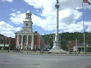 Mifflin County Courthouse and Monument Square
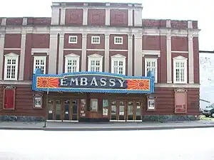 The Historic Embassy Theatre
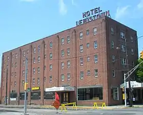 Hotel Lewistown (now Ansel Apartments)
Transportation
- Lewistown (Amtrak station)
- Greyhound
- Fullington Trailways
Media
Newspapers
Television stations
- WHTM 27 Harrisburg (27.1 ABC, 27.2 ION, 27.3 GetTV, 27.4 Laff)
- WPMT 43 York (43.1 FOX, 43.2 AntennaTV)
- WHP 21 Harrisburg (21.1 CBS, 21.2 MyNetworkTV, 21.3 CW)
- WGAL 8 Lancaster (8.1 NBC, 8.2 MeTV)
- WJAC 6 Johnstown (6.1 NBC, 6.2 Charge!, 6.3 Comet, 6.4 CW)
- WTAJ 10 Altoona (10.1 CBS, 10.2 Escape, 10.3 Laff, 10.4 Grit)
- WHVL 29 State College (29.1 MyNetworkTV, 29.2 Buzzr)
Radio stations
| FM stations | ||||
|---|---|---|---|---|
| Call letters | Frequency | Format | Location | Owner |
| WRYV | 88.7 | Christian Contemporary | Milroy | Invisible Allies |
| WTLR | 89.9 | Religious | State College | Central Pennsylvania Christian Institute |
| WJRC | 90.9 | Christian Contemporary | Lewistown | Salt and Light Media Ministries, Inc. |
| WIBF | 92.5 | Country | Mexico | Seven Mountains Media (Kristin Cantrell) |
| WBUS | 93.7 | Classic Rock | Boalsburg | Forever Broadcasting |
| WQKX | 94.1 | CHR | Sunbury | Sunbury Broadcasting Corporation |
| WMRF | 95.7 | Hot AC | Lewistown | Seven Mountains Media (Kristin Cantrell) |
| WVNW | 96.7 | Country | Burnham | WVNW, Inc. |
| WFGY | 98.1 | Country | Altoona | Forever Broadcasting |
| WMAJ | 99.5 | Hot AC | Centre Hall | Seven Mountains Media (Kristin Cantrell) |
| W262DO | 100.3 | Light AC | Lewistown | WVNW, Inc. |
| WFGE | 101.1 | Country | Tyrone | Forever Broadcasting |
| WCHX | 105.5 | Mainstream Rock | Burnham | Mifflin County Communications, Inc. |
| WDBF | 106.3 | Country | Mount Union | Seven Mountains Media (Kristin Cantrell) |
| WQJU | 107.1 | Religious | Mifflintown | Central Pennsylvania Christian Institute |
| AM stations | ||||
|---|---|---|---|---|
| Call letters | Frequency | Format | Location | Owner |
| WLUI | 670 | News/Talk | Lewistown | Seven Mountains Media (Kristin Cantrell) |
| WKVA | 920 | Light AC | Burnham | WVNW, Inc. |
| WHUN | 1150 | News/Talk | Huntingdon | Seven Mountains Media (Kristin Cantrell) |
| WJUN | 1220 | Sports | Mexico | Seven Mountains Media (Kristin Cantrell) |
Cable television
Lewistown was one of the first three communities that formed the cable company later known as Cox Communications.
Education
The Borough of Lewistown is served by the Mifflin County School District. It is also home to the only local Catholic Elementary school, Sacred Heart of Jesus , which educates children of any religion in grades K–5.
Lewistown is home to the Pennsylvania State Fire Academy, which is the only such facility in the state. Firefighting in Lewistown is very important, as volunteer firefighters have strong allegiance to the multiple independent fire companies in the borough to which they devote their time.
References
- "ArcGIS REST Services Directory". United States Census Bureau. Retrieved October 12, 2022.
- "Census Population API". United States Census Bureau. Retrieved Oct 12, 2022.
- "Find a County". National Association of Counties. Archived from the original on May 31, 2011. Retrieved 2011-06-07.
- 1
- Bureau, US Census. "City and Town Population Totals: 2020—2021". Census.gov. US Census Bureau. Retrieved July 26, 2022.
- "Lewistown Gazette (Lewistown, Pa.) 1843-1944". Library of Congress. Retrieved 2023-08-18.
- "NowData – NOAA Online Weather Data". National Oceanic and Atmospheric Administration. Retrieved August 7, 2021.
- "Station: Lewistown, PA". U.S. Climate Normals 2020: U.S. Monthly Climate Normals (1991–2020). National Oceanic and Atmospheric Administration. Retrieved August 7, 2021.
- "Number of Inhabitants: Pennsylvania" (PDF). 18th Census of the United States. U.S. Census Bureau. Retrieved 22 November 2013.
- "Pennsylvania: Population and Housing Unit Counts" (PDF). U.S. Census Bureau. Retrieved 22 November 2013.
- "U.S. Census website". United States Census Bureau. Retrieved 2008-01-31.
- "Incorporated Places and Minor Civil Divisions Datasets: Subcounty Population Estimates: April 1, 2010 to July 1, 2012". U.S. Census Bureau. Archived from the original on 11 June 2013. Retrieved 25 November 2013.
- "National Register Information System". National Register of Historic Places. National Park Service. July 9, 2010.
External links
- Borough of Lewistown official website
- PA Department of Environmental Protection Hurricane Agnes site
- . New International Encyclopedia. 1905.
Places adjacent to Lewistown, Pennsylvania | |
|---|---|
Articles Relating to Lewistown, Pennsylvania | |||||||||||||||||||
|---|---|---|---|---|---|---|---|---|---|---|---|---|---|---|---|---|---|---|---|
| |||||||||||||||||||