Qionglai City
Qionglai (simplified Chinese: 邛崃; traditional Chinese: 邛崍; pinyin: Qiónglái) is a county-level city of Sichuan Province, Southwest China, it is under the administration of the prefecture-level city of Chengdu. It is located around 60 kilometres (37 mi) from downtown Chengdu. The city is located on the western edge of the Sichuan Basin and in the foothills of the Qionglai Mountains that bound the basin from the west, and is bordered by the prefecture-level city of Ya'an to the west.
Qionglai
邛崃市 | |||||||||||||||||||||||||||||||||||||||||||||||||||||||||||||||
|---|---|---|---|---|---|---|---|---|---|---|---|---|---|---|---|---|---|---|---|---|---|---|---|---|---|---|---|---|---|---|---|---|---|---|---|---|---|---|---|---|---|---|---|---|---|---|---|---|---|---|---|---|---|---|---|---|---|---|---|---|---|---|---|
.jpg.webp) | |||||||||||||||||||||||||||||||||||||||||||||||||||||||||||||||
.png.webp) Location of Qionglai in Sichuan | |||||||||||||||||||||||||||||||||||||||||||||||||||||||||||||||
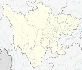 Qionglai Location in Sichuan | |||||||||||||||||||||||||||||||||||||||||||||||||||||||||||||||
| Coordinates: 30°24′22″N 103°27′32″E[1] | |||||||||||||||||||||||||||||||||||||||||||||||||||||||||||||||
| Country | People's Republic of China | ||||||||||||||||||||||||||||||||||||||||||||||||||||||||||||||
| Province | Sichuan | ||||||||||||||||||||||||||||||||||||||||||||||||||||||||||||||
| Sub-provincial city | Chengdu | ||||||||||||||||||||||||||||||||||||||||||||||||||||||||||||||
| Area | |||||||||||||||||||||||||||||||||||||||||||||||||||||||||||||||
| • Total | 1,377 km2 (532 sq mi) | ||||||||||||||||||||||||||||||||||||||||||||||||||||||||||||||
| Population (2010)[2] | |||||||||||||||||||||||||||||||||||||||||||||||||||||||||||||||
| • Total | 612,753 | ||||||||||||||||||||||||||||||||||||||||||||||||||||||||||||||
| Time zone | UTC+8 (China Standard) | ||||||||||||||||||||||||||||||||||||||||||||||||||||||||||||||
| Postal code | 6115XX | ||||||||||||||||||||||||||||||||||||||||||||||||||||||||||||||
| Chengdu district map |
| ||||||||||||||||||||||||||||||||||||||||||||||||||||||||||||||
Transport
- China National Highway 318
- Rivers and Water
There are many rivers around in Qionglai City, so it has abundant water power. South River, Zhuojiang River, Xiejiang River and Pujiang River flow through this city, and they are 217.15 kilometers long in total. The quantity of runoff of surface water may reach 991 million cubic meters, including 532.8 million cubic meters which can be made use of by humans. Underground water can reach 106 million cubic meters. Surface and underground water create many opportunities to support agriculture and manufacture.
Administrative divisions
Qionglai City has 6 streets and 8 towns. Qionglai City People's Government is located in Linqiong Street Wenjun Street No. 108
Streets
- Wenjun street(文君街道)
- Linqiong street(临邛街道)
- Guyi street(固驿街道)
- Yang'an street(羊安街道)
- Gaogeng street(高梗街道)
- Kongming street(孔明街道)
Towns
- Sangyuan town(桑园镇)
- Pingle town(平乐镇)
- Jiaguan town(夹关镇)
- Huojing town(火井镇)
- Linji town(临济镇)
- Tiantaishan town(天台山镇)
- Nanbaoshan town(南宝山镇)
- Datong town(大同镇)
Geographical Situation
Location Information
- Located in the southwest of Chengdu, it is located between latitude 30°12′~30°33′ north and longitude 103°04′~103°45′ east, with a length of 68.5 km from east to west and a width of 38.5 km from north to south. The city covers an area of 1,377 square kilometers.[3]
- It is adjacent to Dayi in the north, Xinjin District and Pengshan District in the east, Yucheng District and Lushan County in Ya'an City in the west, and Pujiang County and Meishan District in Ya'an in the south. The city government is located at No. 108 Wenjun Street, Wenjun Street, 65 kilometers from the main city of Chengdu.[3]
Hydrological Information
- Qionglai City has a wide range of rivers and abundant water resources. The South River, the Dwarf (Yin) River, the Xiejiang River, the Pujiang River and the Yuxi River flow through the territory, with a total length of 217.15 kilometers.
Climate
| Climate data for Qionglai (1991–2020 normals, extremes 1981–2010) | |||||||||||||
|---|---|---|---|---|---|---|---|---|---|---|---|---|---|
| Month | Jan | Feb | Mar | Apr | May | Jun | Jul | Aug | Sep | Oct | Nov | Dec | Year |
| Record high °C (°F) | 19.1 (66.4) |
22.8 (73.0) |
31.6 (88.9) |
32.7 (90.9) |
35.0 (95.0) |
36.8 (98.2) |
36.0 (96.8) |
37.7 (99.9) |
36.1 (97.0) |
29.5 (85.1) |
26.2 (79.2) |
19.0 (66.2) |
37.7 (99.9) |
| Average high °C (°F) | 9.6 (49.3) |
12.6 (54.7) |
17.4 (63.3) |
23.1 (73.6) |
26.9 (80.4) |
28.8 (83.8) |
30.6 (87.1) |
30.4 (86.7) |
26.1 (79.0) |
21.1 (70.0) |
16.5 (61.7) |
11.0 (51.8) |
21.2 (70.1) |
| Daily mean °C (°F) | 6.1 (43.0) |
8.6 (47.5) |
12.6 (54.7) |
17.6 (63.7) |
21.5 (70.7) |
24.1 (75.4) |
25.8 (78.4) |
25.5 (77.9) |
22.0 (71.6) |
17.5 (63.5) |
12.9 (55.2) |
7.6 (45.7) |
16.8 (62.3) |
| Average low °C (°F) | 3.5 (38.3) |
5.7 (42.3) |
9.1 (48.4) |
13.6 (56.5) |
17.5 (63.5) |
20.5 (68.9) |
22.4 (72.3) |
22.1 (71.8) |
19.4 (66.9) |
15.2 (59.4) |
10.4 (50.7) |
5.1 (41.2) |
13.7 (56.7) |
| Record low °C (°F) | −4.0 (24.8) |
−2.9 (26.8) |
−0.9 (30.4) |
5.0 (41.0) |
7.0 (44.6) |
13.8 (56.8) |
16.4 (61.5) |
17.0 (62.6) |
12.3 (54.1) |
4.2 (39.6) |
0.2 (32.4) |
−4.5 (23.9) |
−4.5 (23.9) |
| Average precipitation mm (inches) | 11.7 (0.46) |
17.0 (0.67) |
31.4 (1.24) |
64.1 (2.52) |
87.3 (3.44) |
116.9 (4.60) |
218.0 (8.58) |
270.8 (10.66) |
135.1 (5.32) |
55.0 (2.17) |
23.0 (0.91) |
11.0 (0.43) |
1,041.3 (41) |
| Average precipitation days (≥ 0.1 mm) | 10.2 | 10.1 | 13.1 | 14.6 | 15.2 | 16.7 | 16.8 | 16.3 | 17.6 | 17.1 | 10.3 | 8.3 | 166.3 |
| Average snowy days | 0.9 | 0.3 | 0 | 0 | 0 | 0 | 0 | 0 | 0 | 0 | 0 | 0.3 | 1.5 |
| Average relative humidity (%) | 83 | 80 | 78 | 77 | 75 | 79 | 83 | 83 | 85 | 86 | 85 | 85 | 82 |
| Mean monthly sunshine hours | 42.8 | 51.7 | 75.4 | 98.7 | 102.2 | 93.7 | 111.8 | 117.6 | 58.6 | 45.7 | 50.5 | 46.2 | 894.9 |
| Percent possible sunshine | 13 | 16 | 20 | 25 | 24 | 22 | 26 | 29 | 16 | 13 | 16 | 15 | 20 |
| Source: China Meteorological Administration[4][5] | |||||||||||||
See also
References
- Google (2014-07-02). "Qionglai" (Map). Google Maps. Google. Retrieved 2014-07-02.
- 我市2010年第六次全国人口普查数据公报 (in Simplified Chinese). Government of Chengdu. 2011-05-13. Archived from the original on September 30, 2011. Retrieved 2011-08-04.
- "市情介绍" [City Information]. 邛崃市人民政府 (in Chinese). 2023-04-06.
- 中国气象数据网 – WeatherBk Data (in Simplified Chinese). China Meteorological Administration. Retrieved 14 April 2023.
- 中国气象数据网 (in Simplified Chinese). China Meteorological Administration. Retrieved 14 April 2023.