List of municipalities in Delaware
Delaware is a state located in the Mid-Atlantic. According to the 2016 United States Census estimate, Delaware is the 6th least populous state with 989,948 inhabitants but the 2nd smallest by land area spanning 1,948.54 square miles (5,046.7 km2) of land.[1] Delaware is divided into three counties and contains 57 incorporated places consisting of cities, towns, and villages.[2][3]
.svg.png.webp)
Map of the United States with Delaware highlighted
As of 2020, the largest municipality by population in Delaware is Wilmington with 70,898 residents, while the largest by area is Dover which spans 23.668 sq mi (61.30 km2). The smallest municipality by both measurements is Hartly with 73 residents in an area of 0.057 sq mi (0.15 km2).
List of municipalities
- Largest incorporated places in Delaware by population
 Skyline of Wilmington, the largest city in Delaware

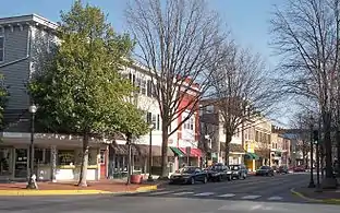
 Downtown Middletown, fourth largest municipality in Delaware

.jpg.webp)
| † | County seat |
|---|---|
|
‡ |
State capital and county seat |
| Name | Type | County(ies)[2] | Population
(2020)[4] |
Population
(2010) |
Change | Land area
(2020)[5] |
Population density | Incorporated[6] | |
|---|---|---|---|---|---|---|---|---|---|
| sq mi | km2 | ||||||||
| Arden | Village | New Castle | 430 | 439 | −2.1% | 0.249 | 0.64 | 1,726.9/sq mi (666.8/km2) | December 22, 1965 |
| Ardencroft | Village | New Castle | 226 | 231 | −2.2% | 0.089 | 0.23 | 2,539.3/sq mi (980.4/km2) | July 7, 1976 |
| Ardentown | Village | New Castle | 255 | 264 | −3.4% | 0.234 | 0.61 | 1,089.7/sq mi (420.8/km2) | June 30, 1975 |
| Bellefonte | Town | New Castle | 1,225 | 1,193 | +2.7% | 0.177 | 0.46 | 6,920.9/sq mi (2,672.2/km2) | March 9, 1915 |
| Bethany Beach | Town | Sussex | 954 | 1,060 | −10.0% | 1.148 | 2.97 | 831.0/sq mi (320.9/km2) | March 29, 1909 |
| Bethel | Town | Sussex | 239 | 171 | +39.8% | 0.440 | 1.14 | 543.2/sq mi (209.7/km2) | April 4, 1907 |
| Blades | Town | Sussex | 1,179 | 1,241 | −5.0% | 0.556 | 1.44 | 2,120.5/sq mi (818.7/km2) | March 10, 1915 |
| Bowers | Town | Kent | 278 | 335 | −17.0% | 0.311 | 0.81 | 893.9/sq mi (345.1/km2) | March 9, 1907 |
| Bridgeville | Town | Sussex | 2,568 | 2,048 | +25.4% | 4.821 | 12.49 | 532.7/sq mi (205.7/km2) | March 29, 1871 |
| Camden | Town | Kent | 3,715 | 3,464 | +7.2% | 3.746 | 9.70 | 991.7/sq mi (382.9/km2) | 1852 |
| Cheswold | Town | Kent | 1,923 | 1,380 | +39.3% | 1.838 | 4.76 | 1,046.2/sq mi (404.0/km2) | 1856 |
| Clayton | Town | Kent New Castle |
3,961 | 2,918 | +35.7% | 1.948 | 5.05 | 2,033.4/sq mi (785.1/km2) | 1887 |
| Dagsboro | Town | Sussex | 870 | 805 | +8.1% | 1.438 | 3.72 | 605.0/sq mi (233.6/km2) | February 9, 1899 |
| Delaware City | City | New Castle | 1,885 | 1,695 | +11.2% | 1.861 | 4.82 | 1,012.9/sq mi (391.1/km2) | 1851 |
| Delmar | Town | Sussex | 2,027 | 1,597 | +26.9% | 1.901 | 4.92 | 1,066.3/sq mi (411.7/km2) | March 9, 1899 |
| Dewey Beach | Town | Sussex | 353 | 341 | +3.5% | 0.331 | 0.86 | 1,066.5/sq mi (411.8/km2) | June 29, 1981 |
| Dover‡ | City | Kent | 39,403 | 36,047 | +9.3% | 23.668 | 61.30 | 1,664.8/sq mi (642.8/km2) | 1829 |
| Ellendale | Town | Sussex | 487 | 381 | +27.8% | 0.425 | 1.10 | 1,145.9/sq mi (442.4/km2) | March 30, 1905 |
| Elsmere | Town | New Castle | 6,229 | 6,131 | +1.6% | 0.987 | 2.56 | 6,311.0/sq mi (2,436.7/km2) | March 9, 1909 |
| Farmington | Town | Kent | 92 | 110 | −16.4% | 0.073 | 0.19 | 1,260.3/sq mi (486.6/km2) | March 15, 1909 |
| Felton | Town | Kent | 1,316 | 1,298 | +1.4% | 0.782 | 2.03 | 1,682.9/sq mi (649.8/km2) | February 21, 1861 |
| Fenwick Island | Town | Sussex | 343 | 379 | −9.5% | 0.331 | 0.86 | 1,036.3/sq mi (400.1/km2) | July 8, 1953 |
| Frankford | Town | Sussex | 790 | 847 | −6.7% | 0.729 | 1.89 | 1,083.7/sq mi (418.4/km2) | 1883 |
| Frederica | Town | Kent | 1,073 | 774 | +38.6% | 1.741 | 4.51 | 616.3/sq mi (238.0/km2) | 1826 |
| Georgetown† | Town | Sussex | 7,134 | 6,422 | +11.1% | 5.022 | 13.01 | 1,420.5/sq mi (548.5/km2) | March 2, 1869 |
| Greenwood | Town | Sussex | 990 | 973 | +1.7% | 0.794 | 2.06 | 1,246.9/sq mi (481.4/km2) | March 9, 1901 |
| Harrington | City | Kent | 3,774 | 3,562 | +6.0% | 2.724 | 7.06 | 1,385.5/sq mi (534.9/km2) | March 23, 1869 |
| Hartly | Town | Kent | 73 | 74 | −1.4% | 0.057 | 0.15 | 1,280.7/sq mi (494.5/km2) | March 23, 1869 |
| Henlopen Acres | Town | Sussex | 139 | 122 | +13.9% | 0.255 | 0.66 | 545.1/sq mi (210.5/km2) | June 4, 1970 |
| Houston | Town | Kent | 381 | 374 | +1.9% | 0.383 | 0.99 | 994.8/sq mi (384.1/km2) | March 26, 1913 |
| Kenton | Town | Kent | 215 | 261 | −17.6% | 0.176 | 0.46 | 1,221.6/sq mi (471.7/km2) | 1887 |
| Laurel | Town | Sussex | 3,865 | 3,708 | +4.2% | 2.766 | 7.16 | 1,397.3/sq mi (539.5/km2) | April 13, 1883 |
| Leipsic | Town | Kent | 178 | 183 | −2.7% | 0.297 | 0.77 | 599.3/sq mi (231.4/km2) | February 26, 1852 |
| Lewes | City | Sussex | 3,303 | 2,747 | +20.2% | 4.192 | 10.86 | 787.9/sq mi (304.2/km2) | February 2, 1818 |
| Little Creek | Town | Kent | 195 | 224 | −12.9% | 0.099 | 0.26 | 1,969.7/sq mi (760.5/km2) | 1899 |
| Magnolia | Town | Kent | 277 | 225 | +23.1% | 0.196 | 0.51 | 1,413.3/sq mi (545.7/km2) | April 3, 1885 |
| Middletown | Town | New Castle | 23,192 | 18,871 | +22.9% | 12.496 | 32.36 | 1,856.0/sq mi (716.6/km2) | February 12, 1861 |
| Milford | City | Sussex Kent |
11,190 | 9,559 | +17.1% | 9.853 | 25.52 | 1,135.7/sq mi (438.5/km2) | February 5, 1807 |
| Millsboro | Town | Sussex | 6,863 | 3,877 | +77.0% | 5.110 | 13.23 | 1,343.1/sq mi (518.6/km2) | March 9, 1893 |
| Millville | Town | Sussex | 1,825 | 544 | +235.5% | 2.552 | 6.61 | 715.1/sq mi (276.1/km2) | April 11, 1907 |
| Milton | Town | Sussex | 3,291 | 2,576 | +27.8% | 1.786 | 4.63 | 1,842.7/sq mi (711.5/km2) | March 17, 1865 |
| New Castle | City | New Castle | 5,551 | 5,285 | +5.0% | 3.478 | 9.01 | 1,596.0/sq mi (616.2/km2) | February 25, 1875 |
| Newark | City | New Castle | 30,601 | 31,454 | −2.7% | 9.427 | 24.42 | 3,246.1/sq mi (1,253.3/km2) | 1758 |
| Newport | Town | New Castle | 910 | 1,055 | −13.7% | 0.466 | 1.21 | 1,952.8/sq mi (754.0/km2) | April 17, 1873 |
| Ocean View | Town | Sussex | 2,636 | 1,882 | +40.1% | 2.773 | 7.18 | 950.6/sq mi (367.0/km2) | April 13, 1889 |
| Odessa | Town | New Castle | 366 | 364 | +0.5% | 0.507 | 1.31 | 721.9/sq mi (278.7/km2) | April 4, 1873 |
| Rehoboth Beach | City | Sussex | 1,108 | 1,327 | −16.5% | 1.175 | 3.04 | 943.0/sq mi (364.1/km2) | March 19, 1891 |
| Seaford | City | Sussex | 7,957 | 6,928 | +14.9% | 5.092 | 13.19 | 1,562.6/sq mi (603.3/km2) | April 6, 1865 |
| Selbyville | Town | Sussex | 2,878 | 2,167 | +32.8% | 3.582 | 9.28 | 803.5/sq mi (310.2/km2) | March 16, 1901 |
| Slaughter Beach | Town | Sussex | 218 | 207 | +5.3% | 1.419 | 3.68 | 153.6/sq mi (59.3/km2) | 1931 |
| Smyrna | Town | Kent New Castle |
12,883 | 10,023 | +28.5% | 6.237 | 16.15 | 2,065.6/sq mi (797.5/km2) | 1859 |
| South Bethany | Town | Sussex | 451 | 449 | +0.4% | 0.503 | 1.30 | 896.6/sq mi (346.2/km2) | June 18, 1969 |
| Townsend | Town | New Castle | 2,717 | 2,049 | +32.6% | 1.036 | 2.68 | 2,622.6/sq mi (1,012.6/km2) | April 3, 1885 |
| Viola | Town | Kent | 140 | 157 | −10.8% | 0.177 | 0.46 | 791.0/sq mi (305.4/km2) | 1913 |
| Wilmington† | City | New Castle | 70,898 | 70,851 | +0.1% | 10.895 | 28.22 | 6,507.4/sq mi (2,512.5/km2) | 1739 |
| Woodside | Town | Kent | 190 | 181 | +5.0% | 0.168 | 0.44 | 1,131.0/sq mi (436.7/km2) | April 4, 1911 |
| Wyoming | Town | Kent | 1,680 | 1,313 | +28.0% | 1.047 | 2.71 | 1,604.6/sq mi (619.5/km2) | March 20, 1869 |
| Total municipalities | — | — | 279,890 | 255,143 | +9.7% | '146.564 | 379.60 | 1,909.7/sq mi (737.3/km2) | — |
| Delaware | — | — | 989,948 | 897,934 | +10.2% | 1,948.0 | 5,045 | 508.2/sq mi (196.2/km2) | — |
References
- "Explore Census Data". data.census.gov. Retrieved July 24, 2022.
- "Domestic Names | U.S. Geological Survey". www.usgs.gov. Retrieved July 20, 2022.
- "Incorporated Municipalities". Guides to Services - State of Delaware. Retrieved July 24, 2022.
- "Explore Census Data". data.census.gov. Retrieved July 20, 2022.
- Bureau, US Census. "Gazetteer Files". Census.gov. Retrieved July 20, 2022.
- "Town and City Histories". Delaware Public Archives - State of Delaware. Retrieved July 20, 2022.
This article is issued from Wikipedia. The text is licensed under Creative Commons - Attribution - Sharealike. Additional terms may apply for the media files.