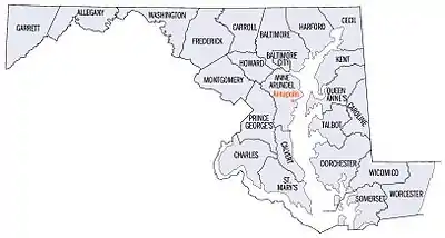
List of counties in Maryland
There are 23 counties and one independent city in the U.S. state of Maryland. Though an independent city rather than a county, the City of Baltimore is considered the equal of a county for most purposes and is a county-equivalent. Many of the counties in Maryland were named for relatives of the Barons Baltimore, who were the proprietors of the Maryland colony from its founding in 1634 through 1771. The Barons Baltimore were Catholic, and George Calvert, 1st Baron Baltimore, originally intended that the colony be a haven for English Catholics, though for most of its history Maryland has had a majority of Protestants.[1]
| Independent city and counties of Maryland | |
|---|---|
 | |
| Location | State of Maryland |
| Number | 23 counties and 1 Independent city |
| Populations | (Counties only): 19,320 (Kent) – 1,052,521 (Montgomery) |
| Areas | (Counties only): 254 square miles (660 km2) (Howard) – 695 square miles (1,800 km2) (Worcester) |
| Government | |
| Subdivisions |
|
History
The last new county formation in Maryland occurred when Garrett County was formed in 1872 from portions of Allegany County.[2] However, there have been numerous changes to county borders since that time, most recently when portions of the city of Takoma Park that had previously been part of Prince George's County were absorbed into Montgomery County in 1997.[3]
Outside Baltimore (which is an independent city) the county is the default unit of local government. Under Maryland law, counties exercise powers reserved in most other states at the municipal or state levels, so there is little incentive for a community to incorporate. Many of the state's most populous and economically important communities, such as Bethesda, Silver Spring, Columbia, and Towson are unincorporated and receive their municipal services from the county. In fact, there are no incorporated municipalities at all in Baltimore County or Howard County. The county-equivalent is also the provider of public schools—school districts as a separate level of government do not exist in Maryland.
The City of Baltimore generally possesses the same powers and responsibilities as the counties within the state. It is an entity nearly surrounded by but separate from the County of Baltimore, which has its county seat in Towson.
The Federal Information Processing Standard (FIPS) code, which is used by the United States government to uniquely identify states and counties, is provided with each entry.[4] Maryland's code is 24, which when combined with any county code would be written as 24XXX. The FIPS code for each county links to census data for that county.
List of counties
| County |
FIPS code[5] | County seat[2][6] | Est.[2][6] | Origin[2] | Etymology[2] | Flag | Seal |
Population[7] | Area[6][8] | Map |
|---|---|---|---|---|---|---|---|---|---|---|
| Allegany County | 001 | Cumberland | 1789 | Formed from part of Washington County | From Lenape oolikhanna, which means "beautiful stream" |  |  |
67,267 | 430 sq mi (1,114 km2) | 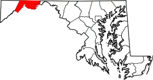 |
| Anne Arundel County | 003 | Annapolis | 1650 | Formed from part of St. Mary's County | Anne Arundell was the maiden name of the wife of Cecil Calvert, 2nd Baron Baltimore. Between 1654 and 1658 it was known as Providence County by Puritan settlers |  |  |
593,286 | 588 sq mi (1,523 km2) | 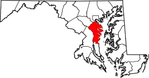 |
| Baltimore County | 005 | Towson | 1659 | Formed from unorganized territory | Cecil Calvert, 2nd Baron Baltimore, first proprietor of the Maryland colony |  |  |
846,161 | 682 sq mi (1,766 km2) |  |
| Baltimore City | 510 | Baltimore City | 1851 | Founded in 1729. Detached in 1851 from Baltimore County | Cecil Calvert, 2nd Baron Baltimore, first proprietor of the Maryland colony |  |  |
569,931 | 92 sq mi (238 km2) | 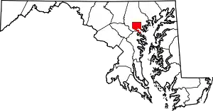 |
| Calvert County | 009 | Prince Frederick | 1654 | Formed as Patuxent County from unorganized territory. Renamed Calvert County in 1658 | The Calvert family; prior to 1658 it was called Patuxent County, after the Patuxent Indians, a branch of the Algonquians |  |  |
94,573 | 345 sq mi (894 km2) | 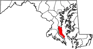 |
| Caroline County | 011 | Denton | 1773 | From parts of Dorchester County and Queen Anne's County | Lady Caroline Eden, daughter of Charles Calvert, 5th Baron Baltimore |  |  |
33,433 | 326 sq mi (844 km2) |  |
| Carroll County | 013 | Westminster | 1837 | From parts of Baltimore County and Frederick County | Charles Carroll of Carrollton, a representative to the Continental Congress and signatory of the Declaration of Independence |  |  |
175,305 | 452 sq mi (1,171 km2) | 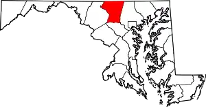 |
| Cecil County | 015 | Elkton | 1674 | From parts of Baltimore County and Kent County | Cecil is an Anglicized form of the first name of Cecil Calvert, 2nd Baron Baltimore |  | 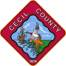 |
104,942 | 418 sq mi (1,083 km2) |  |
| Charles County | 017 | La Plata | 1658 | From unorganized territory | Charles Calvert, 3rd Baron Baltimore, second proprietor of the Maryland colony |  |  |
170,102 | 643 sq mi (1,665 km2) |  |
| Dorchester County | 019 | Cambridge | 1668 | From unorganized territory | Dorchester in Dorset, England; the Earl of Dorset was a friend of the Calvert family |  |  |
32,726 | 540 sq mi (1,399 km2) |  |
| Frederick County | 021 | Frederick | 1748 | From part of Prince George's County | Frederick Calvert, 6th Baron Baltimore, final proprietor of the Maryland colony |  |  |
287,079 | 667 sq mi (1,728 km2) |  |
| Garrett County | 023 | Oakland | 1872 | From part of Allegany County | John Work Garrett, president of the Baltimore and Ohio Railroad |  |  |
28,579 | 656 sq mi (1,699 km2) |  |
| Harford County | 025 | Bel Air | 1773 | From part of Baltimore County | Henry Harford, illegitimate son of Frederick Calvert, 6th Baron Baltimore |  |  |
263,867 | 527 sq mi (1,365 km2) |  |
| Howard County | 027 | Ellicott City | 1851 | From parts of Anne Arundel County and Baltimore County | John Eager Howard, an American Revolutionary War officer and governor of Maryland |  |  |
335,411 | 254 sq mi (658 km2) |  |
| Kent County | 029 | Chestertown | 1642 | From unorganized territory | The English county of Kent |  |  |
19,320 | 414 sq mi (1,072 km2) | 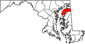 |
| Montgomery County | 031 | Rockville | 1776 | From part of Frederick County | Richard Montgomery, an American Revolutionary War general |  |  |
1,052,521 | 507 sq mi (1,313 km2) |  |
| Prince George's County | 033 | Upper Marlboro | 1696 | From parts of Calvert County and Charles County | Prince George of Denmark, the husband of Queen Anne of Great Britain |  |  |
946,971 | 498 sq mi (1,290 km2) |  |
| Queen Anne's County | 035 | Centreville | 1706 | From parts of Talbot County | Anne, Queen of Great Britain |  |  |
51,711 | 510 sq mi (1,321 km2) |  |
| Somerset County | 039 | Princess Anne | 1666 | From unorganized territory. | Mary, Lady Somerset, sister-in-law of Cecil Calvert, 2nd Baron Baltimore |  | 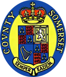 |
24,546 | 611 sq mi (1,582 km2) | 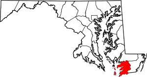 |
| St. Mary's County | 037 | Leonardtown | 1637 | From unorganized territory. Was named Potomac County between 1654 and 1658. | The Virgin Mary, first county named in a colony intended to be a haven for Catholics |  |  |
114,877 | 611 sq mi (1,582 km2) |  |
| Talbot County | 041 | Easton | 1662 | From part of Kent County | Grace, Lady Talbot, sister of Cecil Calvert, 2nd Baron Baltimore |  |  |
37,932 | 477 sq mi (1,235 km2) |  |
| Washington County | 043 | Hagerstown | 1776 | From part of Frederick County | George Washington, first President of the United States |  | .png.webp) |
155,590 | 468 sq mi (1,212 km2) | 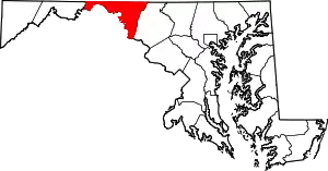 |
| Wicomico County | 045 | Salisbury | 1867 | From parts of Somerset County and Worcester County | The Wicomico River; in Lenape, wicko mekee indicated "a place where houses are built", possibly in reference to a settlement |  |  |
104,664 | 400 sq mi (1,036 km2) | 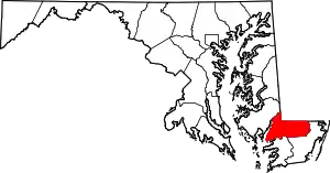 |
| Worcester County | 047 | Snow Hill | 1742 | From part of Somerset County | Mary Arundell, the wife of Sir John Somerset, son of Henry Somerset, 1st Marquess of Worcester, and sister of Anne Arundell, the wife of Cecil Calvert, 2nd Baron Baltimore |  |  |
53,866 | 695 sq mi (1,800 km2) |  |
Defunct counties
| County | Years of existence | Etymology |
|---|---|---|
| Old Charles County | 1650–1654 | King Charles I of England |
| Durham County | 1669–1672 | The English County Durham |
| Old Worcester County | 1672–1685 | Mary Arundell, the wife of Sir John Somerset, son of the 1st Marquess of Worcester, and sister of Anne Arundell, wife of Cecil Calvert, 2nd Baron Baltimore |
References
- Brugger, Robert J. (1988). Maryland: A Middle Temperament, 1634–1980. Baltimore: Johns Hopkins Press. ISBN 0-8018-3399-X.
- "Counties". Maryland Manual Online. Retrieved June 24, 2007.
- Brown, Deneen (June 28, 1997). "As Unification Nears, Takoma Park Residents Still a Divided People". The Washington Post. pp. A1. Retrieved June 24, 2007.
- "FIPS Publish 6-4". National Institute of Standards and Technology. Archived from the original on September 29, 2013. Retrieved April 11, 2007.
- "EPA County FIPS Code Listing". EPA.gov. Archived from the original on September 28, 2004. Retrieved February 23, 2008.
- National Association of Counties. "NACo – Find a county". Archived from the original on October 25, 2007. Retrieved April 30, 2008.
- "U.S. Census website". United States Census Bureau. Retrieved August 12, 2021.
- "Maryland QuickFacts". U.S. Census Bureau. Retrieved June 22, 2007.