List of Metrorrey stations

The following is the list of the 40 stations of the Monterrey Metro system (also referred to as Metrorrey) of Monterrey, Nuevo León, Mexico, organized by line.[1]

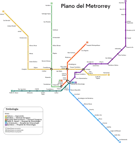
Map of the Monterrey Metro network.

Line 1 (yellow) Talleres – Exposición

Logo Station Station type Coordinates Comments
  Talleres Ground Level 25°45′14″N 100°21′55″W Terminal
San Bernabé Elevated 25°44′54″N 100°21′42″W Former terminal
Unidad Modelo Elevated 25°44′31″N 100°21′18″W
Aztlán Elevated 25°43′56″N 100°20′51″W
Penitenciaría Elevated 25°43′24″N 100°20′33″W
Alfonso Reyes Elevated 25°42′58″N 100°20′33″W
Mitras Elevated 25°42′20″N 100°20′33″W
Simón Bolívar Elevated 25°42′20″N 100°20′33″W
Hospital Elevated 25°41′31″N 100°20′39″W Near the UANL Medical Campus and the University Hospital (Hospital Civil).
Edison Elevated 25°41′13″N 100°20′01″W In the intersection of Edison street and Colon Avenue
Central Elevated 25°41′13″N 100°19′28″W One block from the main bus station.
Cuauhtémoc Elevated 25°41′10″N 100°19′01″W Transfer station; connects with line 2
Del Golfo Elevated 25°41′06″N 100°18′24″W
Felix U. Gómez Elevated 25°41′02″N 100°17′48″W Transfer station; connects with line 3
Parque Fundidora Elevated 25°41′01″N 100°17′17″W 2 blocks from Fundidora Park
Y Griega Elevated 25°40′59.96″N 100°16′45.60″W Near Fundidora Park
Eloy Cavazos Elevated 25°40′48″N 100°15′51″W
Lerdo de Tejada Elevated 25°40′47″N 100°15′10″W
Exposición Elevated 25°40′46″N 100°14′44″W Terminal

Line 2 (green) Sendero – General I. Zaragoza

Logo Station Station type Coordinates Comments
  Sendero Elevated 25°46′07″N 100°17′34″W Terminal
Tapia Elevated 25°45′33.34″N 100°17′44.44″W
San Nicolás Elevated 25°45′09.42″N 100°17′52.98″W Next to Clinica 6 of IMSS
Anáhuac Elevated 25°44′25″N 100°18′09″W Near the Anáhuac neighborhood
Universidad Elevated 25°43′28″N 100°18′30″W Former Terminal Station, Next to UANL
Niños Héroes Elevated 25°43′02″N 100°18′40″W Near Parque Niños Héroes and Estadio de Béisbol Monterrey
Regina Underground 25°42′28″N 100°18′51″W 3 blocks away from the Monumental Monterrey bullfight ring
General Anaya Underground 25°41′49″N 100°19′00″W Former terminal
Cuauhtémoc Underground 25°41′10″N 100°19′01″W Transfer station; connects with line 1
Alameda Underground 25°40′37″N 100°19′06″W
Fundadores Underground 25°40′22″N 100°19′11″W
Padre Mier Underground 25°40′08″N 100°18′56″W
General I. Zaragoza Underground 25°40′04″N 100°18′37″W Terminal and transfer station; connects with line 3. Located on the Macroplaza. Near MARCO Museum

Line 3 (orange) Hospital Metropolitano – General I. Zaragoza

Logo Station Station type Coordinates Comments
  Hospital Metropolitano Elevated Terminal
Los Ángeles Elevated
Ruiz Cortines Elevated
Colonia Moderna Elevated
Metalúrgicos Elevated
Félix U. Gómez Elevated Transfer station; connects with line 1
Colonia Obrera Elevated
Santa Lucía Elevated
General I. Zaragoza Underground Terminal and transfer station; connects with line 2

References

  1. "Red Metro" [Metro Network (map)] (in Spanish). Sistema de Transporte Colectivo Metrorrey. Archived from the original (jpg) on 2013-07-03. Retrieved 2014-06-28.
This article is issued from Wikipedia. The text is licensed under Creative Commons - Attribution - Sharealike. Additional terms may apply for the media files.