List of bays of the Firth of Clyde
This List of bays of the Firth of Clyde summarises the bays that are located in the islands of the Firth of Clyde in Scotland
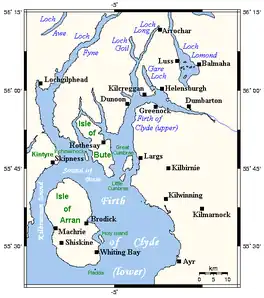
Map of Firth of Clyde
Arran
| Name | County | Nearest Town | Coordinates | Notes |
|---|---|---|---|---|
| Brodick Bay | North Ayrshire | Brodick | 55°34′16″N 5°06′23″W | [1] |
| Catacol Bay | North Ayrshire | Lochranza | 55°41′23″N 5°19′57″W | [2] |
| Drumadoon Bay | North Ayrshire | Blackwaterfoot | 55°29′48″N 5°20′29″W | [3] |
| Kerr's Port | North Ayrshire | Lamlash | 55°32′53″N 5°05′27″W | |
| Lamlash Bay | North Ayrshire | Lamlash | 55°31′51″N 5°06′13″W | |
| Machrie Bay | North Ayrshire | Machrie | 55°33′18″N 5°21′11″W | [3] |
| Port a' Ghille Ghlais | North Ayrshire | Whiting Bay | 55°26′21″N 5°09′13″W | |
| Port Dearg | North Ayrshire | Whiting Bay | 55°26′22″N 5°06′55″W | |
| Port na Feannaiche | North Ayrshire | Lagg | 55°27′23″N 5°17′32″W | |
| Port Mòr | North Ayrshire | Blackwaterfoot | 55°26′45″N 5°15′50″W | |
| Port Mòr | North Ayrshire | Whiting Bay | 55°28′54″N 5°05′23″W | |
| Porta Buidhe | North Ayrshire | Lagg, Arran | 55°26′27″N 5°07′26″W | |
| Porta Leacach | North Ayrshire | Kildonan | 55°26′57″N 5°05′34″W | |
| Sannox Bay | North Ayrshire | Sannox | 55°39′38″N 5°08′56″W | |
| Whiting Bay | North Ayrshire | Whiting Bay | 55°29′03″N 5°04′52″W | [4] |
Bute
Davaar
The small island of Davaar has no bays.
Great Cumbrae
| Name | County | Nearest Town | Coordinates | Notes |
|---|---|---|---|---|
| Ballochmartin Bay | North Ayrshire | Millport | 55°46′22″N 4°53′54″W | [9] |
| Bell Bay | North Ayrshire | Millport | 55°46′39″N 4°55′57″W | [10] |
| Deadman's Bay | North Ayrshire | Millport | 55°45′47″N 4°56′41″W | |
| Fintray Bay | North Ayrshire | Millport | 55°46′08″N 4°56′18″W | [11] |
| Holm Bay | North Ayrshire | Millport | 55°47′22″N 4°53′52″W | |
| Kames Bay | North Ayrshire | Millport | 55°45′08″N 4°55′02″W | [12] |
| Lady's Bay | North Ayrshire | Millport | 55°47′25″N 4°53′52″W | |
| Knox's Port | North Ayrshire | Millport | 55°45′00″N 4°55′57″W | |
| Millport Bay | North Ayrshire | Millport | 55°44′54″N 4°55′34″W | [13] |
| Newtown Bay | North Ayrshire | Millport | 55°45′06″N 4°55′40″W | |
| Skate Bay | North Ayrshire | Millport | 55°47′07″N 4°55′42″W | [14] |
| Stinking Bay | North Ayrshire | Millport | 55°47′29″N 4°55′05″W | [15] |
| White Bay | North Ayrshire | Millport | 55°47′31″N 4°54′32″W | [16] |
| Wine Bay | North Ayrshire | Millport | 55°47′28″N 4°55′03″W | [17] |
Holy Island
The small island of Holy Island has no bays.
Inchmarnock
The small island of Inchmarnock has no bays.
Little Cumbrae
| Name | County | Nearest Town | Coordinates | Notes |
|---|---|---|---|---|
| Long Bay | North Ayrshire | West Kilbride | 55°43′52″N 4°57′02″W | |
| Steadholm Bay | North Ayrshire | West Kilbride | 55°42′59″N 4°57′54″W | |
| Waterloo Bay | North Ayrshire | West Kilbride | 55°42′45″N 4°57′34″W |
Sanda
The small island of Sanda has no bays.
See also
References
- Adam and Charles Black (Firm) (1881). Black's Tourist's Guide to Scotland. p. 111. Retrieved 7 May 2021.
- United States. Hydrographic Office (1925). British Islands Pilot. U.S. Government Printing Office. p. 99.
- United States. Hydrographic Office (1925). British Islands Pilot. U.S. Government Printing Office. p. 98.
- "Whiting Bay". Visiting Scotland. Visit Scotland. Retrieved 30 May 2021.
- Groome, Francis Hindes (1882). Ordnance Gazetteer of Scotland: A Survey of Scottish Topography, Staistical, Biographical and Historical. Edinburgh: T. C. Jack. p. 79.
- "Balnakailly Bay". Gazetteer for Scotland. School of GeoSciences, University of Edinburgh and The Royal Scottish Geographical Society. Retrieved 25 April 2023.
- "Ettrick Bay". Gazetteer for Scotland. School of GeoSciences, University of Edinburgh and The Royal Scottish Geographical Society. Retrieved 20 April 2017.
- Murphy, Alan (10 April 2014). Scotland Highlands & Islands Footprint Handbook. Footprint Travel Guides. p. 72. ISBN 978-1-909268-62-3.
- United States. Naval Oceanographic Office. Sailing Directions for the West Coast of Scotland, Mull of Galloway to Cape Wrath, Including Hebrides. p. 48.
- "Bell Bay". Gazetteer for Scotland. School of GeoSciences, University of Edinburgh and The Royal Scottish Geographical Society. Retrieved 25 April 2023.
- "Fintray Bay". Gazetteer for Scotland. School of GeoSciences, University of Edinburgh and The Royal Scottish Geographical Society. Retrieved 25 April 2023.
- Great Britain. Hydrographic Department (1886). West Coast of Scotland Pilot. J. D. Potter. p. 287.
- Clyde Cruising Club (24 April 2020). Firth of Clyde: Including Solway Firth and North Channel. Imray, Laurie, Norie and Wilson Ltd. p. 35. ISBN 978-1-78679-165-8.
- "Skate Bay". Gazetteer for Scotland. School of GeoSciences, University of Edinburgh and The Royal Scottish Geographical Society. Retrieved 25 April 2023.
- Transactions of the Glasgow Archaeological Society. Society. 1883. p. 175.
- "White Bay". Gazetteer for Scotland. School of GeoSciences, University of Edinburgh and The Royal Scottish Geographical Society. Retrieved 25 April 2023.
- "Wine Bay". Gazetteer for Scotland. School of GeoSciences, University of Edinburgh and The Royal Scottish Geographical Society. Retrieved 25 April 2023.
This article is issued from Wikipedia. The text is licensed under Creative Commons - Attribution - Sharealike. Additional terms may apply for the media files.