List of bridges over the River Lagan
The following is a list of bridges over the River Lagan in Northern Ireland listed going upstream from Belfast Lough.
| Image | Name | Date | Carries | Design | Listing | Locality | Coordinates | Notes |
|---|---|---|---|---|---|---|---|---|
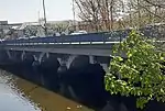
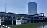 |
Lagan Bridge | 1995[1] | M3 Motorway | Concrete Box girder bridge[1] |
Not listed | Belfast | 54°36′09.6″N 5°55′11.0″W | Connects the Sydenham Bypass with the M2 foreshore. |
%252C_October_2009.JPG.webp) |
Dargan Bridge | 1995[1] | Belfast–Derry railway line Belfast–Larne railway line |
Concrete Box girder bridge[1] |
Not listed | Belfast | 54°36′08.8″N 5°55′12.0″W | Was built to connect all of Northern Ireland's railways into one network. |
 |
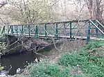
Lagan Weir Footbridge | 2015[2] | Pedestrians, cyclists | Steel Beam bridge |
Not listed | Belfast | 54°36′04.4″N 5°55′13.0″W | Replaced earlier bridge which was removed in 2014. |
%252C_October_2009.JPG.webp) |
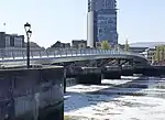
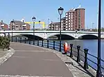
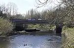
Queen Elizabeth Bridge | 1966[3] | A2 (eastbound) | Steel Girder bridge[4] |
Not listed | Belfast | 54°36′01.0″N 5°55′13.7″W | |
%252C_October_2009.JPG.webp) |
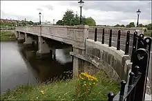
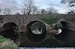
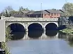
Queen's Bridge | 1843[5] | A2 (westbound) | Stone Arch bridge |
B+ | Belfast | 54°35′58.9″N 5°55′13.7″W | Replaced the earlier Long Bridge. Named after Queen Victoria. |
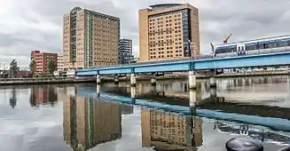 |
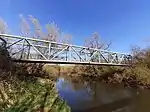
Lagan Railway Bridge | 1976[6] | Belfast–Derry railway line Belfast–Larne railway line Belfast–Bangor railway line pedestrians |
Steel Beam bridge |
Not listed | Belfast | 54°35′51.5″N 5°55′02.2″W | Replaced a single track, wooden bridge built in 1875 |
 |
Albert Bridge | 1890[7] | A20 East Bridge Street | Cast iron Arch bridge |
B+ | Belfast | 54°35′44.9″N 5°54′46.8″W | Replaced a previous bridge which suddenly collapsed. |
 |
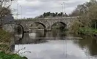
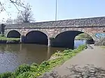
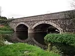
Ormeau Bridge | 1863[8] | A24 Ormeau Road | Stone Arch bridge |
Not listed | Belfast | 54°34′58.5″N 5°55′19.0″W | Replaced a previous bridge, built in 1809. |
 |
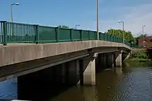
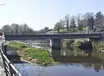
King's Bridge | 1912[9] | Eastbound road traffic | Concrete Beam bridge |
A | Belfast | 54°34′38.2″N 5°55′42.7″W | One of the first reinforced concrete bridges in Ireland. Named after King George V. |
 |
Governor's Bridge | 1974[10] | Westbound road traffic | Concrete Beam bridge |
Not listed | Belfast | 54°34′30.1″N 5°55′51.2″W | Named after Ralph Grey, Baron Grey of Naunton, the last Governor of Northern Ireland |
_-_geograph.org.uk_-_909089.jpg.webp) |
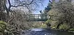
Stranmillis Weir | Private pedestrian access | Not listed | Belfast | 54°34′07.0″N 5°55′38.5″W | |||
.jpg.webp) |
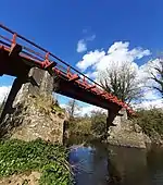
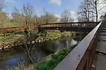
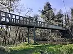
Lagan Gateway bridge | 2021[11] | Pedestrians and cyclists between Stranmillis and Annadale | Not listed | Belfast | 54°34′6.7″N 5°55′40.5″W | A new lock was also built under the bridge. The bridge will be named after Noah Donohoe.[12] | |
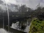 |
Brown Bridge or Belvoir Bridge[13][14] | 2023 | Pedestrians and cyclists between Belvoir Park Forest and Lagan Towpath | Wooden Arch bridge |
Not listed | Belfast | 54°33′27.4″N 5°56′10.4″W | Original bridge replaced in 2023 due to safety concerns.[15] |
 |
Red Bridge | Pedestrians and cyclists on Lagan Towpath National Cycle Route 9 | Iron Beam bridge |
Not listed | Belfast | 54°33′12.1″N 5°56′37.1″W | ||
 |
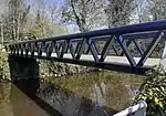
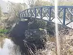
John Luke Bridge | 2013[16] | Pedestrians and cyclists on Lagan Towpath National Cycle Route 9 | Steel Butterfly bridge |
Not listed | Belfast | 54°33′17.7″N 5°56′57.1″W | Replaced earlier bridge. Named to honour Belfast-born artist John Luke |
_(geograph_3191407).jpg.webp) |
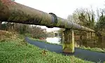
Water Main | Not listed | Belfast | 54°33′17.9″N 5°57′07.2″W | ||||
.JPG.webp) |
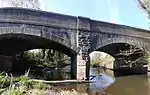
Shaw's Bridge (new) |
1977[17] | A55 Malone Road | Concrete Arch bridge |
Not listed | Belfast | 54°33′08.9″N 5°57′09.7″W | |
 |
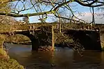
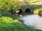
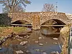
Shaw's Bridge (old) |
1707[17] | Pedestrians and cyclists | Stone Arch bridge |
B1 | Belfast | 54°33′08.1″N 5°57′10.8″W | Carried road traffic prior to the opening of its modern counterpart. Replaced a wooden bridge dating from the early 17th century [18] |
 |
Gilchrist Bridge | 1986 | Pedestrians and cyclists between Edenderry and Lagan Towpath | Wooden Arch bridge |
Not listed | Edenderry | 54°32′36.6″N 5°57′54.0″W | Named after John Gilchrist, founder of Lagan Valley Regional Park[18] |
 |
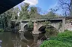
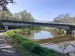
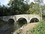
Drum Bridge | before 1832[18] |
B103 Upper Malone Road | Stone Arch bridge |
B1 | Drumbeg | 54°32′06.5″N 5°58′59.3″W | |
 |
Pedestrians and cyclists on Lagan Towpath National Cycle Route 9 | Truss bridge | Not listed | Drumbeg | 54°32′10.9″N 5°59′02.9″W | |||
 |
1962 | M1 Motorway | Concrete Box girder bridge |
Not listed | Drumbeg | 54°32′34.5″N 5°59′37.3″W | ||
| Private access to house | Not listed | Derriaghy | 54°32′20.3″N 6°00′12.5″W | |||||
 |
Rambler's Bridge[19] | Pedestrians and cyclists between Seymour Hill estate and Lagan Towpath | Truss bridge | Not listed | Derriaghy | 54°32′15.5″N 6°00′23.8″W | ||
 |
Wolfenden's Bridge | before 1833[18] |
B103 Ballyskeagh Road | Stone Arch bridge |
B+ | Lambeg | 54°32′00.0″N 6°01′02.7″W | |
 |
Lambeg Bridge | Tullynacross Road | Stone Arch bridge |
Not listed | Lambeg | 54°31′42.8″N 6°01′27.7″W | ||
 |
Pedestrians and cyclists | Steel Beam bridge |
Not listed | Lambeg | 54°31′42.5″N 6°01′28.0″W | |||
 |
Hilden Bridge | Bridge Street | Stone Arch bridge |
Not listed | Hilden | 54°31′18.8″N 6°01′19.3″W | ||
| Mid 1900s[20] | Single story building spanning the river on reinforced concrete beams | B+
(as part of mill complex) |
Hilden | 54°31′13.4″N 6°01′18.0″W | Gutted by fire in 2006 | |||
| Access within former Hilden Mill complex (bridge disused) | B+
(as part of mill complex) |
Hilden | 54°31′12.3″N 6°01′17.1″W | |||||
| 1896[21] | Pedestrians within former Hilden Mill complex (bridge disused) | Iron
Lattice girder bridge |
B2 | Hilden | 54°31′05.0″N 6°01′21.5″W | |||
_(geograph_2783392).jpg.webp) |
Private pedestrian access over weir | Not listed | Lisburn | 54°30′52.1″N 6°01′26.4″W | ||||
 |
Blue Bridge[14] | Pedestrians and cyclists | Concrete Cantilever bridge |
Not listed | Lisburn | 54°30′48.9″N 6°01′27.2″W | ||
 |
2002 | Pedestrian and cyclist access to Lagan Valley Island | Steel Truss bridge |
Not listed | Lisburn | 54°30′44.1″N 6°02′05.0″W | ||
 |
Queen's Bridge | 2002 | Road traffic access to Lagan Valley Island | Concrete Beam bridge |
Not listed | Lisburn | 54°30′42.3″N 6°02′11.6″W | |
 |
Union Bridge | 1880[18] | A49 Sloan Street | Stone Arch bridge |
Not listed | Lisburn | 54°30′35.8″N 6°02′17.6″W | Replaced earlier bridge |
 |
Water pipe | Not listed | Lisburn | 54°30′32.0″N 6°02′25.1″W | ||||
 |
Moore's Bridge | 1825[18] | A1 Hillsborough Road | Sandstone Arch bridge |
B1 | Lisburn | 54°29′55.6″N 6°03′08.2″W | |
 |
Pedestrians and cyclists on Lagan Towpath National Cycle Route 9 | Steel Arch bridge |
Not listed | Lisburn | 54°29′51.6″N 6°03′22.5″W | |||
_(geograph_4184032).jpg.webp) |
Young's Bridge | Halftown Road | Not listed | Lisburn | 54°30′01.4″N 6°05′50.8″W | |||
 |
Maze Bridge | Gravehill Road | Stone | Not listed | Mazetown | 54°29′42.3″N 6°06′58.4″W | ||
| The New Bridge | Cockhill Road | Not listed | Halfpenny Gate | 54°29′07.8″N 6°08′47.2″W | ||||
_-_geograph.org.uk_-_954314.jpg.webp) |
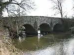
Spencer's Bridge | 1840-1859[22] | Hillsborough Road | Stone | B1 | Moira | 54°28′38.8″N 6°10′33.1″W | |
| M1 Motorway | Not listed | Moira | 54°28′35.5″N 6°11′22.0″W | |||||
.jpg.webp) |
Newmill Bridge | 1740-1759[23] | Clarehill Road | Stone | B2 | Moira | 54°28′26.8″N 6°12′20.9″W | |
| Steps Bridge | Steps Road | Not listed | Magheralin | 54°27′48.2″N 6°14′48.5″W | ||||
 |
Forge Bridge[24] | B9 New Forge Road | Stone | B2 | Magheralin | 54°27′31.5″N 6°15′34.2″W | ||
 |
Geehan's Bridge[25] | B2 Dromore Road | Stone | B1 | Waringstown | 54°26′41.1″N 6°16′21.6″W | ||
 |
Banoge Bridge[26] | Hall Road | Stone
Arch bridge |
B2 | Donaghcloney | 54°25′14.3″N 6°16′12.6″W | ||
.jpg.webp) |
Pedestrians to former Ewart Liddell Weaving Factory (bridge disused) | Not listed | Donaghcloney | 54°24′52.4″N 6°15′36.6″W | ||||
 |
Donaghcloney Bridge | B9 Main Street | Stone | Not listed | Donaghcloney | 54°24′55.9″N 6°15′24.3″W | ||
 |
Thornyford Bridge | 1760-1779[27] | Blackskull Road | Stone | B1 | Gamblestown | 54°25′18.5″N 6°12′54.6″W | |
| Gillhall Bridge | 1670s[28] | Private access to farm | Stone | B+ | Dromore | 54°25′00.0″N 6°12′11.4″W | Was built to provide access to Gill Hall mansion. The house was built at the same time as the bridge and was said to be haunted. It burnt down in 1969. | |
| Private access to farmland | Not listed | Dromore | 54°25′01.4″N 6°11′05.2″W | |||||
| Private access to B&B | Not listed | Dromore | 54°24′52.2″N 6°10′18.3″W | |||||
_(geograph_2614597).jpg.webp) |
1972[29] | A1 Dromore Bypass | Not listed | Dromore | 54°24′50.1″N 6°09′40.3″W | |||
_(geograph_2614510).jpg.webp) |
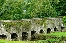
Dromore Viaduct | Early 1860s[30] | Trackbed of the former Banbridge, Lisburn and Belfast Junction Railway | Stone | B+ | Dromore | 54°24′49.2″N 6°09′38.7″W | Disused since the railway closed in 1956 |
| Pedestrians in Dromore Park | Not listed | Dromore | 54°24′45.3″N 6°09′31.6″W | |||||
| Pedestrians in Dromore Park | Not listed | Dromore | 54°24′46.3″N 6°09′26.3″W | |||||
.jpg.webp) |
Regent Bridge | 1811[31] | B2 Banbridge Road | Stone | B1 | Dromore | 54°24′51.4″N 6°09′04.7″W | |
| Downshire Bridge | 1885[32] | Bridge Street | Stone | B2 | Dromore | 54°24′50.3″N 6°08′58.7″W | ||
| Caughey's Road | Not listed | Dromore | 54°24′34.9″N 6°07′20.5″W | |||||
| Lurganbane Road | Not listed | Dromore | 54°24′21.4″N 6°05′49.1″W | |||||
| Lagangreen Bridge | Lagangreen Road | Not listed | Kinallen | 54°24′09.4″N 6°04′48.7″W | ||||
| 1800-1819[33] | Black Bog Road | Stone | B1 | Kinallen | 54°23′52.4″N 6°04′25.1″W | |||
| Kinallen Road | Not listed | Kinallen | 54°23′34.1″N 6°04′03.7″W | |||||
| Artanagh Road | Not listed | Kinallen | 54°23′11.5″N 6°02′42.6″W | |||||
| 1780- 1799[34] | Dromore Road | B2 | Dromara | 54°23′08.8″N 6°02′07.6″W | ||||
 |
1800-1819[35] | Banbridge Road | Stone | Not listed | Dromara | 54°22′47.9″N 6°01′12.9″W | ||
| Moybrick Road | Not listed | Dromara | 54°22′39.6″N 6°01′25.3″W | |||||
| Private access to farmland | Not listed | Dromara | 54°22′39.1″N 6°01′14.8″W | |||||
 |
Bell's Bridge | 1800-1819[36] | B7 Rathfriland Road | Stone | B2 | Dromara | 54°22′13.8″N 6°01′06.7″W | |
.jpg.webp) |
1800-1819[37] | Dree Hill (road) | Stone | Not listed | Finnis | 54°21′44.4″N 6°01′26.0″W | ||
| Private access to farm | Not listed | Finnis | 54°21′20.6″N 6°00′59.8″W | |||||
| Dree Hill (road) | Not listed | Finnis | 54°21′14.7″N 6°00′49.0″W | |||||
References
- "Belfast cross-harbour road and rail bridges". Institution of Civil Engineers (ICE). February 15, 2018.
- "£5m River Lagan pedestrian bridge opens in Belfast". Belfast Telegraph. Belfast. 30 June 2015. Retrieved 2020-06-20.
- "Meeting the Queen in Northern Ireland". BBC NI - Your Place and Mine. Retrieved 2021-04-01.
- "Girder bridges from around the world". Structurae.
- "Home | Buildings| nidirect". apps.communities-ni.gov.uk. Retrieved 2022-08-27.
- "Bridge%20Database.xls". docs.google.com.
- Central Belfast, A Historical Gazetteer, Ulster Architectural Heritage Society, 1993, p4
- "Geograph:: The Ormeau Bridge, Belfast [6 photos] in J34427251". www.geograph.org.uk.
- "Home | Buildings| nidirect". apps.communities-ni.gov.uk.
- "Geograph:: The Governor's Bridge, Belfast © Albert Bridge". www.geograph.ie.
- Lynch, Connor (2021-09-17). "Lagan Gateway bridge officially opens to the public". BelfastLive. Retrieved 2021-09-25.
- Kenwood, Michael (2022-08-19). "Belfast bridge set to be named after Noah Donohoe". BelfastLive. Retrieved 2022-08-27.
- McGonagle, Suzanne (2023-01-06). "No date for re-opening of pedestrian bridge along Lagan Towpath". The Irish News. Retrieved 2023-09-13.
- "The Lagan Towpath" (PDF). Lagan Valley Regional Park. Archived (PDF) from the original on 3 June 2021.
- "Council says opening of replacement pedestrian bridge on Lagan is imminent". BelfastTelegraph.co.uk. 2023-09-12. ISSN 0307-1235. Retrieved 2023-09-13.
- Limited, Alamy. "Stock Photo - John Luke Bridge". Alamy.
- "Geograph:: Shaw's Bridge, Belfast [46 photos] in J32566906". www.geograph.org.uk.
- "Bridges | Lagan Valley Regional Park". www.laganvalley.co.uk.
- "Lagan Navigation | Lagan Valley Regional Park". www.laganvalley.co.uk. Retrieved 2022-02-16.
- "Home | Buildings| nidirect". apps.communities-ni.gov.uk. Retrieved 2021-08-11.
- "Home | Buildings| nidirect". apps.communities-ni.gov.uk. Retrieved 2021-08-11.
- "Home | Buildings| nidirect". apps.communities-ni.gov.uk. Retrieved 2021-07-02.
- "Home | Buildings| nidirect". apps.communities-ni.gov.uk. Retrieved 2021-07-02.
- "Home | Buildings| nidirect". apps.communities-ni.gov.uk. Retrieved 2021-07-02.
- "Home | Buildings| nidirect". apps.communities-ni.gov.uk. Retrieved 2022-09-27.
- "Home | Buildings| nidirect". apps.communities-ni.gov.uk. Retrieved 2022-09-27.
- "Home | Buildings| nidirect". apps.communities-ni.gov.uk. Retrieved 2021-07-03.
- "Home | Buildings| nidirect". apps.communities-ni.gov.uk. Retrieved 2021-07-03.
- "A1 - Sprucefield to Beech Hill". www.wesleyjohnston.com. Retrieved 2021-07-04.
- "Home | Buildings| nidirect". apps.communities-ni.gov.uk. Retrieved 2021-07-04.
- "Home | Buildings| nidirect". apps.communities-ni.gov.uk. Retrieved 2021-07-04.
- "Home | Buildings| nidirect". apps.communities-ni.gov.uk. Retrieved 2021-07-04.
- "Home | Buildings| nidirect". apps.communities-ni.gov.uk. Retrieved 2021-07-04.
- "Home | Buildings| nidirect". apps.communities-ni.gov.uk. Retrieved 2022-09-27.
- "Home | Buildings| nidirect". apps.communities-ni.gov.uk. Retrieved 2021-07-04.
- "Home | Buildings| nidirect". apps.communities-ni.gov.uk. Retrieved 2021-07-04.
- "Home | Buildings| nidirect". apps.communities-ni.gov.uk. Retrieved 2021-07-04.
This article is issued from Wikipedia. The text is licensed under Creative Commons - Attribution - Sharealike. Additional terms may apply for the media files.