List of creeks of The Bahamas
This is a list of creeks of The Bahamas in alphabetical order for islands that have creeks. There is only one river in The Bahamas, the Goose River in Central Andros. There are also many tidal creeks, which resemble rivers.[1][2]
.jpg.webp)
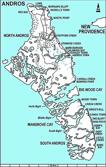
Andros Island
In March 2018, waves breaking over cliffs near the Glass Window Bridge in Eleuthera caused a flow of water across the island that washed out the Queens Highway, and was temporarily called a new river.[3]
Andros Island
The river and creeks on Andros Island include the following:[1][2]
| Name | Location |
|---|---|
| Cargill Creek | Central Andros, Cargill Cay |
| Deep Creek | North Andros, Deep Creek |
| Deep Creek | South Andros, 23.99164°N 77.53028°W[4] |
| Fresh Creek | North Andros, Fresh Creek |
| Goose River | Central Andros |
| Grassy Creek | South Andros, 23.79198°N 77.53418°W[5] |
| Hawk Creek | North Andros |
| Lisbon Creek | Mangrove Cay |
| Little Grassy Creek | South Andros |
| Loggerhead Creek | North Andros |
| Mount Creek | North Andros |
| Pelican Creek | North Andros |
| River Lees | North Andros, Fresh Creek |
| Sandy Creek | North Andros |
| Sapodilla Creek | North Andros |
| Simon Creek | North Andros |
| Somerset Creek | North Andros |
| Stafford Creek | North Andros, Stafford Creek, 24.89435°N 77.93692°W[6] |
| Staniard Creek | North Andros |
| Timber Creek | North Andros |
| Wide Opening | Fresh Creek, 24.41667°N 78.18333°W[7] |
Eleuthera Island
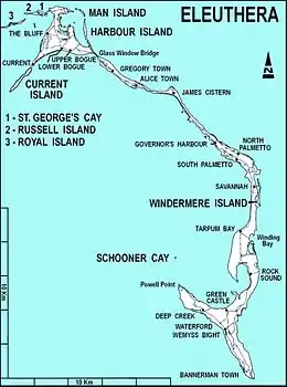
Eleuthera Island
There is one creek on Eleuthera Island. There is a town in South Eleuthera that is named Deep Creek.
Berry Islands
There is one known creek on Berry Islands:
- Stafford Creek, Berry Islands, 25.9°N 77.93333°W (??)[9]
Abaco Islands
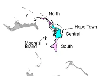
Abaco Islands
The Abaco Islands have following tidal creeks:
Mangrove Cay
- Miller Creek, 24.02071°N 77.83847°W[41]
Grand Bahama
There are one tidal creek and one channel in Grand Bahama:
- Thrift Harbor Creek, tidal creek, East Grand Bahama, 26.55°N 77.85°W[42]
- Hawksbill Creek, channel, West Grand Bahama, 26.53333°N 78.71667°W[43]
See also
References
- Maps and various GeoNames searches for each creek or river in the Bahamas.
- "GEONet Names Server". National Geospatial-Intelligence Agency. Retrieved June 25, 2021., GEOnet Names Server
- "Visit Glass Window Bridge, Eleuthera Island, the Bahamas". Trip Bucket. Retrieved July 9, 2021.
- "Deep Creek (South Andros)". GeoNames. Retrieved July 8, 2021.
- "Grassy Creek". GeoNames. Retrieved July 9, 2021.
- "Stafford Creek". GeoNames. Retrieved July 9, 2021.
- "Wide Opening". GeoNames. Retrieved July 9, 2021.
- "Starve Creek". GeoNames. Retrieved July 9, 2021.
- "Stafford Creek". GeoNames. Retrieved July 8, 2021.
- "Big Lake Creek". GeoNames. Retrieved July 9, 2021.
- "Big Mangrove Creek". GeoNames. Retrieved July 9, 2021.
- "Bill Bride Creek". GeoNames. Retrieved July 9, 2021.
- "Broad Creek". GeoNames. Retrieved July 9, 2021.
- "Calcutta Creek". GeoNames. Retrieved July 9, 2021.
- "Coconut Creek". GeoNames. Retrieved July 9, 2021.
- "Deals Creek". GeoNames. Retrieved July 9, 2021.
- "Don't Bluff Creek". GeoNames. Retrieved July 9, 2021.
- "Far Creek". GeoNames. Retrieved July 9, 2021.
- "First Creek". GeoNames. Retrieved July 9, 2021.
- "Fish Creek". GeoNames. Retrieved July 9, 2021.
- "Hills Creek". GeoNames. Retrieved July 9, 2021.
- "Hills Creek". GeoNames. Retrieved July 9, 2021.
- "Israel Creek". GeoNames. Retrieved July 9, 2021.
- "Joes's Creek". GeoNames. Retrieved July 9, 2021.
- "Little Creek". GeoNames. Retrieved July 9, 2021.
- "Loggerhead Creek". GeoNames. Retrieved July 9, 2021.
- "Mangrove Creek". GeoNames. Retrieved July 9, 2021.
- "Mangrove Creek". GeoNames. Retrieved July 9, 2021.
- "Mitchell Creek". GeoNames. Retrieved July 9, 2021.
- "Nigh Creek". GeoNames. Retrieved July 9, 2021.
- "Nimble Creek". GeoNames. Retrieved July 9, 2021.
- "Okra Creek". GeoNames. Retrieved July 9, 2021.
- "Sand Banks Harbour". GeoNames. Retrieved July 9, 2021.
- "Second Creek". GeoNames. Retrieved July 9, 2021.
- "Senacord Creek". GeoNames. Retrieved July 9, 2021.
- "Treasure Cay Creek". GeoNames. Retrieved July 9, 2021.
- "Turtle Creek". GeoNames. Retrieved July 9, 2021.
- "Wallace Creek". GeoNames. Retrieved July 9, 2021.
- "Wills Cay Creek". GeoNames. Retrieved July 9, 2021.
- "Wills Creek". GeoNames. Retrieved July 9, 2021.
- "Miller Creek". GeoNames. Retrieved July 9, 2021.
- "Thrift Harbor Creek". GeoNames. Retrieved July 10, 2021.
- "Hawksbill Creek". GeoNames. Retrieved July 9, 2021.
- Water Resources Assessment of the Bahamas (PDF). US Army Corps of Engineers. 2004. Retrieved July 9, 2021.
This article is issued from Wikipedia. The text is licensed under Creative Commons - Attribution - Sharealike. Additional terms may apply for the media files.