List of hillside letters in Arizona

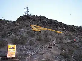
This is a list of hillside letters (also known as mountain monograms) in the U.S. state of Arizona.[1][2][3] There are at least 63 hillside letters, acronyms, and messages in the state, possibly more. Arizona's most notable monograms are likely the pair of A's for Arizona State University and the University of Arizona that are a focus of their rivalry. Arizona also has a fictional monogram, the RS for Radiator Springs in the movie Cars.

MonogramTownDescriptionLocationPicture
AAjo32.3654°N 112.8766°W / 32.3654; -112.8766 (Ajo) IMG_4695
ATacnaAntelope Union High School32.7012°N 114.0125°W / 32.7012; -114.0125 (Antelope Union High School)
ATempeArizona State University, 1918 (N), 1925 (T), 1938 (A)33.4279°N 111.936°W / 33.4279; -111.936 (Arizona State University)
ATucsonConstructed on Sentinel Peak by University of Arizona students in 1916.32.2106°N 110.9917°W / 32.2106; -110.9917 (University of Arizona)
AFAsh Fork35.2329°N 112.4773°W / 35.2329; -112.4773 (Ash Fork)
BBagdad34.5806°N 113.1802°W / 34.5806; -113.1802 (Bagdad)
BBisbee31.4442°N 109.9107°W / 31.4442; -109.9107 (Bisbee)
BBouse33.9418°N 113.9949°W / 33.9418; -113.9949 (Bouse)
BSandersSanders Middle School Braves35.2207°N 109.3283°W / 35.2207; -109.3283 (Sanders Middle School Braves)
CGCasa Grande32.8277°N 111.7211°W / 32.8277; -111.7211 (Casa Grande)
CChinle36.15576°N 109.62497°W / 36.15576; -109.62497 (Chinle)
CChloride35.419°N 114.1885°W / 35.419; -114.1885 (Chloride)
CClarkdale34.7831°N 112.0666°W / 34.7831; -112.0666 (Clarkdale)
CClifton33.0435°N 109.3001°W / 33.0435; -109.3001 (Clifton)
CConcho34.4753°N 109.5956°W / 34.4753; -109.5956 (Concho)
CCoolidge33.0644°N 111.5146°W / 33.0644; -111.5146 (Coolidge)
CCottonwood34.7307°N 112.0268°W / 34.7307; -112.0268 (Cottonwood)
DILKONDilkon35.3835°N 110.3234°W / 35.3835; -110.3234 (Dilkon)
DSDolan Springs35.5843°N 114.2859°W / 35.5843; -114.2859 (Dolan Springs)
DDouglas31.3467°N 109.4777°W / 31.3467; -109.4777 (Douglas)
DDuncan32.7252°N 109.1116°W / 32.7252; -109.1116 (Duncan)
EFGoodyearEstrella Foothills High School33.3370124°N 112.4082473°W / 33.3370124; -112.4082473 (Estrella Foothills)
FFlorence33.0545°N 111.4082°W / 33.0545; -111.4082 (Florence)
TFort Thomas33.0702°N 109.9453°W / 33.0702; -109.9453 (Fort Thomas)
FFredonia36.9781°N 112.525°W / 36.9781; -112.525 (Fredonia)
GGanado35.7137°N 109.5303°W / 35.7137; -109.5303 (Ganado)
GThe Gap36.3195°N 111.464°W / 36.3195; -111.464 (The Gap)
GGlobe33.3944°N 110.7899°W / 33.3944; -110.7899 (Globe)
HALLSpringervilleHall Trucking & Materials34.1047°N 109.2408°W / 34.1047; -109.2408 (Hall Ranch?)
HHaydenHayden High School32.9934°N 110.774°W / 32.9934; -110.774 (Hayden High School)
H (no longer exists)Holbrook34.9092°N 110.1726°W / 34.9092; -110.1726 (Holbrook)
JJerome34.7487°N 112.1192°W / 34.7487; -112.1192 (Jerome)
JCJoseph City34.9654°N 110.3179°W / 34.9654; -110.3179 (Joseph City)
KKayenta36.7374°N 110.2613°W / 36.7374; -110.2613 (Kayenta)
KKingman35.1961°N 114.0549°W / 35.1961; -114.0549 (Kingman)
LLaveen33.3458°N 112.1652°W / 33.3458; -112.1652 (Laveen)
MMaricopa33.1455°N 112.0192°W / 33.1455; -112.0192 (Maricopa)
MMayer34.3979°N 112.2383°W / 34.3979; -112.2383 (Mayer) (uncertain location)
MMiami33.397°N 110.8765°W / 33.397; -110.8765 (Miami)
MMorenci33.0402°N 109.3211°W / 33.0402; -109.3211 (Morenci)
PPage36.8815°N 111.4905°W / 36.8815; -111.4905 (Page)
PParker34.1234°N 114.2217°W / 34.1234; -114.2217 (Parker)
PPrescott34.541°N 112.429°W / 34.541; -112.429 (Prescott)
<PHOENIXMesa33.492°N 111.63°W / 33.492; -111.63 (Mesa)
QQuartzsite33.6523°N 114.2303°W / 33.6523; -114.2303 (Quartzsite)
RKearnyRay High School33.0499°N 110.9314°W / 33.0499; -110.9314 (Ray High School)
RVEagarRound Valley High School34.1198°N 109.2803°W / 34.1198; -109.2803 (Round Valley High School)
SSalome33.7653°N 113.5574°W / 33.7653; -113.5574 (Salome)
SDSeba Dalkai35.4855°N 110.4538°W / 35.4855; -110.4538 (Seba Dalkai)
SSeligman35.3683°N 112.8989°W / 35.3683; -112.8989 (Seligman)
SSnowflake34.5246°N 110.08833°W / 34.5246; -110.08833 (Snowflake)
SJSt. Johns34.5082°N 109.2965°W / 34.5082; -109.2965 (St. Johns)
SPhoenixSunnyslope High School33.5739°N 112.0766°W / 33.5739; -112.0766 (Sunnyslope High School)
SSuperior33.2818°N 111.0958°W / 33.2818; -111.0958 (Superior)
TTempe33.407°N 111.9672°W / 33.407; -111.9672 (Tempe)
TPhoenixThunderbird High School33.6151°N 112.0965°W / 33.6151; -112.0965 (Thunderbird High School)
TTombstone31.7194°N 110.0737°W / 31.7194; -110.0737 (Tombstone)
TEEC NOS POSTeec Nos Pos36.9347°N 109.0911°W / 36.9347; -109.0911 (Teec Nos Pos)
VElfridaValley Union High School31.6979°N 109.5714°W / 31.6979; -109.5714 (Valley Union High School)
WWickenburg33.981°N 112.7192°W / 33.981; -112.7192 (Wickenburg)
WWillcox32.3465°N 109.8395°W / 32.3465; -109.8395 (Willcox)
WRFort DefianceWindow Rock High School35.7262°N 109.0743°W / 35.7262; -109.0743 (Window Rock High School)
WWoodruff34.7967°N 110.0421°W / 34.7967; -110.0421 (Woodruff)
YYarnell34.2218°N 112.7414°W / 34.2218; -112.7414 (Yarnell)

Tucson's "A" Mountain
The A on Tempe Butte for Arizona State University

References

  1. Corning, Evelyn (2007). Hillside Letters A to Z : A Guide to Hometown Landmarks. Missoula, Mont.: Mountain Press Publishing Company.
  2. Rocha, Guy (June 2004), "Hillside Letters: In Plain Sight But Not Intended for Planes", Sierra Sage, archived from the original on 2011-07-22, retrieved 2011-08-09
  3. Parsons, James J. (1988). "Hillside Letters in the Western United States". Landscape. Santa Fe, N.M. 30 (1): 15–23. Retrieved 2011-08-09.
This article is issued from Wikipedia. The text is licensed under Creative Commons - Attribution - Sharealike. Additional terms may apply for the media files.