List of historic places in Côte-Nord
This article is a list of historic places in Côte-Nord, entered on the Canadian Register of Historic Places, whether they are federal, provincial, or municipal. All addresses are the administrative Region 09. For all other listings in the province of Quebec, see List of historic places in Quebec.
| Name | Address | Coordinates | Government recognition (CRHP №) | Image | |
|---|---|---|---|---|---|
| Chapelle de Tadoussac | Rue du Bord-de-l'Eau Tadoussac QC |
48°08′30″N 69°42′55″W | Quebec (12432) | 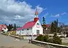 More images | |
| Wreck of the Elizabeth and Mary National Historic Site of Canada | L'Anse-aux-Bouleaux Baie-Trinité QC |
49°23′00″N 67°18′57″W | Federal (15926) |  Upload Photo | |
| Église de Sainte-Amélie | 37, Avenue Marquette Baie-Comeau QC |
49°13′09″N 68°08′51″W | Quebec (13799) |  More images | |
| La Petite Anglicane de Forestville | 2e Rue Forestville QC |
48°44′14″N 69°04′13″W | Forestville municipality (8493) | Upload Photo | |
| Site du patrimoine de Sacré-Coeur | Sacre-Coeur QC |
48°13′58″N 69°48′06″W | Sacre-Coeur municipality (10334) | 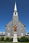 More images | |
| Site archéologique des Basques-de-l'Anse-à-la-Cave | Les Bergeronnes QC |
48°17′07″N 69°26′00″W | Quebec (12464) | Upload Photo | |
| Sites archéologiques de la Pointe-à-John | Rue de la Mer Les Bergeronnes QC |
48°13′46″N 69°33′02″W | Quebec (12932) |  | |
| Église de Sainte-Anne | Rue de Monseigneur-Bouchard Portneuf-sur-Mer QC |
48°37′04″N 69°06′01″W | Portneuf-sur-Mer municipality (13255) | 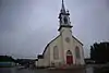 | |
| Arboriduc | Forestville QC |
48°44′21″N 69°03′37″W | Forestville municipality (14411) |  | |
| Maison Johan-Beetz | Route 138 Baie-Johan-Beetz QC |
50°17′20″N 62°48′21″W | Quebec (9371) | 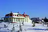 More images | |
| Arrondissement naturel de l'Archipel-de-Mingan | Havre-Saint-Pierre QC |
50°12′10″N 63°28′47″W | Quebec (10225) |  | |
| Église Sainte-Anne de l'île Providence | Cote-Nord-du-Golfe-du-Saint-Laurent QC |
50°37′01″N 59°13′41″W | Cote-Nord-du-Golfe-du-Saint-Laurent municipality (11976) | Upload Photo | |
| Site historique des Galets | Natashquan QC |
50°10′54″N 61°49′24″W | Quebec (12391) | 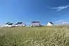 | |
| Site historique de Room's Point | Blanc-Sablon QC |
51°25′29″N 57°08′17″W | Quebec (12442) | 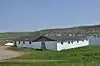 | |
| Four à chaux de Baie-Sainte-Claire | L'Ile-d'Anticosti QC |
49°53′53″N 64°29′32″W | Quebec (13057) | Upload Photo | |
| Site archéologique de l'Île-au-Bois | Blanc-Sablon QC |
51°23′57″N 57°09′16″W | Quebec (13396) | 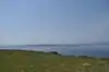 | |
| Blanc-Sablon National Historic Site of Canada | Blanc-Sablon QC |
51°25′39″N 57°08′00″W | Federal (15814), Quebec (13434) |
 More images | |
| Site archéologique du Poste-de-Nétagamiou | Cote-Nord-du-Golfe-du-Saint-Laurent QC |
50°28′47″N 59°35′13″W | Quebec (13805) | Upload Photo | |
| Phare de Pointe-des-Monts | Baie-Trinite QC |
49°19′32″N 67°22′00″W | Quebec (9366) | 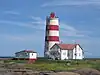 More images | |
| Corossol | Sept-Îles QC |
50°05′37″N 66°23′29″W | Federal (15957) | Upload Photo | |
| Light Tower | Central south coast of Anticosti Isle Bagot Bluff QC |
49°23′29″N 63°35′42″W | Federal (10890) | Upload Photo | |
| Light Tower | Northeast coast of Anticosti Isle Cap de la Table QC |
49°21′03″N 61°53′47″W | Federal (10949) | Upload Photo | |
| Light Tower | Northwest coast of Anticosti Isle Cap de Rabast QC |
49°57′05″N 64°09′00″W | Federal (10948) | Upload Photo | |
| Light Tower | North central coast of Anticosti Isle Cap de Rabast QC |
49°43′52″N 62°56′33″W | Federal (10893) | Upload Photo | |
| Île aux Perroquets Lighthouse | Western end of the Mingan Islands Archipelago Longue-Pointe-de-Mingan QC |
50°13′14″N 64°12′23″W | Federal (20714) | 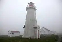 | |
| Haut-Fond-Prince Lighttower | On a caisson in the Saint Lawrence River Tadoussac QC |
48°07′26″N 69°40′16″W | Federal (21069) | 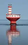 |
See also
This article is issued from Wikipedia. The text is licensed under Creative Commons - Attribution - Sharealike. Additional terms may apply for the media files.