List of historic places in Sunbury County, New Brunswick
This article is a list of historic places in Sunbury County, New Brunswick entered on the Canadian Register of Historic Places, whether they are federal, provincial, or municipal.
List of historic places
| Name | Address | Coordinates | Government recognition (CRHP №) | Image | |
|---|---|---|---|---|---|
| Belmont House / R. Wilmot Home National Historic Site of Canada | Lincoln Road (NB Route 102) Lincoln NB |
45°54′49″N 66°35′14″W | Federal (1192) |  Upload Photo | |
| George Brown House | 325 MacDonald Avenue Oromocto NB |
45°50′56″N 66°29′00″W | Oromocto municipality (18391) | Upload Photo | |
| Building 2 | Acadia Forest Experimental Station Maugerville NB |
46°09′59″N 66°17′00″W | Federal (4368) | Upload Photo | |
| Building 8 | Acadia Forest Experimental Station Maugerville NB |
46°10′01″N 66°17′00″W | Federal (4371) | Upload Photo | |
| Building 10 | Acadia Forest Experimental Station Maugerville NB |
46°10′00″N 66°17′00″W | Federal (4373) | Upload Photo | |
| Building 11 | Acadia Forest Experimental Station Maugerville NB |
46°10′00″N 66°17′00″W | Federal (4372) | Upload Photo | |
| Building 12 | Acadia Forest Experimental Station Maugerville NB |
46°10′00″N 66°17′01″W | Federal (4369) | Upload Photo | |
| Building 15 | Acadia Forest Experimental Station Maugerville NB |
45°55′N 66°20′W | Federal (3152) | Upload Photo | |
| Burpee-Bridges House | 2111 Rt. 105. Sheffield NB |
45°53′07″N 66°21′35″W | New Brunswick (5837) | Upload Photo | |
| Christ Church Anglican National Historic Site of Canada | Maugerville NB |
45°52′17″N 66°26′47″W | Federal (12026) | Upload Photo | |
| Oromocto Cenotaph | MacDonald Avenue Oromocto NB |
45°51′03″N 66°28′27″W | Oromocto municipality (18392) | Upload Photo | |
| St. John's Anglican Church and Graveyard | 60 Broad Road Oromocto NB |
45°50′59″N 66°28′21″W | Oromocto municipality (18389) | Upload Photo | |
| Wolastoq National Historic Site of Canada | Entire watershed of Saint John River central and western New Brunswick, parts of southeastern Quebec NB |
45°51′47″N 66°27′22″W | Federal (18954) | 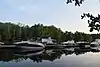 More images |
See also
This article is issued from Wikipedia. The text is licensed under Creative Commons - Attribution - Sharealike. Additional terms may apply for the media files.