List of listed buildings in Arisaig and Moidart
List
| Name | Location | Date Listed | Grid Ref. [note 1] | Geo-coordinates | Notes | LB Number [note 2] | Image |
|---|---|---|---|---|---|---|---|
| Polnish, Our Lady Of The Braes Roman Catholic Church | 56°52′55″N 5°41′34″W | Category B | 43375 |  Upload Photo | |||
| Kinlochmoidart, Low Farm House | Kinlochmoidart | 56°47′24″N 5°45′13″W | Category C(S) | 289 | Upload Photo | ||
| Polnish, Arnabol Railway Viaduct Over Arnabol Burn | 56°53′20″N 5°42′51″W | Category B | 297 | 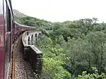
| |||
| Roshven House Roshven, Including Courtyard Buildings, Garden Walls And Sundial | 56°50′37″N 5°45′47″W | Category B | 301 | Upload Photo | |||
| Kinlochmoidart, Episcopal Church Of St Finnan | Kinlochmoidart | 56°47′25″N 5°45′03″W | Category C(S) | 316 | Upload Photo | ||
| Kinlochmoidart House | Kinlochmoidart | 56°47′13″N 5°44′26″W | Category A | 317 | .jpg.webp)
| ||
| Arisaig Railway Station, Ticket Office/Waiting Room And Signal Box | Arisaig | 56°54′46″N 5°50′23″W | Category B | 326 | .jpg.webp)
| ||
| Arisaig Village, Roman Catholic Church Of St Mary, Kilmory | Arisaig | 56°54′52″N 5°50′50″W | Category C(S) | 328 | Upload Photo | ||
| Arisaig Village, Old Church And Burial Ground | Arisaig | 56°54′51″N 5°50′52″W | Category B | 329 | Upload Photo | ||
| Arisaig, Arisaig House And Garden Walls | 56°53′51″N 5°47′32″W | Category B | 330 | Upload Photo | |||
| Arisaig, Borrodale House | 56°53′56″N 5°47′15″W | Category B | 332 | Upload Photo | |||
| Kinlochmoidart, Kinacarra (Former School And Schoolhouse | Kinlochmoidart | 56°47′23″N 5°46′03″W | Category B | 291 | Upload Photo | ||
| Shiel Bridge, Old Bridge Over River Shiel | 56°45′22″N 5°48′24″W | Category B | 300 | Upload Photo | |||
| Glenfinnan Barn And Steading | 56°52′12″N 5°26′52″W | Category B | 311 | Upload Photo | |||
| Arisaig Village, High Land, 1-8 New Street | Arisaig | 56°54′38″N 5°50′28″W | Category B | 324 | Upload Photo | ||
| Arisaig Village, Roman Catholic Church Of St Mary And Presbytery (Chapel House) | Arisaig | 56°54′53″N 5°50′53″W | Category C(S) | 327 | Upload Photo | ||
| Loch Nam Uamh Railway Viaduct Over Gleann Mama | 56°53′33″N 5°43′50″W | Category B | 295 | 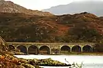
| |||
| Arisaig, Faire-Na-Sgurr | 56°54′05″N 5°50′51″W | Category B | 303 | Upload Photo | |||
| Eilean Fhianain, St Finnan's Chapel And Burial Ground | 56°45′07″N 5°40′42″W | Category A | 306 | .jpg.webp)
| |||
| Kinlochmoidart House, West Lodge Gatepiers And Flanking Walls | Kinlochmoidart | 56°47′10″N 5°44′53″W | Category B | 319 | Upload Photo | ||
| Arisaig Village, Church Of Scotland Manse | Arisaig | 56°54′41″N 5°50′35″W | Category C(S) | 323 | Upload Photo | ||
| Arisaig, Borrodale House Steading | 56°53′57″N 5°47′15″W | Category B | 333 | Upload Photo | |||
| Arisaig, Borrodale Railway Viaduct Over The Borrodale Burn | 56°54′12″N 5°46′59″W | Category A | 302 | 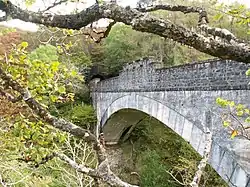
| |||
| Back Of Keppoch, Barn/Byre And Stable, Sunnymead | 56°55′27″N 5°51′19″W | Category B | 304 | Upload Photo | |||
| Glenfinnan, Roman Catholic Church Of Our Lady And St Finnan And Belfry | 56°52′17″N 5°26′30″W | Category B | 309 | 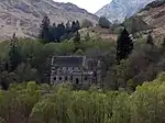
| |||
| Kinlochmoidart, Ardmolich Bridge Over River Moidart | Kinlochmoidart | 56°47′02″N 5°44′45″W | Category B | 314 | Upload Photo | ||
| Arisaig Village, Astley Hall | Arisaig | 56°54′37″N 5°50′31″W | Category B | 320 | Upload Photo | ||
| Arisaig Village, Arisaig Church Primary School | Arisaig | 56°54′40″N 5°50′33″W | Category C(S) | 321 | Upload Photo | ||
| Arisaig Village, Church Of Scotland | Arisaig | 56°54′41″N 5°50′34″W | Category B | 322 | Upload Photo | ||
| Kinlochmoidart, Low Farm Steading | Kinlochmoidart | 56°47′23″N 5°45′16″W | Category B | 290 | Upload Photo | ||
| Larichmore Road Bridge Over Brunery Burn | 56°54′44″N 5°49′18″W | Category C(S) | 293 | Upload Photo | |||
| Larichmore Railway Viaduct Over Brunery Burn | 56°54′44″N 5°49′18″W | Category B | 292 | 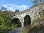
| |||
| Shiel Bridge, Fishing Station By Dorlin, Store/Fish-House And Pier | 56°46′27″N 5°49′44″W | Category C(S) | 298 | Upload Photo | |||
| Castle Tiorim (Eilean Tiorim) | 56°47′04″N 5°49′45″W | Category A | 305 | 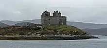
| |||
| Glenfinnan Monument | Glenfinnan | 56°52′09″N 5°26′13″W | Category A | 308 | 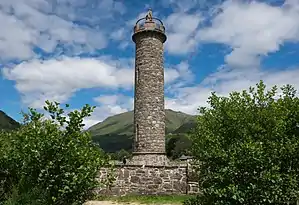
| ||
| Glenfinnan Railway Viaduct Over River Finnan | Glenfinnan | 56°52′35″N 5°25′54″W | Category A | 310 | 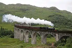
| ||
| Glenfinnan Railway Station, Ticket Office/Waiting Room and Signal Box | Glenfinnan | 56°52′21″N 5°26′59″W | Category B | 312 | 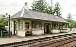
| ||
| Kinlochmoidart, Brunery Old Bridge | Kinlochmoidart | 56°46′57″N 5°43′12″W | Category C(S) | 315 | Upload Photo | ||
| Arisaig Village, Keppoch House | Arisaig | 56°54′44″N 5°51′12″W | Category B | 325 | Upload Photo | ||
| Arisaig, Arisaig House Gardener's Bothy | 56°53′53″N 5°47′25″W | Category B | 331 | Upload Photo | |||
| Morar, Falls Of Morar Railway Viaduct Over River Morar | 56°57′47″N 5°48′57″W | Category B | 296 | Upload Photo | |||
| Eilean Shona House (By Acharacle) | 56°47′21″N 5°50′27″W | Category C(S) | 307 | Upload Photo | |||
| Glenuig Post Office | 56°49′35″N 5°49′08″W | Category B | 313 | Upload Photo | |||
| Kinlochmoidart House, East Lodge | Kinlochmoidart | 56°47′05″N 5°44′13″W | Category B | 318 | Upload Photo | ||
| Roshven Estate, The Square | 56°50′33″N 5°45′26″W | Category C(S) | 43852 | Upload Photo | |||
| Loch Shiel, Howard Memorial | 56°45′14″N 5°41′41″W | Category C(S) | 294 | Upload Photo | |||
| Shiel Bridge Road Bridge Over River Shiel | 56°45′13″N 5°48′06″W | Category B | 299 | Upload Photo |
Key
The scheme for classifying buildings in Scotland is:
- Category A: "buildings of national or international importance, either architectural or historic; or fine, little-altered examples of some particular period, style or building type."[1]
- Category B: "buildings of regional or more than local importance; or major examples of some particular period, style or building type, which may have been altered."[1]
- Category C: "buildings of local importance; lesser examples of any period, style, or building type, as originally constructed or moderately altered; and simple traditional buildings which group well with other listed buildings."[1]
In March 2016 there were 47,288 listed buildings in Scotland. Of these, 8% were Category A, and 50% were Category B, with the remaining 42% being Category C.[2]
See also
Notes
- Sometimes known as OSGB36, the grid reference (where provided) is based on the British national grid reference system used by the Ordnance Survey.
• "Guide to National Grid". Ordnance Survey. Retrieved 12 December 2007.
• "Get-a-map". Ordnance Survey. Retrieved 17 December 2007. - Historic Environment Scotland assign a unique alphanumeric identifier to each designated site in Scotland, for listed buildings this always begins with "LB", for example "LB12345".
References
- All entries, addresses and coordinates are based on data from Historic Scotland. This data falls under the Open Government Licence
- "What is Listing?". Historic Environment Scotland. Retrieved 29 May 2018.
- Scotland's Historic Environment Audit 2016 (PDF). Historic Environment Scotland and the Built Environment Forum Scotland. pp. 15–16. Retrieved 29 May 2018.
This article is issued from Wikipedia. The text is licensed under Creative Commons - Attribution - Sharealike. Additional terms may apply for the media files.