List of listed buildings in Bellie, Moray
List
| Name | Location | Date Listed | Grid Ref. [note 1] | Geo-coordinates | Notes | LB Number [note 2] | Image |
|---|---|---|---|---|---|---|---|
| Gordon Castle Farm, Farm Cottages | 57°37′05″N 3°05′01″W | Category B | 1624 | .jpg.webp)
| |||
| Gordon Castle Gardens, Large And Small Walled Gardens | 57°37′02″N 3°05′34″W | Category B | 1626 | .jpg.webp)
| |||
| Chapelford, St Ninian's Burial Ground, Chapel And Dawson Mausoleum | 57°37′33″N 3°01′15″W | Category B | 1544 | .jpg.webp)
| |||
| Fochabers, 79 High Street, Bank Of Scotland | 57°36′52″N 3°05′56″W | Category B | 1546 |  Upload Photo | |||
| Fochabers, 81, High Street | 57°36′53″N 3°05′56″W | Category C(S) | 1547 | Upload Photo | |||
| Fochabers, 13, 15 East Street | 57°36′45″N 3°05′37″W | Category B | 1555 | Upload Photo | |||
| Fochabers, 4, 6, George Street | 57°36′50″N 3°05′55″W | Category C(S) | 1557 | Upload Photo | |||
| Fochabers, 29, 31 High Street | 57°36′48″N 3°05′40″W | Category C(S) | 1564 | Upload Photo | |||
| Fochabers, 41, 43 High Street | 57°36′48″N 3°05′43″W | Category C(S) | 1565 | Upload Photo | |||
| Fochabers, 2, 4, 6 Maxwell Street | 57°36′49″N 3°05′35″W | Category C(S) | 1577 | Upload Photo | |||
| Fochabers, South Street, Roman Catholic Church And Presbytery | 57°36′46″N 3°05′43″W | Category B | 1581 | Upload Photo | |||
| Fochabers, 8, 10 The Square | 57°36′52″N 3°05′48″W | Category B | 1586 | Upload Photo | |||
| Fochabers, West Street Garden Wall Fronting Ben Aliskay, But Not Including House | 57°36′56″N 3°05′56″W | Category B | 1593 | Upload Photo | |||
| Gordon Castle, Mansion House, Gatepiers And Conservatory/Orangery | 57°37′17″N 3°05′19″W | Category A | 1595 | Upload Photo | |||
| Fochabers, 15 And 15A The Square And Gardens Walls Facing The Square, George Street And Spey Street | 57°36′51″N 3°05′54″W | Category B | 1619 | Upload Photo | |||
| 22 Bogmuir | 57°39′06″N 3°04′44″W | Category C(S) | 1541 | Upload Photo | |||
| Fochabers, By Cricket Field, Fountain | 57°36′57″N 3°06′08″W | Category C(S) | 1551 | .jpg.webp)
| |||
| Fochabers, 3, 5 Duke Street And Garden Walls | 57°36′54″N 3°05′49″W | Category B | 1553 | Upload Photo | |||
| Fochabers, 69 High Street | 57°36′50″N 3°05′49″W | Category B | 1566 | Upload Photo | |||
| Fochabers, 38, 40 High Street | 57°36′49″N 3°05′41″W | Category C(S) | 1567 | Upload Photo | |||
| Fochabers, 54, 54A High Street | 57°36′50″N 3°05′45″W | Category C(S) | 1571 | Upload Photo | |||
| Fochabers, 78 High Street Gordon Arms Hotel Including West Street And Gordon Street Elevations | 57°36′54″N 3°05′57″W | Category B | 1575 | Upload Photo | |||
| Fochabers, 42 South Street, South View | 57°36′47″N 3°05′50″W | Category B | 1582 | Upload Photo | |||
| Fochabers, 2 Castle Street, East Lodge And Garden Wall | 57°36′50″N 3°05′33″W | Category A | 1584 | Upload Photo | |||
| Gordon Castle, Home Farm Steading (Former Stables/Carriage House) | 57°37′17″N 3°05′28″W | Category B | 1620 | Upload Photo | |||
| Gordon Castle Gardens, Lakeside House | 57°37′05″N 3°05′41″W | Category A | 1628 | .jpg.webp)
| |||
| Gordon Castle, Quarry Gardens Lodge | 57°37′39″N 3°04′51″W | Category B | 1630 | .jpg.webp)
| |||
| Gordon Castle, Whitegate Lodge And Outbuildings | 57°36′49″N 3°04′33″W | Category B | 1631 | .jpg.webp)
| |||
| Fochabers, 10 Gordon Street And Garden Walls | 57°36′54″N 3°05′54″W | Category B | 1559 | Upload Photo | |||
| Fochabers, High Street, Milne's High School And Enclosing Walls With Gatepiers | 57°36′41″N 3°05′30″W | Category A | 1560 | 
| |||
| Fochabers, The Old Manse | 57°36′40″N 3°05′53″W | Category B | 1580 | Upload Photo | |||
| Fochabers, 14 The Square And 1 Duke Street | 57°36′53″N 3°05′50″W | Category C(S) | 1588 | Upload Photo | |||
| Fochabers, War Memorial | 57°36′58″N 3°06′07″W | Category B | 1592 | .jpg.webp)
| |||
| Tugnet Ice House | 57°40′24″N 3°05′33″W | Category A | 1605 | 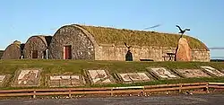
| |||
| Tugnet, Tugnet Cottage And Steading | 57°40′24″N 3°05′31″W | Category B | 1606 | Upload Photo | |||
| Tynet, Roman Catholic Chapel Of St Ninian | 57°38′13″N 3°02′31″W | Category A | 1609 | .jpg.webp)
| |||
| Fochabers, 1, 3 The Square | 57°36′50″N 3°05′49″W | Category B | 1613 | Upload Photo | |||
| Fochabers, 5 The Square | 57°36′50″N 3°05′50″W | Category C(S) | 1614 | Upload Photo | |||
| Fochabers, The Square, Bellie Kirk (Church Of Scotland) | 57°36′50″N 3°05′52″W | Category A | 1616 | 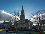
| |||
| Speymouth Forest, Whiteash Cairn | 57°36′11″N 3°03′02″W | Category C(S) | 1634 | .jpg.webp)
| |||
| 19 Bogmuir | 57°39′06″N 3°04′46″W | Category B | 1542 | Upload Photo | |||
| Byres Farmhouse | 57°38′45″N 3°04′51″W | Category B | 1543 | Upload Photo | |||
| Fochabers, Castle Street, Park Wall Fronting Gordon Castle Park Between Angle With West Street And Gordon Chapel | 57°36′55″N 3°06′04″W | Category B | 1550 | Upload Photo | |||
| Fochabers, 9, 11 East Street | 57°36′46″N 3°05′37″W | Category C(S) | 1554 | Upload Photo | |||
| Fochabers, 2, 4, 6 East Street | 57°36′50″N 3°05′34″W | Category C(S) | 1556 | Upload Photo | |||
| Fochabers, 8 George Street | 57°36′50″N 3°05′56″W | Category B | 1558 | Upload Photo | |||
| Fochabers, 42 High Street, Grant Arms Hotel | 57°36′49″N 3°05′42″W | Category C(S) | 1568 | Upload Photo | |||
| Fochabers, 46 High Street | 57°36′49″N 3°05′44″W | Category C(S) | 1569 | Upload Photo | |||
| Fochabers, 50, 50A, 52 High Street, Clydesdale Bank | 57°36′50″N 3°05′45″W | Category B | 1570 | Upload Photo | |||
| Fochabers, 56 High Street | 57°36′50″N 3°05′46″W | Category C(S) | 1572 | Upload Photo | |||
| 32 Maxwell Street | 57°36′52″N 3°05′45″W | Category C(S) | 1578 | Upload Photo | |||
| Fochabers, 46 South Street | 57°36′48″N 3°05′52″W | Category B | 1583 | Upload Photo | |||
| Fochabers, 12 The Square And Return Wing To Duke Street | 57°36′52″N 3°05′49″W | Category B | 1587 | Upload Photo | |||
| Fochabers, 87 And 89 High Street | 57°36′53″N 3°05′59″W | Category C(S) | 1599 | Upload Photo | |||
| Fochabers, 11 The Square, The Manse, And Garden Walls Flanking George Street | 57°36′50″N 3°05′54″W | Category B | 1617 | Upload Photo | |||
| Gordon Castle, Bellie Lodge | 57°38′02″N 3°05′11″W | Category C(S) | 1622 | 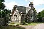
| |||
| Gordon Castle Gardens, Garden House | 57°37′05″N 3°05′34″W | Category B | 1627 | .jpg.webp)
| |||
| Speymouth Forest, Bridge Over The Burn Of Redpath | 57°35′20″N 3°02′09″W | Category C(S) | 1633 | Upload Photo | |||
| Fochabers, 4 Duke Street, St Margarets, Rear Walls And Stable | 57°36′54″N 3°05′48″W | Category B | 1552 | Upload Photo | |||
| Fochabers, 17 High Street And 7 East Street | 57°36′46″N 3°05′36″W | Category C(S) | 1561 | Upload Photo | |||
| Fochabers, 23 High Street | 57°36′47″N 3°05′39″W | Category C(S) | 1562 | Upload Photo | |||
| Fochabers, 58 High Street | 57°36′50″N 3°05′47″W | Category B | 1573 | Upload Photo | |||
| Fochabers, 2 The Square | 57°36′51″N 3°05′48″W | Category B | 1585 | Upload Photo | |||
| Gordon Castle, Fountain | 57°37′15″N 3°05′15″W | Category B | 1597 | Upload Photo | |||
| Fochabers, 24 High Street | 57°36′48″N 3°05′38″W | Category B | 1602 | Upload Photo | |||
| Tugnet, Salmon Fishing Station, Courtyard Square With Dwellings And Adjoining Fish House | 57°40′24″N 3°05′33″W | Category A | 1604 | Upload Photo | |||
| Tugnet, Tugnet House | 57°40′24″N 3°05′30″W | Category C(S) | 1607 | Upload Photo | |||
| Fochabers, 7 The Square | 57°36′50″N 3°05′51″W | Category B | 1615 | Upload Photo | |||
| Speymouth Forest, Meikle Dramlach Bridge Over Meikle Dramlach Burn | 57°35′54″N 3°03′02″W | Category B | 4836 | Upload Photo | |||
| The Square, The Fountain | 57°36′51″N 3°05′52″W | Category B | 1618 | 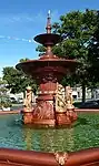
| |||
| Gordon Castle, West Lodge, Main Entrance With 2 Dwellings | 57°37′01″N 3°06′05″W | Category A | 1621 | 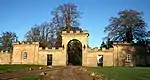
| |||
| Bellie Burial Ground, The Gordon Tomb | 57°38′03″N 3°05′05″W | Category A | 1539 | 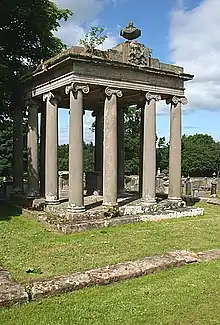
| |||
| Fochabers, 77 High Street | 57°36′52″N 3°05′55″W | Category B | 1545 | Upload Photo | |||
| Fochabers, Castle Street, Gordon Chapel (Episcopal Church) And Gordon Chapel House (Parsonage) | 57°36′55″N 3°05′47″W | Category A | 1549 | 
| |||
| Fochabers, 20 The Square With Garden Walls And Outbuildings | 57°36′53″N 3°05′52″W | Category C(S) | 1590 | Upload Photo | |||
| Fochabers, 22 The Square, Hadlow House | 57°36′53″N 3°05′53″W | Category C(S) | 1591 | Upload Photo | |||
| Fochabers, 26 Westmorland Street | 57°36′46″N 3°05′46″W | Category B | 1594 | Upload Photo | |||
| Fochabers, 18 High Street, The White Lodge (Former Free Church Manse) | 57°36′47″N 3°05′34″W | Category B | 1600 | Upload Photo | |||
| Fochabers, 36 High Street | 57°36′48″N 3°05′41″W | Category C(S) | 1603 | Upload Photo | |||
| Gordon Castle, Kennels | 57°37′08″N 3°04′56″W | Category B | 1625 | .jpg.webp)
| |||
| Gordon Castle, Old Fochabers Market Cross, Also Known As The Jougs And The Whipping Post | 57°37′06″N 3°05′36″W | Category C(S) | 1629 | 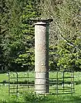
| |||
| Fochabers, 38 Maxwell Street | 57°36′53″N 3°05′47″W | Category C(S) | 1579 | Upload Photo | |||
| Fochabers, 18 The Square | 57°36′53″N 3°05′51″W | Category B | 1589 | Upload Photo | |||
| Gordon Castle Tower | 57°37′17″N 3°05′24″W | Category A | 1596 | 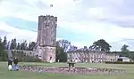
| |||
| Fochabers, High Street, Pringle Church (Former Free Church) | 57°36′48″N 3°05′37″W | Category C(S) | 1601 | Upload Photo | |||
| Tugnet, Willow Cottage | 57°40′22″N 3°05′14″W | Category B | 1608 | Upload Photo | |||
| Fochabers, 54 South Street | 57°36′49″N 3°05′56″W | Category B | 1611 | Upload Photo | |||
| Fochabers, 56 South Street | 57°36′49″N 3°05′57″W | Category B | 1612 | Upload Photo | |||
| Gordon Castle Farm, Steading With Dwellings | 57°37′04″N 3°04′59″W | Category A | 1623 | .jpg.webp)
| |||
| Roman Camp Cottage, (Formerly Roman Camp Gate Lodge) | 57°38′32″N 3°04′25″W | Category B | 1632 | Upload Photo | |||
| Swiss Cottage | 57°37′17″N 3°03′25″W | Category A | 1635 | .jpg.webp)
| |||
| Bellie Burial Ground | 57°38′03″N 3°05′06″W | Category B | 1538 | .jpg.webp)
| |||
| Fochabers, 83 High Street, Monair | 57°36′53″N 3°05′57″W | Category C(S) | 1548 | Upload Photo | |||
| Fochabers, 25 High Street | 57°36′47″N 3°05′40″W | Category C(S) | 1563 | Upload Photo | |||
| Focahbers, 70 High Street, Fulton House | 57°36′53″N 3°05′55″W | Category C(S) | 1574 | Upload Photo | |||
| Fochabers, 15 Maxwell Street | 57°36′49″N 3°05′39″W | Category B | 1576 | Upload Photo | |||
| Fochabers, 85 High Street | 57°36′53″N 3°05′58″W | Category C(S) | 1598 | Upload Photo | |||
| Fochabers, 48 South Street, Broomailly | 57°36′48″N 3°05′52″W | Category B | 1610 | Upload Photo |
Key
The scheme for classifying buildings in Scotland is:
- Category A: "buildings of national or international importance, either architectural or historic; or fine, little-altered examples of some particular period, style or building type."[1]
- Category B: "buildings of regional or more than local importance; or major examples of some particular period, style or building type, which may have been altered."[1]
- Category C: "buildings of local importance; lesser examples of any period, style, or building type, as originally constructed or moderately altered; and simple traditional buildings which group well with other listed buildings."[1]
In March 2016 there were 47,288 listed buildings in Scotland. Of these, 8% were Category A, and 50% were Category B, with the remaining 42% being Category C.[2]
See also
Notes
- Sometimes known as OSGB36, the grid reference (where provided) is based on the British national grid reference system used by the Ordnance Survey.
• "Guide to National Grid". Ordnance Survey. Retrieved 12 December 2007.
• "Get-a-map". Ordnance Survey. Retrieved 17 December 2007. - Historic Environment Scotland assign a unique alphanumeric identifier to each designated site in Scotland, for listed buildings this always begins with "LB", for example "LB12345".
References
- All entries, addresses and coordinates are based on data from Historic Scotland. This data falls under the Open Government Licence
- "What is Listing?". Historic Environment Scotland. Retrieved 29 May 2018.
- Scotland's Historic Environment Audit 2016 (PDF). Historic Environment Scotland and the Built Environment Forum Scotland. pp. 15–16. Retrieved 29 May 2018.
This article is issued from Wikipedia. The text is licensed under Creative Commons - Attribution - Sharealike. Additional terms may apply for the media files.