List of listed buildings in Boleskine and Abertarff
List
| Name | Location | Date Listed | Grid Ref. [note 1] | Geo-coordinates | Notes | LB Number [note 2] | Image |
|---|---|---|---|---|---|---|---|
| Foyers, Jane Fraser Memorial Obelisk | 57°15′11″N 4°30′16″W | Category B | 1852 |  Upload Photo | |||
| Caledonian Canal Cullochy Lock, Pair Lock Keepers' Houses (East Bank) | 57°05′57″N 4°44′21″W | Category C(S) | 1853 | Upload Photo | |||
| Culachy House, Cottage And Steading Range | 57°07′12″N 4°40′58″W | Category C(S) | 1858 | Upload Photo | |||
| Fort Augustus, Length Of High Rubble Wall To Rear Of Lovat Arms Hotel | 57°08′37″N 4°40′58″W | Category B | 1864 | Upload Photo | |||
| Fort Augustus, Nos 1-10 (Inclusive) Lovat Terrace | 57°08′37″N 4°41′05″W | Category B | 1868 | Upload Photo | |||
| Oich, Bridge Of, Over River Oich | 57°05′34″N 4°44′48″W | Category B | 1873 | Upload Photo | |||
| Foyers, Upper Foyers, Bridge Over River Foyers | 57°14′44″N 4°29′27″W | Category C(S) | 1882 | Upload Photo | |||
| Inverfarigaig (Old) Bridge Over River Farigaig | 57°16′53″N 4°27′14″W | Category B | 1870 | Upload Photo | |||
| Whitebridge, Old Bridge Over River Foyers | 57°12′15″N 4°30′10″W | Category A | 1874 | 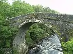
| |||
| Caledonian Canal, Abercalder Cottage (Swing Bridge Keeper's Cottage) | 57°05′34″N 4°44′35″W | Category C(S) | 1878 | Upload Photo | |||
| Garthbeg | 57°13′11″N 4°27′21″W | Category B | 1883 | Upload Photo | |||
| Glendoe, Bridge Over Allt An Reidhean | 57°08′37″N 4°38′19″W | Category B | 1884 | Upload Photo | |||
| Foyers Hydroelectric Power Scheme And Former Aluminium Smelter, Loch Mhor Dam | 57°13′48″N 4°27′55″W | Category C(S) | 51700 | Upload Photo | |||
| Boleskine Parish Church (Church Of Scotland) And Burial Ground | 57°13′50″N 4°28′26″W | Category B | 1846 | Upload Photo | |||
| Boleskine, Old Boleskine Church, Burial Ground And Watch House | 57°15′57″N 4°28′34″W | Category B | 1847 | Upload Photo | |||
| Culachy House | 57°07′16″N 4°40′58″W | Category B | 1857 | _(cropped).jpg.webp)
| |||
| Fort Augustus, Old Bridge Over River Oich | 57°08′48″N 4°40′41″W | Category B | 1865 | .jpg.webp)
| |||
| Fort Augustus, Road Bridge Carrying The A82 Over River Oich | 57°08′44″N 4°40′52″W | Category B | 1866 | Upload Photo | |||
| By Whitebridge, Knockie Lodge Hotel | 57°11′02″N 4°34′22″W | Category C(S) | 1876 | Upload Photo | |||
| Foyers Mains Steading | 57°15′02″N 4°30′00″W | Category C(S) | 1879 | Upload Photo | |||
| Fort Augustus, Former Railway Bridge Over Canal Side Road | 57°08′41″N 4°41′08″W | Category C(S) | 44608 | .jpg.webp)
| |||
| Ardachy Bridge Over River Tarff | 57°07′46″N 4°40′42″W | Category B | 1845 | Upload Photo | |||
| Boleskine Old Manse | 57°13′39″N 4°28′37″W | Category B | 1848 | Upload Photo | |||
| Boleskine House Stables | 57°15′57″N 4°28′25″W | Category B | 1850 | Upload Photo | |||
| Caledonian Canal, Cullochy Lock, Lock Keeper's Cottage (West Bank) | 57°05′56″N 4°44′24″W | Category C(S) | 1855 | Upload Photo | |||
| Glendoe, Bridge Carrying Re-Aligned A862 Over Allt Doe | 57°08′31″N 4°37′54″W | Category C(S) | 1869 | Upload Photo | |||
| Foyers Hydroelectric Power Scheme And Former Aluminium Smelter, River Tarff Intake | 57°14′44″N 4°29′20″W | Category C(S) | 51701 | Upload Photo | |||
| Culachy House, Bridge Carrying Drive To House Over Sunken Farm Track | 57°07′26″N 4°41′02″W | Category B | 1859 | .jpg.webp)
| |||
| Oich, Old Bridge Over River Oich | 57°05′36″N 4°44′43″W | Category A | 1872 | 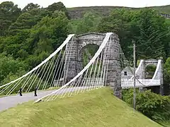
| |||
| Boleskine House Gate Lodge And Gate Piers With Gates | 57°16′00″N 4°28′27″W | Category B | 1877 | Upload Photo | |||
| Foyers, Lower Foyers Bridge Over River Foyers | 57°15′11″N 4°29′47″W | Category B | 1881 | Upload Photo | |||
| Glendoe, Old Bridge Over Allt Doe | 57°08′32″N 4°37′55″W | Category B | 1885 | Upload Photo | |||
| Fort Augustus Abbey, Gate Lodge | 57°08′37″N 4°40′44″W | Category B | 1863 | Upload Photo | |||
| Fort Augustus, Former Engine And Gunpowder House | 57°08′40″N 4°40′50″W | Category B | 1867 | Upload Photo | |||
| Whitebridge, New Bridge | 57°12′15″N 4°30′10″W | Category B | 1875 | Upload Photo | |||
| Foyers Hydroelectric Power Scheme, Former Aluminium Smelter, Powerhouse And Smelter | 57°15′19″N 4°29′35″W | Category A | 1880 | Upload Photo | |||
| Abercalder, Railway Cottage (L) And Mo Dhachaidh (R) | 57°05′50″N 4°43′51″W | Category C(S) | 1844 | Upload Photo | |||
| By Fort Augustus, Lochunagan | 57°07′47″N 4°41′28″W | Category B | 1851 | Upload Photo | |||
| Dell Lodge And Rear Service Cottages | 57°12′44″N 4°30′31″W | Category B | 1860 | Upload Photo | |||
| Fort Augustus Abbey Church | 57°08′41″N 4°40′36″W | Category A | 1862 | Upload Photo | |||
| Inverfarigaig Pier | 57°16′46″N 4°27′41″W | Category B | 1871 | Upload Photo | |||
| Boleskine House | 57°15′55″N 4°28′29″W | Category B | 1849 | Upload Photo | |||
| Caledonian Canal, Cullochy Lock, Storehouse (East Bank) | 57°05′54″N 4°44′21″W | Category B | 1854 | Upload Photo | |||
| Corrieyairack Pass, Bridge Over Allt Coire Uchdachan | 57°03′57″N 4°39′09″W | Category B | 1856 | Upload Photo | |||
| Fort Augustus Abbey, Monastery And School | 57°08′41″N 4°40′36″W | Category A | 1861 | 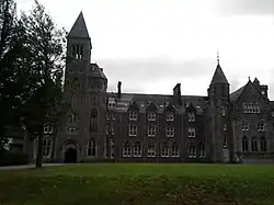 |
Key
The scheme for classifying buildings in Scotland is:
- Category A: "buildings of national or international importance, either architectural or historic; or fine, little-altered examples of some particular period, style or building type."[1]
- Category B: "buildings of regional or more than local importance; or major examples of some particular period, style or building type, which may have been altered."[1]
- Category C: "buildings of local importance; lesser examples of any period, style, or building type, as originally constructed or moderately altered; and simple traditional buildings which group well with other listed buildings."[1]
In March 2016 there were 47,288 listed buildings in Scotland. Of these, 8% were Category A, and 50% were Category B, with the remaining 42% being Category C.[2]
See also
Notes
- Sometimes known as OSGB36, the grid reference (where provided) is based on the British national grid reference system used by the Ordnance Survey.
• "Guide to National Grid". Ordnance Survey. Retrieved 12 December 2007.
• "Get-a-map". Ordnance Survey. Retrieved 17 December 2007. - Historic Environment Scotland assign a unique alphanumeric identifier to each designated site in Scotland, for listed buildings this always begins with "LB", for example "LB12345".
References
- All entries, addresses and coordinates are based on data from Historic Scotland. This data falls under the Open Government Licence
- "What is Listing?". Historic Environment Scotland. Retrieved 29 May 2018.
- Scotland's Historic Environment Audit 2016 (PDF). Historic Environment Scotland and the Built Environment Forum Scotland. pp. 15–16. Retrieved 29 May 2018.
This article is issued from Wikipedia. The text is licensed under Creative Commons - Attribution - Sharealike. Additional terms may apply for the media files.