List of listed buildings in Campbeltown
List
| Name | Location | Date Listed | Grid Ref. [note 1] | Geo-coordinates | Notes | LB Number [note 2] | Image |
|---|---|---|---|---|---|---|---|
| 48 Shore Street, With Boundary Wall | 55°25′23″N 5°36′09″W | Category C(S) | 43134 |  Upload Photo | |||
| Witchburn Road And Dell Road, Municipal Offices, Including Boundary Walls And Garden | 55°25′26″N 5°36′36″W | Category C(S) | 43140 | Upload Photo | |||
| Castlehill, Royal Bank Of Scotland, With Walls, Railings And Gates | 55°25′23″N 5°36′24″W | Category C(S) | 43056 | Upload Photo | |||
| 2 Castlehill And Lorne Street, With Railing, Boundary Wall, And Outbuilding | 55°25′24″N 5°36′24″W | Category C(S) | 43059 | Upload Photo | |||
| 1-7 (Odd Nos) Glebe Street And Big Kiln Street | 55°25′25″N 5°36′28″W | Category C(S) | 43069 | Upload Photo | |||
| 10-12 (Even Nos) Glebe Street, With Boundary Walls, Railing, And Outbuilding | 55°25′28″N 5°36′30″W | Category B | 43070 | 
| |||
| Hall Street, Between New Quay And Old Quay, Harbour Wall | 55°25′26″N 5°36′09″W | Category C(S) | 43073 | Upload Photo | |||
| 19-33 (Odd Nos) John Street, 1-21 (Odd Nos) Princes Street, 18 And 20 (Even Nos) Princes Street, 3 Queen Street And 20-30 (Even Nos) High Street Dalintober, With Boundary Walls And Gatepiers | 55°25′43″N 5°36′16″W | Category B | 43081 | 
| |||
| 68 Kirk Street | 55°25′21″N 5°36′09″W | Category B | 43097 | Upload Photo | |||
| 9 Longrow, And Burnside Street, Galbraith & Cochrane | 55°25′29″N 5°36′23″W | Category B | 43102 | Upload Photo | |||
| 69-73 (Odd Nos) Longrow, Including Boundary Walls | 55°25′33″N 5°36′28″W | Category B | 43108 | 
| |||
| Low Askomil, Belmount, With Service Wing, Boundary Walls, Retaining Wall, And Gatepiers | 55°25′41″N 5°35′28″W | Category C(S) | 43110 | Upload Photo | |||
| Low Askomil, Hawthorne, Including Boundary Walls And Gates | 55°25′41″N 5°35′30″W | Category B | 43112 | Upload Photo | |||
| 40-48 (Even Nos) Main Street And 1-21 (Odd Nos) Longrow South | 55°25′27″N 5°36′20″W | Category B | 43124 | 
| |||
| 6-34 (Even Nos) Argyll Street, Barochan Place, Including Wall, Wash-Houses, And Railings | 55°25′22″N 5°36′20″W | Category B | 43051 | Upload Photo | |||
| Low Askomil, Rosemount, With Gardener's Cottage, Conservatory, Coach-House, And Boundary Walls | 55°25′41″N 5°35′34″W | Category B | 22938 | Upload Photo | |||
| New Quay Street, Highland Kirk (Church Of Scotland), With Boundary Walls And Gate Piers | 55°25′17″N 5°36′15″W | Category B | 22942 | Upload Photo | |||
| Kirk Street And St John Street, Highland Church Hall (Formerly Lowland Church) | 55°25′24″N 5°36′13″W | Category B | 22944 | Upload Photo | |||
| Kirk Street, The Manse, With Garage, Gatepiers, And Boundary Walls | 55°25′23″N 5°36′10″W | Category B | 22945 | Upload Photo | |||
| 54-56 (Even Nos) Kirk Street, With Gatepiers And Gate | 55°25′22″N 5°36′11″W | Category C(S) | 22947 | Upload Photo | |||
| New Quay Street And Kilkerran Road, Pensioners Row | 55°25′22″N 5°36′05″W | Category C(S) | 22952 | Upload Photo | |||
| Kilkerran Road, Courthill, With Coach House, Boundary Walls, Gates, And Gatepiers | 55°25′18″N 5°36′03″W | Category B | 22955 | Upload Photo | |||
| Kilkerran Road, North Park And Tudor Court, With Garage, Outbuildings, Boundary Walls, Gates And Gatepiers | 55°25′11″N 5°35′54″W | Category B | 22958 | Upload Photo | |||
| St John Street And Hall Street, Public Library And Museum, With Librarian's House, Garden, Railings, Gates, And Gatepiers | 55°25′26″N 5°36′11″W | Category A | 22964 | 
| |||
| 2-14 (Even Nos) Main Street, Maclean Place, With Outbuilding | 55°25′29″N 5°36′17″W | Category B | 22914 | Upload Photo | |||
| 50-52 (Even Nos) Main Street And Cross Street | 55°25′27″N 5°36′21″W | Category B | 22917 | Upload Photo | |||
| Lossit Home Farm | 55°25′11″N 5°44′23″W | Category C(S) | 4918 | Upload Photo | |||
| Lodge And Gate Kilellan Policies | 55°22′26″N 5°39′33″W | Category C(S) | 4919 | Upload Photo | |||
| Davaar Lighthouse | 55°25′41″N 5°32′26″W | Category B | 4920 | .jpg.webp)
| |||
| Cross Street, Feathers Inn | 55°25′27″N 5°36′23″W | Category B | 43061 | Upload Photo | |||
| 15 To 53 Dalaruan Street, Dalaruan Terrace, With Boundary Walls And Gates | 55°25′52″N 5°36′35″W | Category B | 43063 | Upload Photo | |||
| Gallowhill Road, Gallowhill Farm, Including Boundary Walls And Gatepiers | 55°25′28″N 5°36′43″W | Category B | 43066 | Upload Photo | |||
| Hall Street And Old Quay Head, Christian Institute | 55°25′28″N 5°36′14″W | Category C(S) | 43072 | Upload Photo | |||
| High Askomil, Dunara, With Outhouses, Retaining Wall, Boundary Walls, Gates, And Gatepiers | 55°25′44″N 5°35′31″W | Category C(S) | 43077 | Upload Photo | |||
| Kilkerran Road, Knockbay, With Boundary Walls, Gates And Gatepiers | 55°25′03″N 5°35′34″W | Category C(S) | 43085 | Upload Photo | |||
| Kilkerran Road, Rockwood, With Outbuilding, Boundary Walls, Gates And Gatepiers | 55°25′07″N 5°35′44″W | Category B | 43089 | Upload Photo | |||
| 1-3 (Odd Nos) Longrow, New Quay Chandlers | 55°25′28″N 5°36′23″W | Category C(S) | 43100 | Upload Photo | |||
| 23 To 29 Longrow, Including Outbuildings | 55°25′30″N 5°36′25″W | Category B | 43105 | Upload Photo | |||
| Low Askomil, Craigard, With Boundary Walls And Railings | 55°25′42″N 5°35′16″W | Category B | 43111 | Upload Photo | |||
| North Shore Street, Sandbank | 55°25′43″N 5°36′02″W | Category C(S) | 43127 | Upload Photo | |||
| Saddell Street, Former Benmore Distillery (West Coast Motors), Including Warehouse, Kiln, Offices, Cooperage, And Boundary Wall | 55°25′46″N 5°36′25″W | Category B | 43129 | 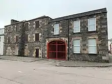
| |||
| Kinloch Public Park, To South Of Swimming Baths, Statue Of William Mackinnon | 55°56′28″N 4°35′02″W | Category B | 24899 | 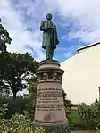
| |||
| Low Askomil, Rockbank, Including Boundary Walls, Gatepiers, Retaining Walls And Outbuildings | 55°25′41″N 5°35′37″W | Category B | 22937 | Upload Photo | |||
| Low Askomil, Seaside, With Boundary Wall, Gatepiers, And Outbuilding | 55°25′36″N 5°34′58″W | Category C(S) | 22939 | Upload Photo | |||
| Argyll Street And New Quay Street, Kirklea, (Caber Feidh) Including Boundary Walls | 55°25′19″N 5°36′13″W | Category B | 22943 | Upload Photo | |||
| 58-60 (Even Nos) Kirk Street, With Walls And Outhouse | 55°25′22″N 5°36′11″W | Category B | 22948 | Upload Photo | |||
| Hall Street, the Wee Picture House | 55°25′26″N 5°36′12″W | Category A | 22965 | 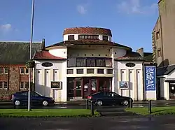
| |||
| Main Street, Old Post Office | 55°25′25″N 5°36′21″W | Category C(S) | 22912 | Upload Photo | |||
| 5 Bolgam Street, Former Gaol And Courthouse | 55°25′28″N 5°36′19″W | Category B | 22915 | Upload Photo | |||
| Castlehill, Drumfin And Former Lowland Church Manse, With Walls, Railings, And Gatepiers | 55°25′23″N 5°36′25″W | Category B | 22920 | Upload Photo | |||
| High Street Dalintober, Springfield House, With Stables And Gatepiers | 55°25′45″N 5°35′59″W | Category B | 22933 | Upload Photo | |||
| Low Askomil, Lilybank, With Retaining Walls, And Gatepiers | 55°25′41″N 5°35′39″W | Category C(S) | 22936 | Upload Photo | |||
| Dell Road, Stanley Place, Including Railings | 55°25′28″N 5°36′37″W | Category B | 43064 | Upload Photo | |||
| Esplanade, War Memorial | 55°25′38″N 5°36′16″W | Category C(S) | 43065 | Upload Photo | |||
| Kilkerran Road, Former Lifeboat House, With Boundary Wall And Gatepiers | 55°25′05″N 5°35′39″W | Category B | 43086 | 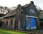
| |||
| 15-17 (Odd Nos) Longrow, Hardware Stores | 55°25′29″N 5°36′24″W | Category C(S) | 43103 | Upload Photo | |||
| Main Street, Argyll Arms Hotel | 55°25′26″N 5°36′22″W | Category B | 43121 | 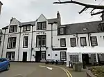
| |||
| North Shore Street, Dalintober Quay | 55°25′41″N 5°36′02″W | Category B | 43126 | Upload Photo | |||
| Argyll Street, St Kiaran's Episcopal Church, Including Boundary Wall, Gates And Gatepiers | 55°25′24″N 5°36′19″W | Category C(S) | 43048 | Upload Photo | |||
| 64 And 66 Kirk Street, With Outbuilding | 55°25′21″N 5°36′09″W | Category B | 22949 | Upload Photo | |||
| Kilkerran Road, Stronvaar, With Outbuildings, Railings, Boundary Walls And Gatepiers | 55°25′16″N 5°36′02″W | Category B | 22956 | Upload Photo | |||
| Kilkerran Road, East Cliff, With Garage, Boundary Wall, Gates And Gatepiers | 55°25′07″N 5°35′46″W | Category B | 22960 | Upload Photo | |||
| Kilkerran Road, Kilkerran Cottage With Gatepiers, Outbuildings, And Castle Remains | 55°25′00″N 5°35′22″W | Category C(S) | 22961 | Upload Photo | |||
| 58-62 (Even Nos) Main Street | 55°25′25″N 5°36′22″W | Category B | 22919 | Upload Photo | |||
| Former Lowland Church Manse, Off Castlehill | 55°25′23″N 5°36′30″W | Category C(S) | 22921 | Upload Photo | |||
| 6-10 (Even Nos) Union Street | 55°25′27″N 5°36′22″W | Category B | 22922 | Upload Photo | |||
| St John Street, St Kieran's Chapel House, (Roman Catholic), Including Boundary Wall, Gates, And Gatepiers | 55°25′23″N 5°36′15″W | Category C(S) | 43131 | Upload Photo | |||
| 18-24 (Even Nos) Shore Street, With Boundary Wall | 55°25′26″N 5°36′14″W | Category B | 43133 | Upload Photo | |||
| Square Between Union Street And Burnside, Warehouse | 55°25′28″N 5°36′23″W | Category B | 43135 | Upload Photo | |||
| 34-36 (Even Nos) Union Street | 55°25′29″N 5°36′21″W | Category C(S) | 43138 | Upload Photo | |||
| Witchburn Road, Former Cottage Hospital, With Steps, Retaining Wall, And Boundary Walls | 55°25′23″N 5°36′48″W | Category C(S) | 43139 | Upload Photo | |||
| Castlehill And Argyll Street, White Hart Hotel | 55°25′24″N 5°36′23″W | Category B | 43058 | 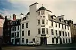
| |||
| Glebe Street And Well Close, Springbank Distillery | 55°25′32″N 5°36′33″W | Category B | 43067 | 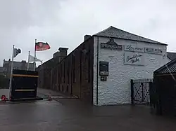
| |||
| Hall Street, Royal Avenue Mansions | 55°25′27″N 5°36′14″W | Category B | 43074 | Upload Photo | |||
| 47-49 (Odd Nos) Longrow | 55°25′32″N 5°36′27″W | Category C(S) | 43107 | Upload Photo | |||
| 83-103 (Odd Nos) Millknowe Road With Boundary Wall, Retaining Wall, And Steps | 55°25′49″N 5°36′43″W | Category C(S) | 43125 | Upload Photo | |||
| Ralston Road, Police Station, With Boundary Walls And Gatepiers | 55°25′21″N 5°36′25″W | Category C(S) | 43128 | Upload Photo | |||
| Argyll Street And New Quay Street, Muneroy, Annfield And Benroy, With Boundary Walls And Gates | 55°25′20″N 5°36′11″W | Category C(S) | 43047 | Upload Photo | |||
| Big Kiln Street, Former Free Church School | 55°25′24″N 5°36′26″W | Category B | 43053 | 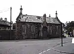
| |||
| Kirk Street, New Quay Street And Shore Street, Craigdhu Mansions, With Wash-House, Boundary Wall, And Gates | 55°25′21″N 5°36′08″W | Category B | 22950 | Upload Photo | |||
| Lochend Street, Warehouse | 55°25′40″N 5°36′30″W | Category B | 22966 | 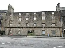
| |||
| Castlehill, Fleming's Land, With Wash-Houses, Garden Walls, And Gates | 55°25′23″N 5°36′23″W | Category B | 22911 | Upload Photo | |||
| Main Street, Town Hall, Including Lamp Standards | 55°25′26″N 5°36′21″W | Category B | 22918 | 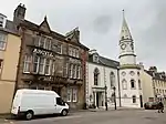
| |||
| 38-48 (Even Nos) Longrow | 55°25′32″N 5°36′25″W | Category B | 22926 | Upload Photo | |||
| Millknowe Road, Former Hazelburn Distillery, Including Tenement, Managers Offices, Warehouses, Gatepier, And Boundary Wall | 55°25′42″N 5°36′35″W | Category B | 22929 | Upload Photo | |||
| Low Askomil, Springbank House, With Retaining And Boundary Walls, Gatepiers And Summerhouse | 55°25′42″N 5°35′45″W | Category B | 22934 | Upload Photo | |||
| Kilkivan Chapel (St. Kevin's) Kilkivan Burial Ground | 55°25′07″N 5°42′44″W | Category B | 4916 | Upload Photo | |||
| Lussa Hyrdo Electric Scheme, Lussa Power Station, Including Boundary Walls | 55°28′34″N 5°35′05″W | Category B | 51689 | Upload Photo | |||
| St John Street And Stewart Road, St Kieran's Primary School, With Boundary Wall, Railings, Playshelters, Gates, And Gatepiers | 55°25′21″N 5°36′21″W | Category C(S) | 43132 | Upload Photo | |||
| Big Kiln Street, Heritage Centre, (Formerly Lorne Street Free Gaelic Church) With Hall, Boundary Walls, Railings, Gates, And Gatepiers | 55°25′24″N 5°36′29″W | Category C(S) | 43054 | 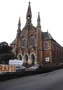
| |||
| Glengyle Road, Former Glengyle Distillery, Including Warehouses And Office Building | 55°25′38″N 5°36′41″W | Category B | 43071 | Upload Photo | |||
| High Askomil, Airdaluinn With Railings, Gatepiers, Retaining And Boundary Walls | 55°25′45″N 5°35′45″W | Category B | 43075 | Upload Photo | |||
| High Street Dalintober, Braefoot House, With Railings, Gate, Boundary Walls, And Outhouses | 55°25′45″N 5°36′04″W | Category C(S) | 43078 | Upload Photo | |||
| Kilkerran Road, Markland, With Gate, Retaining Wall And Boundary Walls | 55°25′13″N 5°35′58″W | Category C(S) | 43087 | Upload Photo | |||
| Low Askomil, Beach Hill, With Outbuildings, Garage, Boundary Walls, And Gatepiers | 55°25′42″N 5°35′24″W | Category B | 43109 | Upload Photo | |||
| Low Askomil, 1-3 (Inclusive Nos) St Clair Terrace, With Boundary Walls And Gates | 55°25′43″N 5°35′54″W | Category B | 43120 | Upload Photo | |||
| 31 Argyll Street, Barochan House, With Boundary Wall And Railings | 55°25′21″N 5°36′14″W | Category B | 43050 | Upload Photo | |||
| High Askomil, Bellgrove, With Stable, Laundry, Outbuildings, Boundary Walls, Gates, And Gatepiers | 55°25′45″N 5°35′23″W | Category A | 22940 | Upload Photo | |||
| 52 Kirk Street, Cnocbaan, With Boundary Wall And Gate | 55°25′23″N 5°36′12″W | Category B | 22946 | Upload Photo | |||
| Kilkerran Road, 'Ailsa', With Railing And Garden Wall | 55°25′20″N 5°36′03″W | Category B | 22954 | Upload Photo | |||
| Kilkerran Road, South Park, With Outbuildings, Boundary Walls, Gates, And Gatepiers | 55°25′08″N 5°35′50″W | Category B | 22959 | Upload Photo | |||
| Kilkerran Road, Kilkerran Churchyard And Cemetery, Including Calen Maceachern's Cross And Cristin's Cross, Boundary Walls, Entrance Gates And Gatepiers | 55°24′55″N 5°35′29″W | Category B | 22962 | Upload Photo | |||
| Whinhill House, Including Outbuildings, Gates, And Gatepiers | 55°25′35″N 5°37′19″W | Category C(S) | 22963 | Upload Photo | |||
| Old Quay Head, Campbeltown Cross | 55°25′29″N 5°36′14″W | Category A | 22913 | 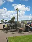
| |||
| Kilchrist Castle | 55°24′04″N 5°38′49″W | Category B | 4921 | Upload Photo | |||
| 11-13 (Odd Nos) Union Street | 55°25′28″N 5°36′23″W | Category C(S) | 43136 | Upload Photo | |||
| High Street Dalintober, Glen Scotia Distillery (Formerly Scotia Distillery) With Warehouses | 55°25′46″N 5°36′16″W | Category B | 43079 | 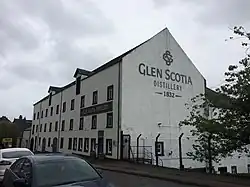
| |||
| 7-11 (Odd Nos) Kirk Street | 55°25′26″N 5°36′18″W | Category B | 43091 | Upload Photo | |||
| 65 Kirk Street | 55°25′26″N 5°36′17″W | Category C(S) | 43095 | Upload Photo | |||
| 70 Kirk Street And New Quay Street, Ivybank, With Boundary Wall | 55°25′21″N 5°36′09″W | Category B | 43099 | Upload Photo | |||
| 5-7 (Odd Nos) Longrow, Streetwise | 55°25′29″N 5°36′23″W | Category B | 43101 | Upload Photo | |||
| 41-45 (Odd Nos) Longrow, Including Boundary Wall | 55°25′31″N 5°36′26″W | Category B | 43106 | Upload Photo | |||
| Main Street, The Club | 55°25′25″N 5°36′23″W | Category B | 43122 | Upload Photo | |||
| St John Street, St Kieran's Chapel, (Roman Catholic), Including Boundary Wall, Gates, And Gatepiers | 55°25′23″N 5°36′16″W | Category C(S) | 43130 | Upload Photo | |||
| 27-29 (Odd Nos) Argyll Street, With Gate And Gatepiers | 55°25′21″N 5°36′15″W | Category B | 43049 | Upload Photo | |||
| Balegreggan House And The Stables, Including Boundary Wall | 55°26′05″N 5°36′07″W | Category C(S) | 43052 | Upload Photo | |||
| 2-4 Kilkerran Road And New Quay Street, Including Boundary Wall And Gate | 55°25′20″N 5°36′08″W | Category C(S) | 22951 | Upload Photo | |||
| 16-20 ( Even Nos) Main Street And 1-3 (Odd Nos) Bolgam Street | 55°25′28″N 5°36′19″W | Category B | 22916 | Upload Photo | |||
| 12-18 (Even Nos) Burnside Street | 55°25′28″N 5°36′26″W | Category B | 22923 | Upload Photo | |||
| 11-13 (Odd Nos) Longrow And Burnside Street, Corner Shop | 55°25′29″N 5°36′24″W | Category B | 22924 | Upload Photo | |||
| 61-67 (Odd Nos) Longrow, Including Boundary Wall | 55°25′33″N 5°36′28″W | Category B | 22927 | Upload Photo | |||
| 81 Millknowe Road, With Boundary Wall | 55°25′48″N 5°36′43″W | Category C(S) | 22930 | Upload Photo | |||
| Kilchousland Chapel (St. Constantine's) Chapel Kilchousland Burial Ground | 55°26′26″N 5°33′22″W | Category B | 4915 | Upload Photo | |||
| Oatfield House | 55°24′05″N 5°39′51″W | Category B | 4922 | Upload Photo | |||
| 30-32 (Even Nos) Union Street | 55°25′29″N 5°36′21″W | Category B | 43137 | 
| |||
| Castlehill, Sheriff Court House, With Boundary Wall | 55°25′22″N 5°36′26″W | Category B | 43057 | 
| |||
| Cross Street, Wee Toon Lounge Bar | 55°25′26″N 5°36′22″W | Category C(S) | 43062 | Upload Photo | |||
| 13-15 (Odd Nos) Kirk Street | 55°25′26″N 5°36′18″W | Category C(S) | 43092 | Upload Photo | |||
| 49 Kirk Street And St John Street, With Boundary Wall | 55°25′24″N 5°36′12″W | Category C(S) | 43094 | Upload Photo | |||
| 32 Kirk Street | 55°25′25″N 5°36′16″W | Category B | 43096 | Upload Photo | |||
| 19-21 (Odd Nos) Longrow, Clydesdale Bank, With Railings And Gatepiers | 55°25′30″N 5°36′24″W | Category B | 43104 | Upload Photo | |||
| Main Street, Royal Hotel | 55°25′30″N 5°36′15″W | Category C(S) | 43123 | 
| |||
| Longrow, Lorne And Lowland Church (Church Of Scotland), With Hall, Boundary Walls, Gates And Gatepiers | 55°25′29″N 5°36′30″W | Category B | 22925 | Upload Photo | |||
| Tarbert Road, Drumore House, Including Boundary Walls And Gatepiers | 55°25′56″N 5°36′42″W | Category C(S) | 22931 | Upload Photo | |||
| High Street Dalintober, The Hall, With Boundary Walls And Gatepiers | 55°25′45″N 5°36′02″W | Category C(S) | 22932 | 
| |||
| Lossit House | 55°25′09″N 5°44′27″W | Category B | 4917 | Upload Photo | |||
| Witchburn Road, Entrance Arch To Former Poorhouse (Witchburn House) | 55°25′23″N 5°36′42″W | Category C(S) | 43141 | Upload Photo | |||
| Burnside Street, Burnside Bar | 55°25′28″N 5°36′24″W | Category C(S) | 43055 | Upload Photo | |||
| Cross Street And Burnside Street, Commercial Inn | 55°25′27″N 5°36′24″W | Category B | 43060 | 
| |||
| Glebe Street, Former Springside Distillery, Duty Free Warehouse No 1 | 55°25′27″N 5°36′29″W | Category B | 43068 | Upload Photo | |||
| High Askomil, Auchinlee, With Boundary Walls, Gate, And Gatepiers | 55°25′45″N 5°35′27″W | Category B | 43076 | Upload Photo | |||
| High Street Dalintober, Springfield Terrace, Including Boundary Walls And Gatepiers | 55°25′44″N 5°36′02″W | Category C(S) | 43080 | Upload Photo | |||
| Kilkerran Road, Redholme, With Outbuilding, Boundary Walls, Gates And Gatepiers | 55°25′10″N 5°35′52″W | Category A | 43088 | Upload Photo | |||
| Kinloch Road And Lochend Street, Former Mission Hall, Including Boundary Wall, Railings, And Gates | 55°25′38″N 5°36′28″W | Category B | 43090 | Upload Photo | |||
| 17-19 (Odd Nos) Kirk Street | 55°25′26″N 5°36′17″W | Category C(S) | 43093 | Upload Photo | |||
| Low Askomil, Seabank, Including Boundary Walls And Gatepiers | 55°25′43″N 5°35′49″W | Category B | 43119 | Upload Photo | |||
| Argyll Street, Episcopal Church Rectory, With Boundary Wall, Gates And Gatepiers | 55°25′23″N 5°36′18″W | Category B | 43046 | Upload Photo | |||
| High Askomil, Rothmar, With Garage, Terrace, Boundary And Retaining Walls, Gates And Gatepiers | 55°25′44″N 5°35′35″W | Category A | 22941 | Upload Photo | |||
| Hutcheon Road, Limecraigs House, Including, Pavilions, Steading, Stables Cottage, Boundary Walls, And Gatepiers | 55°25′06″N 5°36′02″W | Category C(S) | 22957 | Upload Photo | |||
| Castlehill, Castlehill Mansions, (Formerly Lowland Church Of Scotland) With Boundary Walls, Railings, And Gatepiers | 55°25′21″N 5°36′27″W | Category B | 22910 | Upload Photo | |||
| Low Askomil, Fairview, With Boundary Walls And Gatepiers | 55°25′41″N 5°35′40″W | Category B | 22935 | Upload Photo |
Key
The scheme for classifying buildings in Scotland is:
- Category A: "buildings of national or international importance, either architectural or historic; or fine, little-altered examples of some particular period, style or building type."[1]
- Category B: "buildings of regional or more than local importance; or major examples of some particular period, style or building type, which may have been altered."[1]
- Category C: "buildings of local importance; lesser examples of any period, style, or building type, as originally constructed or moderately altered; and simple traditional buildings which group well with other listed buildings."[1]
In March 2016 there were 47,288 listed buildings in Scotland. Of these, 8% were Category A, and 50% were Category B, with the remaining 42% being Category C.[2]
Notes
- Sometimes known as OSGB36, the grid reference (where provided) is based on the British national grid reference system used by the Ordnance Survey.
• "Guide to National Grid". Ordnance Survey. Retrieved 12 December 2007.
• "Get-a-map". Ordnance Survey. Retrieved 17 December 2007. - Historic Environment Scotland assign a unique alphanumeric identifier to each designated site in Scotland, for listed buildings this always begins with "LB", for example "LB12345".
References
- All entries, addresses and coordinates are based on data from Historic Scotland. This data falls under the Open Government Licence
- "What is Listing?". Historic Environment Scotland. Retrieved 29 May 2018.
- Scotland's Historic Environment Audit 2016 (PDF). Historic Environment Scotland and the Built Environment Forum Scotland. pp. 15–16. Retrieved 29 May 2018.
This article is issued from Wikipedia. The text is licensed under Creative Commons - Attribution - Sharealike. Additional terms may apply for the media files.