List of listed buildings in Chapel of Garioch, Aberdeenshire
List
| Name | Location | Date Listed | Grid Ref. [note 1] | Geo-coordinates | Notes | LB Number [note 2] | Image |
|---|---|---|---|---|---|---|---|
| Pittodrie House Gunroom | 57°18′20″N 2°30′14″W | Category B | 2854 |  Upload Photo | |||
| Logie House, Doocot | 57°19′30″N 2°29′49″W | Category B | 2860 | 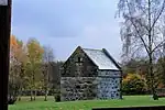
| |||
| Logie Durno Church And Churchyard | 57°19′38″N 2°29′34″W | Category C(S) | 2825 | Upload Photo | |||
| Pitcaple Castle | 57°19′28″N 2°27′16″W | Category A | 2830 | Upload Photo | |||
| St. John's R.C. Church And Presbytery House Fetternear | 57°14′58″N 2°27′59″W | Category B | 2834 | 
| |||
| Fetternear, Stable Offices | 57°14′47″N 2°27′28″W | Category C(S) | 2836 | Upload Photo | |||
| Chapel Of Garioch Parish Church | 57°18′26″N 2°28′21″W | Category B | 2845 | 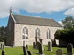
| |||
| Logie Country House (Logie House Hotel) | 57°19′20″N 2°29′29″W | Category B | 2857 | 
| |||
| East Balhalgardy Cottar Houses Occupied By Dorward And Green (Old Farmhouse) | 57°18′15″N 2°23′53″W | Category B | 2832 | Upload Photo | |||
| Ruins Of Old House Of Fetternear | 57°14′37″N 2°27′36″W | Category B | 2835 | _(geograph_6516966).jpg.webp)
| |||
| Chapel Of Garioch, Churchyard | 57°18′26″N 2°28′21″W | Category C(S) | 2847 | Upload Photo | |||
| Outbuildings (Former Steading) Of Lynwood (Formerly Skelpers Farm) | 57°18′27″N 2°28′25″W | Category C(S) | 2848 | Upload Photo | |||
| Pittodrie House | 57°18′19″N 2°30′13″W | Category B | 2853 | 
| |||
| Former Roadbridge Over Lochter Burn | 57°18′15″N 2°23′19″W | Category C(S) | 6708 | 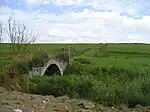
| |||
| Pitcaple, Pitbee | 57°18′58″N 2°28′04″W | Category C(S) | 6410 | Upload Photo | |||
| Harlaw Monument | 57°18′24″N 2°24′51″W | Category B | 2831 | .jpg.webp)
| |||
| Logie Durno Churchyard, Dalrymple Horn Elphinstone Burial Enclosure | 57°19′38″N 2°29′35″W | Category B | 2826 | Upload Photo | |||
| Mill Of Durno, Grain Mill | 57°19′15″N 2°28′22″W | Category B | 2827 | Upload Photo | |||
| Chapel Of Garioch, Churchyard Gateway. (Pittodrie's Yate) | 57°18′25″N 2°28′23″W | Category A | 2846 | %252C_Chapel_of_Garioch_(geograph_4647329).jpg.webp)
| |||
| Inverarmsay Bridge Over River Urie | 57°18′42″N 2°25′52″W | Category B | 2850 | .jpg.webp)
| |||
| Pittodrie House Sundial | 57°18′17″N 2°30′10″W | Category B | 2855 | Upload Photo | |||
| Bridge Of Pitcaple Over River Urie | 57°19′25″N 2°27′50″W | Category C(S) | 2829 | Upload Photo | |||
| Harlaw House | 57°18′46″N 2°25′17″W | Category C(S) | 2851 | 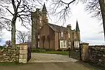
| |||
| Arcot, (Former Free Manse) Pitcaple | 57°19′01″N 2°27′44″W | Category B | 2828 | Upload Photo | |||
| Logie House, Walled Garden | 57°19′23″N 2°29′46″W | Category B | 2859 | Upload Photo | |||
| Blairdaff Church | 57°15′02″N 2°30′17″W | Category B | 2833 | 
| |||
| Logie House Lodge | 57°19′14″N 2°30′00″W | Category C(S) | 2856 | Upload Photo |
Key
The scheme for classifying buildings in Scotland is:
- Category A: "buildings of national or international importance, either architectural or historic; or fine, little-altered examples of some particular period, style or building type."[1]
- Category B: "buildings of regional or more than local importance; or major examples of some particular period, style or building type, which may have been altered."[1]
- Category C: "buildings of local importance; lesser examples of any period, style, or building type, as originally constructed or moderately altered; and simple traditional buildings which group well with other listed buildings."[1]
In March 2016 there were 47,288 listed buildings in Scotland. Of these, 8% were Category A, and 50% were Category B, with the remaining 42% being Category C.[2]
Notes
- Sometimes known as OSGB36, the grid reference (where provided) is based on the British national grid reference system used by the Ordnance Survey.
• "Guide to National Grid". Ordnance Survey. Retrieved 12 December 2007.
• "Get-a-map". Ordnance Survey. Retrieved 17 December 2007. - Historic Environment Scotland assign a unique alphanumeric identifier to each designated site in Scotland, for listed buildings this always begins with "LB", for example "LB12345".
References
- All entries, addresses and coordinates are based on data from Historic Scotland. This data falls under the Open Government Licence
- "What is Listing?". Historic Environment Scotland. Retrieved 29 May 2018.
- Scotland's Historic Environment Audit 2016 (PDF). Historic Environment Scotland and the Built Environment Forum Scotland. pp. 15–16. Retrieved 29 May 2018.
This article is issued from Wikipedia. The text is licensed under Creative Commons - Attribution - Sharealike. Additional terms may apply for the media files.