List of listed buildings in Cockpen, Midlothian
List
| Name | Location | Date Listed | Grid Ref. [note 1] | Geo-coordinates | Notes | LB Number [note 2] | Image |
|---|---|---|---|---|---|---|---|
| Dalhousie Grange, Including Gatepiers | 55°51′50″N 3°05′27″W | Category C(S) | 783 |  Upload Photo | |||
| Dalhousie Castle, Bridge Over River South Esk To Se Of Castle | 55°51′37″N 3°04′55″W | Category C(S) | 785 | 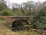
| |||
| Dalhousie West Lodge, Including Railings | 55°51′45″N 3°05′29″W | Category C(S) | 46130 | Upload Photo | |||
| Millbank House, Including Ancillary Structures, Walled Garden, Gates, Gatepiers And Boundary Walls | 55°50′39″N 3°03′40″W | Category C(S) | 46136 | Upload Photo | |||
| Redheugh Farmhouse And Steading, Including Ancillary Structures And Boundary Walls | 55°51′08″N 3°04′08″W | Category C(S) | 46139 | Upload Photo | |||
| Upper Dalhousie Farmhouse And Farm, Including Ancillary Structure, Implement Shed, Gates, Gatepiers And Walled Garden | 55°51′26″N 3°05′58″W | Category C(S) | 46141 | Upload Photo | |||
| Cockpen Farm | 55°51′44″N 3°04′38″W | Category C(S) | 49645 | Upload Photo | |||
| Cockpen Old Parish Church And Burial Ground | 55°51′31″N 3°04′38″W | Category B | 787 | Upload Photo | |||
| Kirkhill Hotel, Formerly Kirkhill House, Including Railings | 55°50′53″N 3°04′26″W | Category B | 788 | Upload Photo | |||
| Gowkshill Farmhouse And Steading, Including Chimney Stalk | 55°51′21″N 3°03′23″W | Category C(S) | 46133 | Upload Photo | |||
| Grove Farm, Former Dalhousie Walled Garden | 55°52′00″N 3°04′42″W | Category C(S) | 46134 | Upload Photo | |||
| The Glebe House (Former Cockpen Manse), Including Stable Block | 55°51′56″N 3°05′28″W | Category B | 781 | Upload Photo | |||
| Newtongrange, 21 And 23 Murderdean Road | 55°51′54″N 3°04′07″W | Category C(S) | 46137 | Upload Photo | |||
| Dalhousie Castle, Footbridge To Nw Of Castle | 55°51′49″N 3°05′21″W | Category C(S) | 48975 | Upload Photo | |||
| Newtongrange, Lady Victoria Colliery | 55°51′42″N 3°04′04″W | Category A | 14604 | 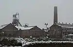
| |||
| Cockpen And Carrington Parish Church, Including Gates, Gatepiers, Boundary Wall And Letter Box | 55°51′58″N 3°05′21″W | Category A | 780 | 
| |||
| Arniston Policies, Rustic Bridge Over Gore Water | 55°50′44″N 3°04′11″W | Category B | 46124 | Upload Photo | |||
| Dalhousie Castle, Folly Tower On W Bank Of River South Esk | 55°51′34″N 3°04′52″W | Category C(S) | 46127 | 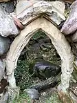
| |||
| Rosewell, The Chesters Hotel | 55°51′59″N 3°07′07″W | Category C(S) | 46140 | Upload Photo | |||
| Cockpen Farm, Folly (Tower) On E Bank Of River South Esk | 55°51′46″N 3°04′44″W | Category C(S) | 786 | Upload Photo | |||
| Bonnyrigg, Cockpen Road, Courtyard Country Inn, Dovecot And Stable Block | 55°52′05″N 3°05′36″W | Category B | 45781 | Upload Photo | |||
| Brewers Bush | 55°51′29″N 3°04′14″W | Category C(S) | 46126 | Upload Photo | |||
| Dalhousie Mains, Farmhouse And Steading, Including Gatepiers And Boundary Walls | 55°52′24″N 3°04′57″W | Category B | 46128 | Upload Photo | |||
| 1-4 (Inclusive Nos) Dalhousie Mains Cottages | 55°52′26″N 3°04′48″W | Category C(S) | 46129 | Upload Photo | |||
| Glenesk (Former Manse), Including Boundary Wall | 55°51′29″N 3°04′38″W | Category C(S) | 46131 | Upload Photo | |||
| Kirkhill Lodge, Including Gatepiers, Railings And Boundary Walls | 55°50′50″N 3°03′52″W | Category C(S) | 46135 | Upload Photo | |||
| Newtonloan, Hunterfield Road, Newtonloan Lodge, Including Gates, Gatepiers And Boundary Walls | 55°51′16″N 3°03′40″W | Category B | 44623 | Upload Photo | |||
| Dalhousie Castle | 55°51′39″N 3°04′57″W | Category A | 784 | 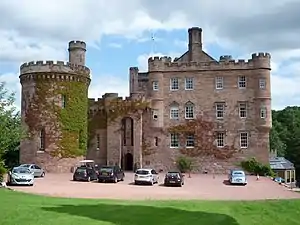
| |||
| Newtonloan, Toll House | 55°51′23″N 3°03′55″W | Category C(S) | 46138 | Upload Photo | |||
| Newbattle Abbey Policies, The King's Gate | 55°52′33″N 3°04′53″W | Category B | 789 | Upload Photo | |||
| Bonnyrigg, Cockpen Road, Courtyard Country Inn, Including Boundary Wall | 55°52′05″N 3°05′35″W | Category B | 46125 | 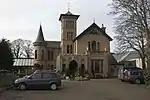
| |||
| Gorebridge, Engine Road, Emily Bank, Including Gates, Gatepiers And Boundary Walls | 55°50′51″N 3°03′35″W | Category C(S) | 46132 | Upload Photo |
Key
The scheme for classifying buildings in Scotland is:
- Category A: "buildings of national or international importance, either architectural or historic; or fine, little-altered examples of some particular period, style or building type."[1]
- Category B: "buildings of regional or more than local importance; or major examples of some particular period, style or building type, which may have been altered."[1]
- Category C: "buildings of local importance; lesser examples of any period, style, or building type, as originally constructed or moderately altered; and simple traditional buildings which group well with other listed buildings."[1]
In March 2016 there were 47,288 listed buildings in Scotland. Of these, 8% were Category A, and 50% were Category B, with the remaining 42% being Category C.[2]
Notes
- Sometimes known as OSGB36, the grid reference (where provided) is based on the British national grid reference system used by the Ordnance Survey.
• "Guide to National Grid". Ordnance Survey. Retrieved 12 December 2007.
• "Get-a-map". Ordnance Survey. Retrieved 17 December 2007. - Historic Environment Scotland assign a unique alphanumeric identifier to each designated site in Scotland, for listed buildings this always begins with "LB", for example "LB12345".
References
- All entries, addresses and coordinates are based on data from Historic Scotland. This data falls under the Open Government Licence
- "What is Listing?". Historic Environment Scotland. Retrieved 29 May 2018.
- Scotland's Historic Environment Audit 2016 (PDF). Historic Environment Scotland and the Built Environment Forum Scotland. pp. 15–16. Retrieved 29 May 2018.
This article is issued from Wikipedia. The text is licensed under Creative Commons - Attribution - Sharealike. Additional terms may apply for the media files.