List of listed buildings in Daviot and Dunlichity
List
| Name | Location | Date Listed | Grid Ref. [note 1] | Geo-coordinates | Notes | LB Number [note 2] | Image |
|---|---|---|---|---|---|---|---|
| Aberarder House Original 17th Century House Now Rear Service Quarters/Caretaker's Dwelling | 57°17′58″N 4°17′27″W | Category B | 1697 |  Upload Photo | |||
| Faillie Bridge Over Nairn River | 57°24′51″N 4°08′45″W | Category B | 1683 | Upload Photo | |||
| Flichity House | 57°19′43″N 4°12′07″W | Category B | 1684 | Upload Photo | |||
| Daviot Parish Church Of Scotland And Burial Ground | 57°25′38″N 4°07′39″W | Category B | 1700 | Upload Photo | |||
| Daviot Church Of Scotland Manse | 57°25′40″N 4°07′39″W | Category B | 1701 | Upload Photo | |||
| Daviot House (House Of Daviot) | 57°26′17″N 4°07′10″W | Category B | 1702 | Upload Photo | |||
| Dunlichity Parish Church Of Scotland, Watch-House Mcgilleveray Burial Enclosure And Burial Ground | 57°22′03″N 4°13′48″W | Category B | 1704 | Upload Photo | |||
| Farr, The Old Inn | 57°21′35″N 4°11′49″W | Category B | 1685 | Upload Photo | |||
| Culloden Moor, Memorial Cairn | 57°28′39″N 4°06′00″W | Category A | 1699 | 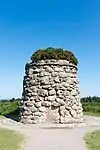
| |||
| Tordarroch Bridge Over The Nairn River | 57°22′24″N 4°12′10″W | Category B | 1707 | Upload Photo | |||
| Bridgend Farmhouse, Farm Buildings And Byre | 57°18′07″N 4°16′49″W | Category B | 42470 | Upload Photo | |||
| Daviot Mains (Including Horse Engine House) | 57°26′17″N 4°07′30″W | Category B | 1703 | Upload Photo | |||
| Dunmaglass Bridge Over River Farigaig | 57°17′22″N 4°18′40″W | Category B | 1682 | Upload Photo | |||
| Croachy, Tomintoul House | 57°19′34″N 4°13′34″W | Category B | 1698 | Upload Photo | |||
| Littlemill Bridge Over The Allt Na Fuar Ghlaic | 57°24′35″N 4°08′59″W | Category C(S) | 1705 | Upload Photo |
Key
The scheme for classifying buildings in Scotland is:
- Category A: "buildings of national or international importance, either architectural or historic; or fine, little-altered examples of some particular period, style or building type."[1]
- Category B: "buildings of regional or more than local importance; or major examples of some particular period, style or building type, which may have been altered."[1]
- Category C: "buildings of local importance; lesser examples of any period, style, or building type, as originally constructed or moderately altered; and simple traditional buildings which group well with other listed buildings."[1]
In March 2016 there were 47,288 listed buildings in Scotland. Of these, 8% were Category A, and 50% were Category B, with the remaining 42% being Category C.[2]
See also
Notes
- Sometimes known as OSGB36, the grid reference (where provided) is based on the British national grid reference system used by the Ordnance Survey.
• "Guide to National Grid". Ordnance Survey. Retrieved 12 December 2007.
• "Get-a-map". Ordnance Survey. Retrieved 17 December 2007. - Historic Environment Scotland assign a unique alphanumeric identifier to each designated site in Scotland, for listed buildings this always begins with "LB", for example "LB12345".
References
- All entries, addresses and coordinates are based on data from Historic Scotland. This data falls under the Open Government Licence
- "What is Listing?". Historic Environment Scotland. Retrieved 29 May 2018.
- Scotland's Historic Environment Audit 2016 (PDF). Historic Environment Scotland and the Built Environment Forum Scotland. pp. 15–16. Retrieved 29 May 2018.
This article is issued from Wikipedia. The text is licensed under Creative Commons - Attribution - Sharealike. Additional terms may apply for the media files.