List of listed buildings in Dingwall
List
| Name | Location | Date Listed | Grid Ref. [note 1] | Geo-coordinates | Notes | LB Number [note 2] | Image |
|---|---|---|---|---|---|---|---|
| The Castle and Roderick Maclennan Monument | Castle Street | 57°35′53″N 4°25′22″W | Category B | 24499 | .jpg.webp)
| ||
| Caisteal Gòrach | By Tulloch Castle | 57°37′00″N 4°26′18″W | Category A | 24520 | .jpg.webp)
| ||
| Free Church Of Scotland | High Street | 57°35′41″N 4°25′26″W | Category B | 24508 | .jpg.webp)
| ||
| Royal Bank Of Scotland | High Street | 57°35′42″N 4°25′29″W | Category B | 24509 | .jpg.webp)
| ||
| Dingwall Railway Station. Down And Up Platform Ranges, Down Platform Staff Shelter | Station Road | 57°35′41″N 4°25′21″W | Category B | 24514 | 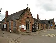
| ||
| St Clements Church (Church of Scotland Parish Church), Gatepiers And Burial Ground | Tulloch Street | 57°35′49″N 4°25′44″W | Category A | 24516 | .jpg.webp)
| ||
| Former Seaforth Sanatorium And Lodge | Maryburgh | 57°34′39″N 4°27′00″W | Category B | 6360 | 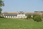
| ||
| Hydro Board (now Highland Theological College) | High Street | 57°35′43″N 4°25′26″W | Category B | 24502 | .jpg.webp)
| ||
| 63, 64 High Street | High Street | 57°35′44″N 4°25′41″W | Category B | 24505 |  Upload Photo | ||
| Tulloch Farm, Steading, Houses And Garden Wall | 57°36′35″N 4°25′47″W | Category B | 24519 | Upload Photo | |||
| Dovecote | Castle Street | 57°35′50″N 4°25′24″W | Category B | 24498 | 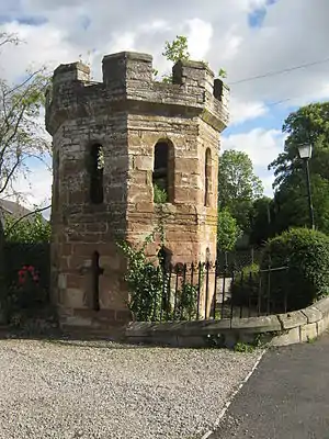
| ||
| Sheriff Court, Prison and Former Police Station | Ferry Road | 57°35′41″N 4°25′13″W | Category B | 24500 | .jpg.webp)
| ||
| 58, 59, 60 High Street and 1-2 Mcgregor's Court | 57°35′44″N 4°25′37″W | Category C(S) | 24503 | Upload Photo | |||
| Tulloch Castle and Arched Tunnel Entrance | 57°36′32″N 4°25′58″W | Category B | 24518 | .jpg.webp)
| |||
| Greenhill Street Park Garage (Former Park Cottage) | Greenhill Street | 57°35′38″N 4°25′31″W | Category B | 24521 | .jpg.webp)
| ||
| Drynie | 57°36′42″N 4°26′48″W | Category C(S) | 1822 | Upload Photo | |||
| Humberston | 57°35′05″N 4°26′06″W | Category C(S) | 1823 | Upload Photo | |||
| St Ninians | Castle Street | 57°35′46″N 4°25′29″W | Category B | 24497 | Upload Photo | ||
| Ross Memorial Hospital | Ferry Road | 57°35′39″N 4°25′04″W | Category B | 24501 | .jpg.webp)
| ||
| Town Hall | High Street | 57°35′44″N 4°25′42″W | Category B | 24506 | _Town_Hall_and_Tollbooth_in_Dingwall_Ross_%2526_Cromarty_Scotland_(2874092256).jpg.webp)
| ||
| Clydesdale Bank, Park House | High Street | 57°35′42″N 4°25′30″W | Category B | 24510 | Upload Photo | ||
| Hector Macdonald Memorial | Mitchell Hill | 57°35′33″N 4°25′44″W | Category B | 24513 | 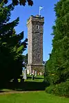
| ||
| Caledonian Hotel | High Street | 57°35′44″N 4°25′39″W | Category C(S) | 24504 | .jpg.webp)
| ||
| Mercat Cross | High Street | 57°35′44″N 4°25′42″W | Category B | 24507 | .jpg.webp)
| ||
| The Retreat | High Street | 57°35′42″N 4°25′36″W | Category B | 24511 | 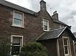
| ||
| 9 Hill Street | Hill Street | 57°35′39″N 4°25′35″W | Category B | 24512 | Upload Photo | ||
| 14 High Street | High Street | 57°35′43″N 4°25′40″W | Category C(S) | 51618 | Upload Photo | ||
| Warehouse, Former Ben Wyvis Distillery | Station Road | 57°35′26″N 4°25′26″W | Category B | 24515 | .jpg.webp)
| ||
| Cromartie Memorial, Obelisk | Tulloch Street | 57°35′49″N 4°25′41″W | Category B | 24517 | 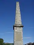 |
Key
The scheme for classifying buildings in Scotland is:
- Category A: "buildings of national or international importance, either architectural or historic; or fine, little-altered examples of some particular period, style or building type."[1]
- Category B: "buildings of regional or more than local importance; or major examples of some particular period, style or building type, which may have been altered."[1]
- Category C: "buildings of local importance; lesser examples of any period, style, or building type, as originally constructed or moderately altered; and simple traditional buildings which group well with other listed buildings."[1]
In March 2016 there were 47,288 listed buildings in Scotland. Of these, 8% were Category A, and 50% were Category B, with the remaining 42% being Category C.[2]
See also
Notes
- Sometimes known as OSGB36, the grid reference (where provided) is based on the British national grid reference system used by the Ordnance Survey.
• "Guide to National Grid". Ordnance Survey. Retrieved 12 December 2007.
• "Get-a-map". Ordnance Survey. Retrieved 17 December 2007. - Historic Environment Scotland assign a unique alphanumeric identifier to each designated site in Scotland, for listed buildings this always begins with "LB", for example "LB12345".
References
- All entries, addresses and coordinates are based on data from Historic Scotland. This data falls under the Open Government Licence
- "What is Listing?". Historic Environment Scotland. Retrieved 29 May 2018.
- Scotland's Historic Environment Audit 2016 (PDF). Historic Environment Scotland and the Built Environment Forum Scotland. pp. 15–16. Retrieved 29 May 2018.
This article is issued from Wikipedia. The text is licensed under Creative Commons - Attribution - Sharealike. Additional terms may apply for the media files.