List of listed buildings in Duthil and Rothiemurchus
List
| Name | Location | Date Listed | Grid Ref. [note 1] | Geo-coordinates | Notes | LB Number [note 2] | Image |
|---|---|---|---|---|---|---|---|
| By Dulnain Bridge Wester Finlarig House And Lodge (Service Cottage) | 57°18′39″N 3°40′43″W | Category B | 245 |  Upload Photo | |||
| Muckrach Castle | 57°18′17″N 3°41′05″W | Category A | 249 | 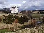
| |||
| Rothiemurchus, Episcopal Church Of St. John The Baptist And Burial Ground | 57°10′41″N 3°49′14″W | Category B | 256 | 
| |||
| Carrbridge, Duthill Parish Church, (Former United Free Church Of Scotland Now Church Of Scotland) | 57°16′52″N 3°48′49″W | Category B | 262 | Upload Photo | |||
| Aviemore, Dalfaber Road, Pine Bank (Former Craigellachie House) | 57°10′58″N 3°49′52″W | Category C(S) | 48029 | Upload Photo | |||
| Aviemore, Grampian Road, Glenspey Including Boundary Walls And Gatepiers | 57°11′46″N 3°49′46″W | Category C(S) | 48031 | Upload Photo | |||
| Carrbridge, Old Bridge Over River Dulnain | 57°17′02″N 3°48′57″W | Category B | 241 | 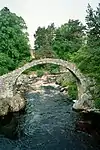
| |||
| Clury | 57°17′34″N 3°42′37″W | Category B | 242 | Upload Photo | |||
| Boat Of Garten Railway Station, Footbridge, Signal Box And Former Station Master's House | 57°14′53″N 3°45′10″W | Category B | 258 | 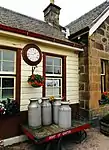
| |||
| Broomhill Bridge Over River Spey | 57°16′51″N 3°39′56″W | Category A | 260 | 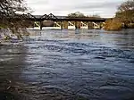
| |||
| Locomotive Shed And Offices, Strathspey Railway, Aviemore | 57°11′37″N 3°49′31″W | Category B | 43492 | 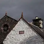
| |||
| Rothiemurchus, The Polchar | 57°09′53″N 3°50′02″W | Category B | 236 | Upload Photo | |||
| Dulnain Bridge, Bridge Over River Dulnain | 57°18′12″N 3°40′00″W | Category B | 243 | Upload Photo | |||
| Rothiemurchus, The Doune West Lodge | 57°09′26″N 3°50′42″W | Category C(S) | 255 | 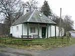
| |||
| Aviemore Railway Station With Island Platform, Footbridge And Fencing | 57°11′19″N 3°49′45″W | Category A | 257 | 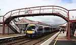
| |||
| Broomhill House | 57°16′58″N 3°40′17″W | Category B | 261 | Upload Photo | |||
| Aviemore, Grampian Road, Shelter Stone | 57°11′38″N 3°49′46″W | Category C(S) | 48032 | Upload Photo | |||
| Carrbridge Station | 57°16′47″N 3°49′41″W | Category B | 6636 | 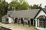
| |||
| Slochd, Ortunan Bridge | 57°17′24″N 3°55′19″W | Category C(S) | 238 | .jpg.webp)
| |||
| Kinchurdy | 57°13′19″N 3°45′54″W | Category B | 248 | Upload Photo | |||
| Rothiemurchus, The Doune Farm Cottages | 57°10′04″N 3°50′39″W | Category B | 254 | Upload Photo | |||
| Dulnain Bridge, Skye Of Curr Hotel (Formerly Tigh-Na-Sgiadh) Including Boundary Wall And Gatepiers To Se | 57°18′08″N 3°40′24″W | Category B | 49528 | Upload Photo | |||
| Rothiemurchus, Old Church And Burial Ground | 57°09′39″N 3°50′38″W | Category B | 234 | Upload Photo | |||
| Duthill, Seafield Mausolea | 57°17′49″N 3°46′05″W | Category B | 247 | 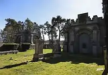
| |||
| Rothiemurchus, The Doune | 57°09′55″N 3°50′37″W | Category B | 253 | 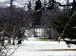
| |||
| Strathspey Boat Of Garten, Deishar Road, | 57°14′55″N 3°45′18″W | Category C(S) | 259 | Upload Photo | |||
| Loch An Eilein, Lime Kiln Cottage and Lime Kiln | 57°08′51″N 3°49′30″W | Category C(S) | 6648 | 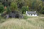
| |||
| Rothiemurchus, St. Columba's Church (Former Free Church then Church Of Scotland) | 57°10′32″N 3°48′57″W | Category B | 233 | 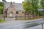
| |||
| By Slochd, Bridge Over Allt Slochd Mhuic | 57°16′35″N 3°55′17″W | Category B | 239 | 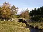
| |||
| Sluggan Bridge Over River Dulnain | 57°16′29″N 3°52′33″W | Category A | 240 | 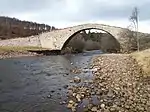
| |||
| Rothiemurchus, James Martineau Memorial | 57°09′52″N 3°50′09″W | Category C(S) | 250 | .jpg.webp)
| |||
| Carrbridge, Village Hall | 57°16′54″N 3°48′50″W | Category B | 263 | .jpg.webp)
| |||
| Rothiemurchus, Old Manse | 57°09′49″N 3°49′52″W | Category B | 235 | Upload Photo | |||
| By Dulnain Bridge, Garth Of Finlarig | 57°18′38″N 3°40′34″W | Category C(S) | 244 | Upload Photo | |||
| Duthill, Old Parish Church, Burial Ground | 57°17′49″N 3°46′06″W | Category B | 246 | .JPG.webp)
| |||
| Rothiemurchus, Dell Steading (Rothiemurchus Estate Office) | 57°10′48″N 3°48′51″W | Category B | 252 | .jpg.webp)
| |||
| Aviemore, Grampian Road, Cairngorm Hotel | 57°11′18″N 3°49′48″W | Category C(S) | 48030 | .jpg.webp)
| |||
| Slochd Mhuic Railway Viaduct | 57°17′24″N 3°54′56″W | Category B | 237 | .jpg.webp)
| |||
| Rothiemurchus, Croft House | 57°09′42″N 3°48′56″W | Category A | 251 | Upload Photo | |||
| Aviemore Railway Station, Signal Box | 57°11′31″N 3°49′40″W | Category B | 52063 | 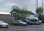 |
Key
The scheme for classifying buildings in Scotland is:
- Category A: "buildings of national or international importance, either architectural or historic; or fine, little-altered examples of some particular period, style or building type."[1]
- Category B: "buildings of regional or more than local importance; or major examples of some particular period, style or building type, which may have been altered."[1]
- Category C: "buildings of local importance; lesser examples of any period, style, or building type, as originally constructed or moderately altered; and simple traditional buildings which group well with other listed buildings."[1]
In March 2016 there were 47,288 listed buildings in Scotland. Of these, 8% were Category A, and 50% were Category B, with the remaining 42% being Category C.[2]
See also
Notes
- Sometimes known as OSGB36, the grid reference (where provided) is based on the British national grid reference system used by the Ordnance Survey.
• "Guide to National Grid". Ordnance Survey. Retrieved 12 December 2007.
• "Get-a-map". Ordnance Survey. Retrieved 17 December 2007. - Historic Environment Scotland assign a unique alphanumeric identifier to each designated site in Scotland, for listed buildings this always begins with "LB", for example "LB12345".
References
- All entries, addresses and coordinates are based on data from Historic Scotland. This data falls under the Open Government Licence
- "What is Listing?". Historic Environment Scotland. Retrieved 29 May 2018.
- Scotland's Historic Environment Audit 2016 (PDF). Historic Environment Scotland and the Built Environment Forum Scotland. pp. 15–16. Retrieved 29 May 2018.
This article is issued from Wikipedia. The text is licensed under Creative Commons - Attribution - Sharealike. Additional terms may apply for the media files.