List of listed buildings in Fetteresso, Aberdeenshire
List
| Name | Location | Date Listed | Grid Ref. [note 1] | Geo-coordinates | Notes | LB Number [note 2] | Image |
|---|---|---|---|---|---|---|---|
| Muchalls, Marine Hotel | 57°01′05″N 2°09′52″W | Category B | 44607 |  Upload Photo | |||
| Old Schoolhouse, Bridge Of Muchalls | 57°00′46″N 2°10′50″W | Category C(S) | 9351 | Upload Photo | |||
| 1-7 Monduff Road Formerly 3-6 Main Street, Stranathro | 57°01′17″N 2°09′41″W | Category C(S) | 9355 | Upload Photo | |||
| Ury - North Lodge | 56°59′28″N 2°12′55″W | Category B | 9376 | 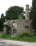
| |||
| Rickarton House | 56°59′18″N 2°16′04″W | Category B | 9378 | Upload Photo | |||
| Rickarton House - Bridge Over Cowton Burn | 56°59′26″N 2°16′10″W | Category C(S) | 9379 | Upload Photo | |||
| Cowton Bridge Over Cowton Burn | 56°59′43″N 2°17′04″W | Category C(S) | 9380 | Upload Photo | |||
| Auquhollie Bridge Over Small Burn | 57°00′12″N 2°17′09″W | Category C(S) | 9381 | Upload Photo | |||
| Newtonhill, 13 Skateraw Road | 57°01′56″N 2°08′53″W | Category C(S) | 13484 | Upload Photo | |||
| Bridge Of Muchalls Over Muchalls Burn | 57°00′39″N 2°10′34″W | Category C(S) | 9350 | Upload Photo | |||
| Lairhillock Bridge Over Monquich Burn | 57°02′51″N 2°14′41″W | Category C(S) | 9362 | Upload Photo | |||
| Ury - Bridge Over Cowie Water | 56°58′53″N 2°14′23″W | Category C(S) | 9374 | Upload Photo | |||
| Ury Estate, Baille Na Choile Including Terrace Wall And Boundary Wall | 56°58′57″N 2°14′06″W | Category C(S) | 49608 | Upload Photo | |||
| Ury Estate, Blue Lodge | 56°58′44″N 2°14′35″W | Category C(S) | 49610 | Upload Photo | |||
| Netherley House Hotel | 57°02′06″N 2°15′18″W | Category B | 9360 | 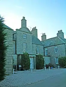
| |||
| Ury, Houff Enclosing Walls | 56°59′29″N 2°14′19″W | Category C(S) | 6743 | Upload Photo | |||
| Fetteresso Castle, Fetteresso Walled Garden, Including Summer House | 56°57′36″N 2°15′47″W | Category C(S) | 46514 | Upload Photo | |||
| Ury Estate, Blue Gate Including Quadrant Walls | 56°58′43″N 2°14′35″W | Category C(S) | 49609 | Upload Photo | |||
| Slug Road, New Lodge Boundary Walls And Gatepiers | 56°58′19″N 2°13′30″W | Category C(S) | 49615 | Upload Photo | |||
| Kirkton Inn Bridge Over Cheyne Burn | 56°57′45″N 2°14′32″W | Category B | 9369 | Upload Photo | |||
| Cheyne Farmhouse | 56°58′22″N 2°15′32″W | Category B | 9372 | Upload Photo | |||
| Ury - Houff Mausoleum | 56°59′29″N 2°14′20″W | Category C(S) | 9375 | Upload Photo | |||
| Ury Estate, Viaduct Over Cowie Water | 56°58′52″N 2°14′22″W | Category B | 49613 | Upload Photo | |||
| Newtonhill, 15 Skateraw Road, St Margaret's Cottage | 57°01′55″N 2°08′52″W | Category C(S) | 13483 | Upload Photo | |||
| Cowie Mains Steading | 56°58′21″N 2°12′15″W | Category C(S) | 9349 | Upload Photo | |||
| Muchalls Castle - Doocot | 57°01′02″N 2°10′50″W | Category B | 9354 | Upload Photo | |||
| Netherley Bridge Over Monquich Burn | 57°02′15″N 2°14′52″W | Category C(S) | 9359 | Upload Photo | |||
| Kirkyard Walls | 56°57′44″N 2°14′36″W | Category B | 9366 | Upload Photo | |||
| Cowie Chapel | 56°58′37″N 2°11′32″W | Category B | 9382 | Upload Photo | |||
| Cowie Chapel - Dead-House | 56°58′37″N 2°11′32″W | Category B | 9383 | 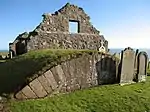
| |||
| Cowie House | 56°58′30″N 2°11′59″W | Category B | 9384 | Upload Photo | |||
| Cowie House, Enclosure Walls | 56°58′31″N 2°11′54″W | Category C(S) | 9386 | Upload Photo | |||
| Ury Estate, Ice House | 56°58′52″N 2°13′55″W | Category C(S) | 49612 | Upload Photo | |||
| Slug Road, South Lodge Including Boundary Walls And Gatepiers | 56°58′19″N 2°13′30″W | Category C(S) | 49616 | Upload Photo | |||
| Muchalls Castle, Coach House And Stables, Including Pump | 57°01′03″N 2°10′51″W | Category B | 13477 | Upload Photo | |||
| Muchalls Castle | 57°01′03″N 2°10′47″W | Category A | 9352 | Upload Photo | |||
| Berryhill House | 57°02′58″N 2°09′43″W | Category B | 9357 | Upload Photo | |||
| Netherley House - Bridge Over Monquich Burn | 57°02′07″N 2°15′10″W | Category C(S) | 9361 | Upload Photo | |||
| Newtonhill Skateraw Road Old Smokehouse | 57°01′54″N 2°08′48″W | Category C(S) | 9363 | Upload Photo | |||
| Ury House And Terrace Walls | 56°58′50″N 2°13′58″W | Category B | 9364 | Upload Photo | |||
| South Of Old Kirkton Inn | 56°57′44″N 2°14′33″W | Category B | 9368 | Upload Photo | |||
| Findlayston Bridge Over Cowie Water | 56°59′10″N 2°15′37″W | Category B | 9377 | Upload Photo | |||
| Ury Estate, Bridge Over Ury Burn | 56°58′51″N 2°13′54″W | Category C(S) | 49611 | Upload Photo | |||
| Newhall House | 57°02′20″N 2°11′35″W | Category B | 9356 | 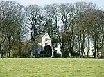
| |||
| Old Kirkton Inn | 56°57′45″N 2°14′33″W | Category B | 9367 | Upload Photo | |||
| Muchalls Castle, Gardener's Cottage | 57°01′02″N 2°10′52″W | Category C(S) | 13478 | Upload Photo | |||
| Muchalls Castle - "The Crypt" | 57°01′03″N 2°10′47″W | Category B | 9353 | Upload Photo | |||
| Cookney Church (Of Scotland) | 57°01′50″N 2°12′50″W | Category C(S) | 9358 | 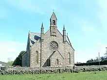
| |||
| Fetteresso Old Parish Kirk | 56°57′43″N 2°14′36″W | Category B | 9365 | Upload Photo | |||
| Fetteresso Bridge Over Carron Water | 56°57′40″N 2°14′37″W | Category B | 9370 | Upload Photo | |||
| Fetteresso Castle - Doocot | 56°57′34″N 2°15′30″W | Category A | 9371 | Upload Photo | |||
| Fetteresso Castle | 56°57′37″N 2°15′37″W | Category B | 9373 | Upload Photo | |||
| Cowie House, Offices | 56°58′31″N 2°12′00″W | Category B | 9385 | Upload Photo | |||
| Cowie Mains Farmhouse | 56°58′20″N 2°12′16″W | Category C(S) | 9387 | Upload Photo | |||
| Rickarton House, Gardener's Cottage | 56°59′17″N 2°16′09″W | Category C(S) | 6745 | Upload Photo | |||
| Ury Estate, Walled Garden | 56°58′55″N 2°14′10″W | Category C(S) | 49614 | Upload Photo |
Key
The scheme for classifying buildings in Scotland is:
- Category A: "buildings of national or international importance, either architectural or historic; or fine, little-altered examples of some particular period, style or building type."[1]
- Category B: "buildings of regional or more than local importance; or major examples of some particular period, style or building type, which may have been altered."[1]
- Category C: "buildings of local importance; lesser examples of any period, style, or building type, as originally constructed or moderately altered; and simple traditional buildings which group well with other listed buildings."[1]
In March 2016 there were 47,288 listed buildings in Scotland. Of these, 8% were Category A, and 50% were Category B, with the remaining 42% being Category C.[2]
Notes
- Sometimes known as OSGB36, the grid reference (where provided) is based on the British national grid reference system used by the Ordnance Survey.
• "Guide to National Grid". Ordnance Survey. Retrieved 12 December 2007.
• "Get-a-map". Ordnance Survey. Retrieved 17 December 2007. - Historic Environment Scotland assign a unique alphanumeric identifier to each designated site in Scotland, for listed buildings this always begins with "LB", for example "LB12345".
References
- All entries, addresses and coordinates are based on data from Historic Scotland. This data falls under the Open Government Licence
- "What is Listing?". Historic Environment Scotland. Retrieved 29 May 2018.
- Scotland's Historic Environment Audit 2016 (PDF). Historic Environment Scotland and the Built Environment Forum Scotland. pp. 15–16. Retrieved 29 May 2018.
This article is issued from Wikipedia. The text is licensed under Creative Commons - Attribution - Sharealike. Additional terms may apply for the media files.