List of listed buildings in Fortrose, Highland
List
| Name | Location | Date Listed | Grid Ref. [note 1] | Geo-coordinates | Notes | LB Number [note 2] | Image |
|---|---|---|---|---|---|---|---|
| 4 Bridge Street | Rosemarkie | 57°35′32″N 4°06′57″W | Category C(S) | 31842 |  Upload Photo | ||
| High Street Groam Cottage | Rosemarkie | 57°35′29″N 4°06′53″W | Category C(S) | 31849 | Upload Photo | ||
| Rosmarkie, 48 High Street, The Plough Inn | Rosemarkie | 57°35′31″N 4°06′54″W | Category C(S) | 31863 | .jpg.webp)
| ||
| Chanonry Ice House | Chanonry Point | 57°34′28″N 4°05′48″W | Category C(S) | 31798 | .jpg.webp)
| ||
| Chanonry Pier | Chanonry Point | 57°34′24″N 4°05′38″W | Category C(S) | 31800 | 
| ||
| 12 Academy Street, Ruthven | Fortrose | 57°34′50″N 4°07′53″W | Category B | 31805 | Upload Photo | ||
| Canonbury Terrace Craigdhu | Fortrose | 57°34′44″N 4°08′20″W | Category C(S) | 31811 | Upload Photo | ||
| 3 Cathedral Square (Springfield) And 24 High Street And Post Office | Fortrose | 57°34′52″N 4°07′55″W | Category B | 31814 | Upload Photo | ||
| 7 Cathedral Square Town House | Fortrose | 57°34′53″N 4°07′52″W | Category B | 31815 | 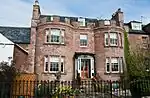
| ||
| 22 High Street | Fortrose | 57°34′52″N 4°07′55″W | Category B | 31828 | Upload Photo | ||
| 3 And 4 The Shore (Rose Cottage And Fuschia Cottage) | Fortrose | 57°34′46″N 4°08′02″W | Category C(S) | 31836 | Upload Photo | ||
| 8 (Fulmar) And 10 Bridge Street | Rosemarkie | 57°35′33″N 4°06′59″W | Category C(S) | 31840 | Upload Photo | ||
| 1 High Street (Ellan Donan) | Rosemarkie | 57°35′24″N 4°06′56″W | Category B | 31843 | Upload Photo | ||
| 28 High Street | Rosemarkie | 57°35′28″N 4°06′54″W | Category C(S) | 31851 | Upload Photo | ||
| 26 High Street | Rosemarkie | 57°35′27″N 4°06′54″W | Category C(S) | 31852 | Upload Photo | ||
| Ferry House | Chanonry Point | 57°34′26″N 4°05′38″W | Category C(S) | 31797 | .jpg.webp)
| ||
| Chanonry Lighthouse, Keeper's House, Wall And Gatepiers | Chanonry Point | 57°34′27″N 4°05′34″W | Category A | 31799 | 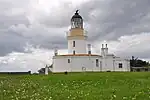
| ||
| 4 Academy Street Flowerburn Cottage | Fortrose | 57°34′50″N 4°07′54″W | Category C(S) | 31807 | Upload Photo | ||
| Harbour Road, Former West End Stores | Fortrose | 57°34′43″N 4°08′12″W | Category C(S) | 31819 | Upload Photo | ||
| 15 High Street Woodside, And Walls | Fortrose | 57°34′51″N 4°08′01″W | Category C(S) | 31820 | Upload Photo | ||
| 17 And 19 And 21 High Street | Fortrose | 57°34′51″N 4°07′59″W | Category B | 31821 | Upload Photo | ||
| 9 Union Street | Fortrose | 57°34′51″N 4°07′44″W | Category B | 31837 | Upload Photo | ||
| Union Street And High Street Royal Hotel (The Anderson) | Fortrose | 57°34′54″N 4°07′50″W | Category B | 31839 | .jpg.webp)
| ||
| 8 High Street Duart | Rosemarkie | 57°35′25″N 4°06′55″W | Category C(S) | 31858 | Upload Photo | ||
| Academy Street, St Andrew's Episcopal Church | Fortrose | 57°34′47″N 4°07′46″W | Category B | 31803 | .jpg.webp)
| ||
| Academy Street Meadow Bank, And Out-Buildings, Walls And Gate Piers | Fortrose | 57°34′49″N 4°07′50″W | Category B | 31804 | Upload Photo | ||
| 6 Canonbury Terrace, Brae House | Fortrose | 57°34′47″N 4°08′09″W | Category C(S) | 31808 | Upload Photo | ||
| 10 Canonbury Terrace (Canonbury House) | Fortrose | 57°34′45″N 4°08′11″W | Category B | 31809 | Upload Photo | ||
| Cathedral Square, Fortrose Cathedral (Ss. Peter And Bonifacius Graveyard And Walls | Fortrose | 57°34′51″N 4°07′50″W | Category A | 31812 | Upload Photo | ||
| Church Street Platcock House | Fortrose | 57°35′01″N 4°07′56″W | Category B | 31818 | Upload Photo | ||
| 32 High Street And 8 Cathedral Square Dromquinna | Fortrose | 57°34′53″N 4°07′52″W | Category B | 31827 | Upload Photo | ||
| High Street Groam House | Rosemarkie | 57°35′29″N 4°06′54″W | Category B | 31848 | .jpg.webp)
| ||
| 12 And 14 High Street (K Cumming, Butcher) | Rosemarkie | 57°35′26″N 4°06′55″W | Category C(S) | 31856 | Upload Photo | ||
| Mansebrae Gollanhead House And Gollanhead Cottage | Rosemarkie | 57°35′23″N 4°07′00″W | Category C(S) | 31860 | Upload Photo | ||
| Mansebrae Old Manse Steading | Rosemarkie | 57°35′17″N 4°07′08″W | Category C(S) | 31862 | Upload Photo | ||
| Academy Street, The Deanery And Garden Pavilion And Gatepiers And Garden Wall | Fortrose | 57°34′48″N 4°07′45″W | Category B | 31802 | Upload Photo | ||
| 23 High Street Bank Of Scotland | Fortrose | 57°34′52″N 4°07′58″W | Category B | 31822 | Upload Photo | ||
| 2 High Street The Anchorage | Fortrose | 57°34′47″N 4°08′05″W | Category B | 31831 | Upload Photo | ||
| Ness Road Ness Cottage | Fortrose | 57°34′53″N 4°06′46″W | Category C(S) | 31833 | Upload Photo | ||
| The Shore The Harbour | Fortrose | 57°34′42″N 4°08′02″W | Category B | 31835 | .jpg.webp)
| ||
| 6 Bridge Street | Rosemarkie | 57°35′32″N 4°06′58″W | Category C(S) | 31841 | Upload Photo | ||
| 3 And 5 High Street | Rosemarkie | 57°35′25″N 4°06′56″W | Category C(S) | 31844 | Upload Photo | ||
| 25 High Street (Mendoza) | Rosemarkie | 57°35′28″N 4°06′55″W | Category B | 31847 | Upload Photo | ||
| 22 High Street Glencairn | Rosemarkie | 57°35′27″N 4°06′54″W | Category C(S) | 31855 | Upload Photo | ||
| 6 High Street | Rosemarkie | 57°35′25″N 4°06′55″W | Category C(S) | 31859 | Upload Photo | ||
| Mansebrae, The Old Manse | Rosemarkie | 57°35′18″N 4°07′06″W | Category B | 31861 | Upload Photo | ||
| K6 Telephone Kiosk Adjacent To Entry To Cathedral | Fortrose | 57°34′54″N 4°07′51″W | Category B | 31864 | Upload Photo | ||
| 8 And 10 Academy Street, Seaforth Place | Fortrose | 57°34′50″N 4°07′53″W | Category B | 31806 | Upload Photo | ||
| Cathedral Square Chapter House | Fortrose | 57°34′51″N 4°07′48″W | Category A | 31813 | Upload Photo | ||
| Church Street, Town Hall | Fortrose | 57°34′57″N 4°07′54″W | Category B | 31817 | .jpg.webp)
| ||
| 33 High Street | Fortrose | 57°34′53″N 4°07′55″W | Category C(S) | 31823 | Upload Photo | ||
| 2 And 4 Rose Street, Angel Court And Rose Court | Fortrose | 57°34′49″N 4°07′46″W | Category B | 31834 | Upload Photo | ||
| Academy Street Fortrose Academy | Fortrose | 57°34′47″N 4°07′39″W | Category C(S) | 31801 | Upload Photo | ||
| Canonbury Terrace Kindeace Lodge | Fortrose | 57°34′44″N 4°08′13″W | Category B | 31810 | Upload Photo | ||
| High Street Market Cross (Corner High Street And Academy Street | Fortrose | 57°34′51″N 4°07′56″W | Category B | 31829 | .jpg.webp)
| ||
| 6 High Street (Kingarth) | Fortrose | 57°34′48″N 4°08′04″W | Category C(S) | 31830 | Upload Photo | ||
| 11 Union Street | Fortrose | 57°34′51″N 4°07′44″W | Category B | 31838 | Upload Photo | ||
| 21 And 23 High Street | Rosemarkie | 57°35′28″N 4°06′55″W | Category B | 31846 | Upload Photo | ||
| High Street Ballmungie House | Rosemarkie | 57°35′28″N 4°06′54″W | Category C(S) | 31850 | Upload Photo | ||
| High Street Rosemarkie Parish Church | Rosemarkie | 57°35′28″N 4°06′51″W | Category B | 31853 | .jpg.webp)
| ||
| High Street, Parish Churchyard Wall, Gates And Gatepiers | Rosemarkie | 57°35′27″N 4°06′53″W | Category B | 31854 | Upload Photo | ||
| St Peter and St Boniface RC Church (formerly the Drill Hall and later the Mackerchar Hall), Cathedral Square | Fortrose | 57°34′53″N 4°07′50″W | Category B | 31816 | .jpg.webp)
| ||
| 43 High Street | Fortrose | 57°34′53″N 4°07′53″W | Category C(S) | 31824 | Upload Photo | ||
| 45 High Street (Alexander's Bakery) | Fortrose | 57°34′53″N 4°07′53″W | Category C(S) | 31825 | Upload Photo | ||
| Ness Road Ness House | Fortrose | 57°34′54″N 4°06′45″W | Category B | 31832 | Upload Photo | ||
| 7, 9 And 11 High Street | Rosemarkie | 57°35′26″N 4°06′56″W | Category B | 31845 | Upload Photo | ||
| 10 High Street Fyvie | Rosemarkie | 57°35′26″N 4°06′55″W | Category C(S) | 31857 | Upload Photo | ||
| High Street, Fortrose Parish Church | Fortrose | 57°34′59″N 4°07′45″W | Category B | 31826 | .jpg.webp) |
Key
The scheme for classifying buildings in Scotland is:
- Category A: "buildings of national or international importance, either architectural or historic; or fine, little-altered examples of some particular period, style or building type."[1]
- Category B: "buildings of regional or more than local importance; or major examples of some particular period, style or building type, which may have been altered."[1]
- Category C: "buildings of local importance; lesser examples of any period, style, or building type, as originally constructed or moderately altered; and simple traditional buildings which group well with other listed buildings."[1]
In March 2016 there were 47,288 listed buildings in Scotland. Of these, 8% were Category A, and 50% were Category B, with the remaining 42% being Category C.[2]
See also
Notes
- Sometimes known as OSGB36, the grid reference (where provided) is based on the British national grid reference system used by the Ordnance Survey.
• "Guide to National Grid". Ordnance Survey. Retrieved 12 December 2007.
• "Get-a-map". Ordnance Survey. Retrieved 17 December 2007. - Historic Environment Scotland assign a unique alphanumeric identifier to each designated site in Scotland, for listed buildings this always begins with "LB", for example "LB12345".
References
- All entries, addresses and coordinates are based on data from Historic Scotland. This data falls under the Open Government Licence
- "What is Listing?". Historic Environment Scotland. Retrieved 29 May 2018.
- Scotland's Historic Environment Audit 2016 (PDF). Historic Environment Scotland and the Built Environment Forum Scotland. pp. 15–16. Retrieved 29 May 2018.
This article is issued from Wikipedia. The text is licensed under Creative Commons - Attribution - Sharealike. Additional terms may apply for the media files.