List of listed buildings in Gairloch, Highland
List
| Name | Location | Date Listed | Grid Ref. [note 1] | Geo-coordinates | Notes | LB Number [note 2] | Image |
|---|---|---|---|---|---|---|---|
| Midtown, Inverasdale,School,Former Free Church | 57°48′04″N 5°40′06″W | Category B | 12919 |  Upload Photo | |||
| Badachro,Aird House | 57°42′08″N 5°43′32″W | Category C(S) | 12920 | Upload Photo | |||
| Badachro Inn,Badachro,With Boathouse And Jetties | 57°41′55″N 5°43′23″W | Category B | 12921 | Upload Photo | |||
| South Erradale Causeway Over River Erradale (On B8056 Road) | 57°40′29″N 5°47′07″W | Category B | 7901 | Upload Photo | |||
| Flowerdale House (Including Westerdale) And Walled Garden | 57°42′53″N 5°40′17″W | Category A | 7910 | .jpg.webp)
| |||
| Gairloch, Strath, Strathgair House Steading And Walled Garden | 57°43′56″N 5°41′55″W | Category C(S) | 7887 | Upload Photo | |||
| Letterewe Furnace Cottage | 57°40′38″N 5°25′24″W | Category C(S) | 7893 | Upload Photo | |||
| 3 Mellon Udrigle | 57°54′14″N 5°33′39″W | Category B | 7894 | Upload Photo | |||
| Poolewe The Old Manse | 57°45′36″N 5°35′52″W | Category C(S) | 7897 | Upload Photo | |||
| Rubha Reidh Lighthouse | 57°51′38″N 5°48′27″W | Category B | 49894 | .jpg.webp)
| |||
| Charleston House | 57°42′37″N 5°40′42″W | Category B | 12917 | Upload Photo | |||
| Poolewe Cliff House | 57°46′02″N 5°36′32″W | Category B | 7898 | Upload Photo | |||
| Kerrysdale House | 57°41′51″N 5°39′25″W | Category C(S) | 7889 | Upload Photo | |||
| Gairloch Old Kirkyard | 57°43′13″N 5°41′12″W | Category B | 12918 | Upload Photo | |||
| Poolewe Srondubh House And Former Steading | 57°46′14″N 5°35′47″W | Category B | 7900 | Upload Photo | |||
| 27 Big Sand, House And Outbuilding | 57°44′43″N 5°46′47″W | Category B | 7908 | Upload Photo | |||
| Gairloch Parish Church, Church Of Scotland | 57°42′59″N 5°40′58″W | Category C(S) | 7885 | .jpg.webp)
| |||
| 11 Melvaig | 57°48′42″N 5°48′03″W | Category B | 7895 | Upload Photo | |||
| Badachro, Eilean Tioram (Dry Island), Former Fishing Station Including House And Jetty | 57°42′04″N 5°43′31″W | Category B | 12925 | Upload Photo | |||
| Letterewe Watch House (Now Garden Store) | 57°41′06″N 5°26′17″W | Category B | 7891 | Upload Photo | |||
| Letterewe Steading | 57°41′06″N 5°26′13″W | Category C(S) | 7892 | Upload Photo | |||
| Poolewe Parish Church. Church Of Scotland | 57°46′00″N 5°36′17″W | Category B | 7896 | 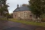
| |||
| Aultbea, Bridge Over Allt Beithe | 57°50′23″N 5°35′01″W | Category C(S) | 7907 | Upload Photo | |||
| Charleston Bridge | 57°42′46″N 5°40′38″W | Category C(S) | 7909 | .jpg.webp)
| |||
| Gairloch Free Church Of Scotland | 57°43′13″N 5°41′14″W | Category B | 7886 | .jpg.webp)
| |||
| Letterewe House And Rear Service | 57°41′07″N 5°26′17″W | Category C(S) | 7890 | Upload Photo | |||
| Poolewe Bridge Over River Ewe | 57°45′57″N 5°36′12″W | Category B | 7899 | Upload Photo | |||
| Flowerdale Barn | 57°42′50″N 5°40′13″W | Category B | 7884 | 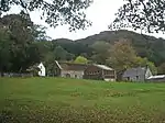
| |||
| Gairloch The Old Police Station | 57°43′42″N 5°41′27″W | Category C(S) | 7888 | Upload Photo | |||
| Tollie (Clapper) Bridge Over Allt A'Pholl-Choire To Nw Of Tollie Farm | 57°44′52″N 5°35′47″W | Category B | 46976 | Upload Photo | |||
| Udrigle House | 57°52′56″N 5°33′03″W | Category A | 7902 | Upload Photo |
Key
The scheme for classifying buildings in Scotland is:
- Category A: "buildings of national or international importance, either architectural or historic; or fine, little-altered examples of some particular period, style or building type."[1]
- Category B: "buildings of regional or more than local importance; or major examples of some particular period, style or building type, which may have been altered."[1]
- Category C: "buildings of local importance; lesser examples of any period, style, or building type, as originally constructed or moderately altered; and simple traditional buildings which group well with other listed buildings."[1]
In March 2016 there were 47,288 listed buildings in Scotland. Of these, 8% were Category A, and 50% were Category B, with the remaining 42% being Category C.[2]
See also
Notes
- Sometimes known as OSGB36, the grid reference (where provided) is based on the British national grid reference system used by the Ordnance Survey.
• "Guide to National Grid". Ordnance Survey. Retrieved 12 December 2007.
• "Get-a-map". Ordnance Survey. Retrieved 17 December 2007. - Historic Environment Scotland assign a unique alphanumeric identifier to each designated site in Scotland, for listed buildings this always begins with "LB", for example "LB12345".
References
- All entries, addresses and coordinates are based on data from Historic Scotland. This data falls under the Open Government Licence
- "What is Listing?". Historic Environment Scotland. Retrieved 29 May 2018.
- Scotland's Historic Environment Audit 2016 (PDF). Historic Environment Scotland and the Built Environment Forum Scotland. pp. 15–16. Retrieved 29 May 2018.
This article is issued from Wikipedia. The text is licensed under Creative Commons - Attribution - Sharealike. Additional terms may apply for the media files.