List of listed buildings in Glasgow/7
List
| Name | Location | Date Listed | Grid Ref. [note 1] | Geo-coordinates | Notes | LB Number [note 2] | Image |
|---|---|---|---|---|---|---|---|
| 2 Lancaster Crescent, 2 Lancaster Crescent Lane; Great Western Road | 55°52′57″N 4°18′09″W | Category B | 32555 |  Upload Photo | |||
| 1-3 (Inclusive Nos) Lancaster Terrace And Gatepiers, Great Western Road | 55°52′54″N 4°18′10″W | Category B | 32558 | Upload Photo | |||
| 14-16 (Even Nos) Mirrlees Drive And 18-20 (Even Nos) Mirrlees Drive | 55°52′56″N 4°17′51″W | Category C(S) | 32569 | Upload Photo | |||
| 124 Observatory Road, Elmslea | 55°52′42″N 4°17′49″W | Category B | 32570 | Upload Photo | |||
| 2-8 (Even Nos) Kensington Road And Boundary Walls | 55°52′47″N 4°18′01″W | Category B | 32538 | Upload Photo | |||
| 2-14 (Even Nos) Dowanside Road | 55°52′30″N 4°17′41″W | Category C(S) | 32501 | Upload Photo | |||
| 27-29 (Odd Nos) Dundonald Road, St Lukes Greek Orthodox Cathedral | 55°52′45″N 4°17′57″W | Category B | 32508 | 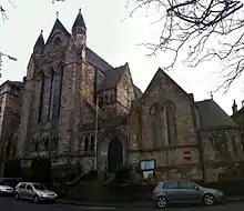
| |||
| 985 Great Western Road (Westbourne House) With 11 Hyndland Road With Retaining Walls | 55°52′56″N 4°18′12″W | Category B | 32516 | Upload Photo | |||
| 1-9 (Inclusive Nos) Bowmont Terrace | 55°52′37″N 4°17′50″W | Category B | 32481 | Upload Photo | |||
| Daisy Street, Govanhill Church Of Scotland | 55°50′10″N 4°15′31″W | Category B | 32430 | 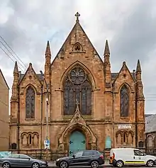
| |||
| 34 Dixon Avenue, Langside Road, Maxwell Exhibitions Ltd. (Former Crosshill Victoria Church And Hall) | 55°50′05″N 4°15′46″W | Category B | 32431 | Upload Photo | |||
| 120-142 (Even Nos) Queen's Drive, 538-540 (Even Nos) Victoria Road And 3, 5 Maybank Street Including Railings | 55°50′03″N 4°16′02″W | Category B | 32454 | 
| |||
| 170 Queen's Drive And Albert Avenue, Strathbungo Queen's Park Church Including Hall | 55°50′05″N 4°16′10″W | Category B | 32457 | 
| |||
| 401-407 (Odd Nos) Victoria Road, Allison Street, Victoria Cross Building | 55°50′11″N 4°15′52″W | Category B | 32459 | 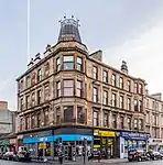
| |||
| Victoria Road Gateway To Queen's Park Including Gatepiers Gates And Railings | 55°50′00″N 4°15′57″W | Category B | 32414 | 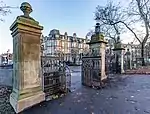
| |||
| 84 Albert Road Sunnybank | 55°50′01″N 4°15′41″W | Category B | 32421 | 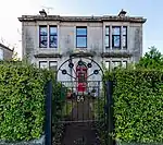
| |||
| 83 Craigie Street, St Bride's Primary School, Former Strathbungo Public School Including Janitor's Lodge Gatepiers And Railings | 55°50′12″N 4°15′59″W | Category B | 32428 | 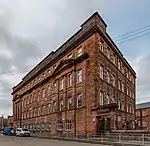
| |||
| Battle Place, Battlefield Monument | 55°49′40″N 4°16′14″W | Category B | 32360 | 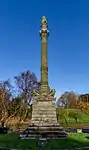
| |||
| 55 Battlefield Road, Grange Road Battlefield Rest | 55°49′38″N 4°15′59″W | Category B | 32361 | 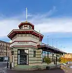
| |||
| 1 Langside Avenue, Langside Hall | 55°49′53″N 4°16′39″W | Category A | 32369 | 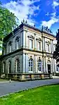
| |||
| Millbrae Bridge (Langside Drive - Millbrae Road Over White Cart Water) | 55°49′20″N 4°16′39″W | Category B | 32383 | Upload Photo | |||
| 41 Nithsdale Drive, Nithsdale Hall Including Gatepiers | 55°50′16″N 4°16′10″W | Category B | 32390 | Upload Photo | |||
| 11-69 (Odd Nos) Nithsdale Road | 55°50′11″N 4°16′17″W | Category B | 32393 | 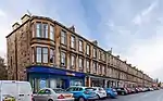
| |||
| 40-46 (Even Nos) Nithsdale Street | 55°50′15″N 4°16′16″W | Category C(S) | 32396 | Upload Photo | |||
| 64 Randolph Road, Marlborough Avenue, 4 Rowallan Lane, Broomhill Church And Halls (Church Of Scotland) | 55°52′41″N 4°19′14″W | Category C(S) | 32296 | Upload Photo | |||
| 3 And 5 Arnwood Drive (Westwood And St Brendan) | 55°53′08″N 4°19′03″W | Category B | 32300 | Upload Photo | |||
| 45 Chamberlain Road, Jordanhill Training College Demonstration School, Lodge, Gates, Gatepiers And Quadrant Walls | 55°53′06″N 4°20′01″W | Category B | 32303 | Upload Photo | |||
| 50 Cleveden Drive Boundary Walls And Gatepiers | 55°53′02″N 4°18′16″W | Category B | 32307 | Upload Photo | |||
| 52 Cleveden Drive, Boundary Walls And Gatepiers | 55°53′03″N 4°18′18″W | Category B | 32308 | Upload Photo | |||
| 56 Cleveden Drive "Westmount", Boundary Walls And Gatepiers | 55°53′04″N 4°18′21″W | Category B | 32310 | Upload Photo | |||
| 1055 Great Western Road, Gartnavel Royal Hospital Chapel | 55°53′02″N 4°19′01″W | Category B | 32320 | Upload Photo | |||
| 1105 Great Western Road, 9 Whittingehame Gardens | 55°53′13″N 4°19′03″W | Category C(S) | 32330 | Upload Photo | |||
| 1107 Great Western Road, 10 Whittingehame Gardens | 55°53′13″N 4°19′04″W | Category C(S) | 32331 | Upload Photo | |||
| 998 Great Western Road, St Mungos Academy Centenary Club, Garage, Service Block, Gatepiers And Retaining Walls | 55°53′01″N 4°18′17″W | Category A | 32334 | Upload Photo | |||
| 9 Winton Drive, Winton Lodge And Gatepiers | 55°53′09″N 4°18′08″W | Category B | 32343 | Upload Photo | |||
| 28 Woodend Drive Jordanhill Parish Church, Church Of Scotland | 55°53′07″N 4°19′45″W | Category B | 32347 | Upload Photo | |||
| 24 Gairbraid Avenue, Former Police Station | 55°53′26″N 4°17′28″W | Category B | 32350 | Upload Photo | |||
| 21 Jardine Street, Lanarkshire Regiment Drill Hall | 55°52′37″N 4°16′38″W | Category B | 32272 | Upload Photo | |||
| 739 South Street, Former North British Diesel Engine Engine Works, Quayside Titan Crane | 55°52′21″N 4°20′44″W | Category A | 32281 | 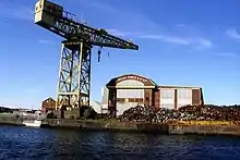
| |||
| 2 Broomhill Avenue And 1-3 (Odd Nos) Broomhill Terrace | 55°52′22″N 4°19′27″W | Category C(S) | 32288 | Upload Photo | |||
| 63, 65, 69, 71, 73, 77, 79, 81, 83, 85, 87, 89 St George's Road And 10, 14, 18, 20, 24 28 Woodlands Road | 55°52′04″N 4°16′17″W | Category B | 32249 | 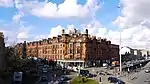
| |||
| Lynedoch Place/Park Circus Place; Park Church Tower | 55°52′07″N 4°16′37″W | Category B | 32223 | Upload Photo | |||
| 21-25 (Odd Nos) Glasgow Street | 55°52′29″N 4°17′02″W | Category B | 32193 | Upload Photo | |||
| Kelvingrove Park, Roberts Memorial | 55°52′13″N 4°16′55″W | Category A | 32211 | 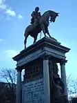
| |||
| Kelvin Way, Paired Gatepiers To Kelvin Way At University Avenue And Sauchiehall Street | 55°52′01″N 4°17′19″W | Category C(S) | 32214 | 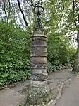
| |||
| 753 And 755 Westerhouse Road, St Benedict's Roman Catholic Church And Presbytery | 55°52′10″N 4°07′08″W | Category B | 32159 | 
| |||
| 10, 14-32 (Even Nos) Queen Mary Avenue, Speirs Place | 55°49′59″N 4°15′45″W | Category B | 32172 | 
| |||
| 118 And 126-136 (Even Nos) Stanley Street, Former Our Lady And St Margaret's Presbytery And Primary School (Roman Catholic) Including Gatepiers, Gates, Railings And Boundary Wall | 55°51′03″N 4°16′50″W | Category C(S) | 46279 | Upload Photo | |||
| 316 Caledonia Road, Rutherglen Road, Southern Necropolis Cemetery And Boundary Walls | 55°50′37″N 4°14′49″W | Category B | 47416 | 
| |||
| 197 Crookston Road, Ross Hall Park, Grotto, Rock Garden, Passage, Retaining Wall, Boat House And Ornamental Paths | 55°50′19″N 4°21′48″W | Category B | 48282 | Upload Photo | |||
| 39-45 (Odd Nos) Washington Street, Royal Scottish Pipe Band Association Headquarters And College | 55°51′29″N 4°16′06″W | Category C(S) | 48631 | Upload Photo | |||
| 5 And 7 Horselethill Road, Horselethill House With Conservatory | 55°52′43″N 4°17′49″W | Category C(S) | 48683 | Upload Photo | |||
| 36-40 Golspie Street & 16 Garmouth Street, Salvation Army Citadel | 55°51′47″N 4°19′04″W | Category B | 49789 | Upload Photo | |||
| 93 Saracen Street, Former Askit Laboratory And Manufactory Including Boundary Wall | 55°52′50″N 4°15′17″W | Category B | 49923 | Upload Photo | |||
| 243 Centre Street, Former Telephone Exchange | 55°51′04″N 4°15′44″W | Category B | 49932 | Upload Photo | |||
| 74 Victoria Crescent Road, Former Dowanside House And Former Notre Dame Training College Wing To East Including Gatepiers, Railings And Boundary Walls | 55°52′39″N 4°17′57″W | Category C(S) | 50027 | Upload Photo | |||
| 242 Castlemilk Road, King's Park Church Including Gates And Railings | 55°49′14″N 4°14′04″W | Category B | 50119 | 
| |||
| 30 Havelock Street, Dowanhill Primary School, Including Boundary Walls And Gatepiers | 55°52′27″N 4°17′55″W | Category C(S) | 50273 | Upload Photo | |||
| Partick Bridge Over River Kelvin | 55°52′11″N 4°17′39″W | Category B | 50583 | Upload Photo | |||
| Albert Drive, Edward Viii Pillar Box | 55°50′33″N 4°16′30″W | Category B | 50819 | Upload Photo | |||
| Cathedral Square, Police Box | 55°51′44″N 4°14′11″W | Category B | 51059 | 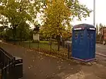
| |||
| 7 Broompark Circus, Broompark Day Nursery Including Boundary Walls And Gatepiers | 55°51′44″N 4°13′22″W | Category C(S) | 51444 | Upload Photo | |||
| 12 Washington Street, Former Washington Street Public School With Boundary Walls, Gatepiers, Steps And Railings | 55°51′32″N 4°16′09″W | Category C(S) | 45642 | Upload Photo | |||
| 176-178 (Even Nos) Bath Street | 55°51′53″N 4°15′42″W | Category C(S) | 44597 | Upload Photo | |||
| 52 Speirs Wharf, Wheatsheaf Building | 55°52′28″N 4°15′26″W | Category C(S) | 44112 | Upload Photo | |||
| 5 And 7 Wellington Street And 306-314 (Even Nos) Argyle Street | 55°51′32″N 4°15′41″W | Category C(S) | 43902 | Upload Photo | |||
| Great Western Road, Anniesland Station Bridge | 55°53′20″N 4°19′20″W | Category B | 43373 | 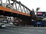
| |||
| 55 Crescent Road, Dunronald With Gate, Railings And Gatepiers | 55°53′13″N 4°21′26″W | Category B | 43115 | Upload Photo | |||
| 12 Dunterlie Avenue, Knightswood Congregational Church And Hall With Railings And Gates | 55°53′24″N 4°21′28″W | Category B | 43116 | Upload Photo | |||
| 215 Kinfauns Drive, St Laurence (Martyr) Roman Catholic Church And Presbytery With Boundary Wall, Gates, Gatepiers And Railings | 55°54′53″N 4°22′30″W | Category B | 43029 | Upload Photo | |||
| 29 Newlands Road, 8 Lubnaig Road, Carradale | 55°49′14″N 4°16′52″W | Category B | 33946 | Upload Photo | |||
| 14, 16 St Bride`S Road | 55°49′18″N 4°17′07″W | Category B | 33962 | Upload Photo | |||
| 223 Shawbridge Street, Pollokshaws Parish Church | 55°49′18″N 4°17′59″W | Category B | 33964 | 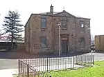
| |||
| 6 Onslow Drive, Day Nursery | 55°51′41″N 4°13′14″W | Category C(S) | 33903 | Upload Photo | |||
| 2 Auldhouse Court, Thornliebank Road | 55°48′59″N 4°18′14″W | Category B | 33913 | Upload Photo | |||
| Ellangowan Road And Haggs Road, Electricity Substation Including Gatepiers And Boundary Wall | 55°49′43″N 4°17′43″W | Category B | 33922 | Upload Photo | |||
| 351-355 (Odd Nos) Kilmarnock Road And Newlands Road, St Margaret's Episcopal Church And Halls, Including Gates And Railings | 55°49′18″N 4°17′11″W | Category B | 33926 | 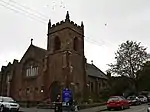
| |||
| 26 Langside Avenue And 1041-1043 (Odd Nos) Pollokshaws Road, Marlborough House Including Maxwells | 55°49′52″N 4°16′44″W | Category C(S) | 33928 | Upload Photo | |||
| Glasgow Green, Saltmarket Maclennan Arch | 55°51′12″N 4°14′45″W | Category B | 33841 | 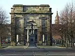
| |||
| 14 Monteith Row, Monteith Hotel | 55°51′12″N 4°14′15″W | Category B | 33854 | Upload Photo | |||
| 18 And 20 Castlefield Court | 55°53′03″N 4°10′00″W | Category B | 33866 | Upload Photo | |||
| Gartloch Road, Gartloch Hospital, West Lodge | 55°52′54″N 4°06′33″W | Category B | 33871 | 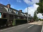
| |||
| Gartloch Road, Gartloch Hospital, New Nurses Home | 55°52′40″N 4°06′39″W | Category B | 33872 | Upload Photo | |||
| 1019-1041 (Odd Nos) Cathcart Road And 3 Stanmore Road | 55°49′39″N 4°15′32″W | Category C(S) | 33799 | 
| |||
| 1123 Cathcart Road, Hampden Drive, Mount Florida Parish Church Including Railings | 55°49′33″N 4°15′24″W | Category B | 33800 | Upload Photo | |||
| 2-26 (Even Nos) Dalmarnock Road And 1-11 (Odd Nos) Main Street Bridgeton, Bridgeton Cross Mansions | 55°50′54″N 4°13′34″W | Category C(S) | 33826 | Upload Photo | |||
| Glasgow Green, Boathouse Nearest Weir And Pipe Bridge | 55°51′07″N 4°14′38″W | Category B | 33834 | Upload Photo | |||
| 520 Bilsland Drive, Ruchill Hospital, Water Tower | 55°53′13″N 4°15′57″W | Category A | 33750 | Upload Photo | |||
| 1-6 (Inclusive Nos) Doune Quadrant | 55°52′43″N 4°16′55″W | Category C(S) | 33760 | Upload Photo | |||
| 251-261 (Odd Nos) Garrioch Road | 55°52′57″N 4°17′18″W | Category B | 33761 | Upload Photo | |||
| 14 Kelvin Drive And Gatepiers | 55°52′50″N 4°17′15″W | Category B | 33769 | Upload Photo | |||
| 9 Kelvinside Gardens, St Charles Rc Church | 55°52′45″N 4°16′37″W | Category B | 33771 | Upload Photo | |||
| 2 Kelvinside Terrace West And 301 Wilton Street With Retaining Walls | 55°52′46″N 4°17′02″W | Category B | 33773 | Upload Photo | |||
| 405, 407 Cumberland Street, St Francis Church And Presbytery | 55°50′47″N 4°14′45″W | Category A | 33690 | Upload Photo | |||
| 119 Carmunnock Road, Cathcart Old Parish Church Including Session House, Gates, Gatepiers And Boundary Walls | 55°49′05″N 4°15′15″W | Category B | 33707 | 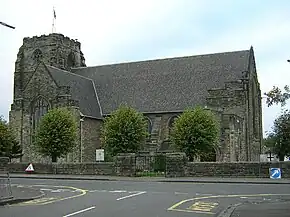
| |||
| 1035 Balmore Road, Lambhill Cemetery, Entrance Arch, Railings And Gates | 55°54′09″N 4°16′10″W | Category B | 33728 | Upload Photo | |||
| 2064 Maryhill Road | 55°53′58″N 4°18′05″W | Category B | 33733 | Upload Photo | |||
| London Road, Belvidere Hospital, Nurses' Home/Administration Block | 55°50′42″N 4°12′02″W | Category B | 33638 | Upload Photo | |||
| 1147 And 1167 London Road, London Road School Including Lodge, Boundary Walls And Gatepiers | 55°50′54″N 4°12′24″W | Category B | 33639 | Upload Photo | |||
| 1169 Shettleston Road, Portland Arms Public House | 55°51′06″N 4°09′55″W | Category B | 33645 | Upload Photo | |||
| 591 Tollcross Road, Tollcross House, Tollcross Park | 55°50′47″N 4°10′47″W | Category A | 33648 | 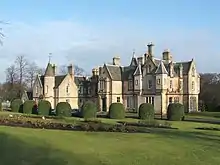
| |||
| 591 Tollcross Road, Tollcross House Conservatory, Tollcross Park | 55°50′51″N 4°10′45″W | Category B | 33650 | Upload Photo | |||
| 155 Carmyle Avenue, Carmyle Church And Gatepiers, Boundary Walls And Railings | 55°49′51″N 4°09′29″W | Category B | 33661 | .jpg.webp)
| |||
| 315 And 315A Hamilton Road, Boghall Steading | 55°50′26″N 4°07′28″W | Category C(S) | 33669 | Upload Photo | |||
| 102-106 (Even Nos) Main Street, Church Street, Baillieston | 55°51′01″N 4°06′37″W | Category C(S) | 33673 | Upload Photo | |||
| 15 Swinton Road, St Bridget's Roman Catholic Church And Presbytery, Boundary Walls, Gates And Railings | 55°51′09″N 4°06′36″W | Category B | 33679 | Upload Photo | |||
| 161 Crookston Road, Former Stable Block To Ross Hall | 55°50′28″N 4°21′50″W | Category C(S) | 33590 | Upload Photo | |||
| 510 Crookston Road, Leverndale Hospital, Gate Lodge | 55°50′06″N 4°21′51″W | Category C(S) | 33594 | Upload Photo | |||
| 21 Lochmaben Road, Former Crookston Station And Stationmaster's Cottage | 55°50′33″N 4°21′52″W | Category B | 33600 | 
| |||
| 7 Keppochill Road, Keppochhill Court, Blocks A And B, Former Springburn Fire Station With Elevation To Springburn Road | 55°52′47″N 4°14′04″W | Category B | 33615 | Upload Photo | |||
| 2 Speirs Wharf, Canal House | 55°52′18″N 4°15′27″W | Category B | 33618 | Upload Photo | |||
| 247-255 (Odd Nos) Springburn Way (Formerly 563-567 (Odd Nos) Springburn Road), And 30 Hillkirk Street Lane, Trustee Savings Bank Building | 55°53′00″N 4°13′46″W | Category B | 33625 | Upload Photo | |||
| 225 Scotland Street, Scotland Street School, With Janitor's House And Railings | 55°50′58″N 4°16′25″W | Category A | 33534 | 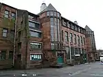
| |||
| 2-6 Scotland Street (Even Nos), 220-228 West Street (Even Nos) And 65-75 Paterson Street (Odd Nos) | 55°51′00″N 4°16′01″W | Category B | 33535 | Upload Photo | |||
| 3 Sydenham Road, Including Mews Cottage | 55°52′42″N 4°18′09″W | Category B | 33544 | Upload Photo | |||
| 6 Rowan Road Craigie Hall, Dumbreck | 55°50′49″N 4°18′32″W | Category A | 33583 | .jpg.webp)
| |||
| 50 St Andrew's Drive, Glenafton Nursing Home, Including Boundary Walls And Gatepiers | 55°50′43″N 4°17′16″W | Category B | 33466 | Upload Photo | |||
| 620 Shields Road, Nithsdale Lodge, Former Pollokshields West Church Including Boundary Wall And Gatepiers | 55°50′26″N 4°16′40″W | Category B | 33482 | 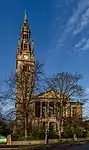
| |||
| 99 Springkell Avenue, Including Boundary Walls And Gatepiers | 55°50′21″N 4°17′53″W | Category B | 33483 | Upload Photo | |||
| 129 Abbotsford Place And Pollokshaws Road, School And Janitor's House | 55°50′47″N 4°15′32″W | Category B | 33490 | 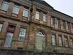
| |||
| 339 Eglinton Street And Devon Street, Former Eglinton Congregational Church | 55°50′47″N 4°15′39″W | Category B | 33509 | Upload Photo | |||
| 63 Fotheringay Road, United Reformed Church, Former Pollokshields Congregational Church And Hall | 55°50′14″N 4°17′01″W | Category C(S) | 33406 | Upload Photo | |||
| 30 Leslie Street And Kenmure Street, Pollokshields District Library | 55°50′28″N 4°16′22″W | Category B | 33419 | 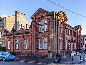
| |||
| 8 Matilda Road, Including Boundary Walls And Gatepiers | 55°50′40″N 4°17′05″W | Category B | 33422 | Upload Photo | |||
| 37, 37A Newark Drive, Including Boundary Walls And Gatepiers | 55°50′24″N 4°17′00″W | Category B | 33431 | Upload Photo | |||
| 39 Newark Drive, Including Boundary Walls And Gatepiers | 55°50′25″N 4°17′02″W | Category B | 33432 | Upload Photo | |||
| 202 Nithsdale Road, Castlehill, Including Boundary Walls And Gatepiers | 55°50′32″N 4°17′13″W | Category A | 33451 | Upload Photo | |||
| 514 And 516 Pollokshaws Road And 1 Albert Drive, St Ninian's Episcopal Church Including Hall | 55°50′27″N 4°16′00″W | Category B | 33454 | 
| |||
| 55 St Andrews Drive Including Gatepiers, Boundary Walls And Gates | 55°50′42″N 4°17′12″W | Category B | 33461 | Upload Photo | |||
| Kittoch Bridge, B759 Over Kittoch Water | 55°47′06″N 4°15′03″W | Category C(S) | 33332 | Upload Photo | |||
| Linn Park, Iron Bridge | 55°48′20″N 4°15′56″W | Category B | 33333 | 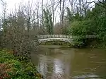
| |||
| 18 Clydebrae Street, Govan Graving Docks | 55°51′39″N 4°18′03″W | Category A | 33336 | .jpg.webp)
| |||
| 577-581 Govan Road, Former Govan Press Buildings | 55°51′37″N 4°18′13″W | Category B | 33341 | Upload Photo | |||
| Near 801 Govan Road, Junction With Burleigh Street, Sir William Pearce, Statue | 55°51′48″N 4°18′46″W | Category B | 33343 | 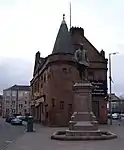
| |||
| 816, 818 Govan Road, 1, 3 Water Row, Former British Linen Bank, And Flats | 55°51′48″N 4°18′42″W | Category A | 33351 | Upload Photo | |||
| 100-132 (Even Nos) Albert Drive And Darnley Street | 55°50′30″N 4°16′11″W | Category B | 33375 | Upload Photo | |||
| 330 And 330A Albert Drive, Including Boundary Walls And Gatepiers | 55°50′39″N 4°17′06″W | Category B | 33380 | Upload Photo | |||
| 110 West George Street | 55°51′45″N 4°15′21″W | Category B | 33237 | 
| |||
| 144, 146 West George Street, Cornhill House | 55°51′46″N 4°15′26″W | Category A | 33241 | Upload Photo | |||
| 110-126 (Even Nos) West Nile Street And 17, 19 Bath Street | 55°51′48″N 4°15′15″W | Category C(S) | 33255 | Upload Photo | |||
| 79 West Regent Street And 183-191 (Odd Nos) Hope Street | 55°51′47″N 4°15′29″W | Category B | 33258 | Upload Photo | |||
| 91, 93 West Regent Street | 55°51′47″N 4°15′31″W | Category C(S) | 33261 | Upload Photo | |||
| 172-186 (Even Nos) West Regent Street | 55°51′50″N 4°15′42″W | Category B | 33279 | 
| |||
| 74 York Street And 55-61 (Odd Nos) Robertson Lane | 55°51′30″N 4°15′44″W | Category B | 33284 | Upload Photo | |||
| 166 Broomfield Road, Immaculate Heart Of Mary, Rc Church | 55°53′14″N 4°13′29″W | Category B | 33294 | Upload Photo | |||
| Elder Park, Cottage | 55°51′49″N 4°19′37″W | Category B | 33302 | Upload Photo | |||
| Elder Park, Statue Of John Elder | 55°51′46″N 4°19′19″W | Category B | 33305 | 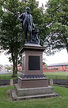
| |||
| 1345 Govan Road, Southern General Hospital | 55°51′47″N 4°20′15″W | Category B | 33307 | 
| |||
| 336-356 (Even Nos) Sauchiehall Street And 1 Scott Street | 55°51′57″N 4°15′54″W | Category A | 33193 | 
| |||
| 396-450A (Even Nos) Sauchiehall Street, And 2 Garnet Street | 55°51′58″N 4°16′00″W | Category B | 33194 | _SAUCHIEHALL_STREET%252C_AND_2_GARNET_STREET%252C_Glasgow_LB33194.jpg.webp) |
Key
The scheme for classifying buildings in Scotland is:
- Category A: "buildings of national or international importance, either architectural or historic; or fine, little-altered examples of some particular period, style or building type."[1]
- Category B: "buildings of regional or more than local importance; or major examples of some particular period, style or building type, which may have been altered."[1]
- Category C: "buildings of local importance; lesser examples of any period, style, or building type, as originally constructed or moderately altered; and simple traditional buildings which group well with other listed buildings."[1]
In March 2016 there were 47,288 listed buildings in Scotland. Of these, 8% were Category A, and 50% were Category B, with the remaining 42% being Category C.[2]
See also
Notes
- Sometimes known as OSGB36, the grid reference (where provided) is based on the British national grid reference system used by the Ordnance Survey.
• "Guide to National Grid". Ordnance Survey. Retrieved 12 December 2007.
• "Get-a-map". Ordnance Survey. Retrieved 17 December 2007. - Historic Environment Scotland assign a unique alphanumeric identifier to each designated site in Scotland, for listed buildings this always begins with "LB", for example "LB12345".
References
- All entries, addresses and coordinates are based on data from Historic Scotland. This data falls under the Open Government Licence
- "What is Listing?". Historic Environment Scotland. Retrieved 29 May 2018.
- Scotland's Historic Environment Audit 2016 (PDF). Historic Environment Scotland and the Built Environment Forum Scotland. pp. 15–16. Retrieved 29 May 2018.
This article is issued from Wikipedia. The text is licensed under Creative Commons - Attribution - Sharealike. Additional terms may apply for the media files.