List of listed buildings in Inverness and Bona
This is a list of listed buildings in the parish of Inverness and Bona (outwith the burgh of Inverness) in Highland, Scotland. For listed buildings within Inverness burgh, see List of listed buildings in Inverness.
List
| Name | Location | Date Listed | Grid Ref. [note 1] | Geo-coordinates | Notes | LB Number [note 2] | Image |
|---|---|---|---|---|---|---|---|
| Culloden House Dovecote | 57°29′16″N 4°08′10″W | Category B | 10953 | 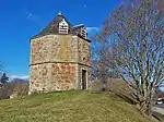
| |||
| Caledonian Canal, Dochgarroch Locks, Lock Keeper's Cottage And Barn | 57°25′59″N 4°18′12″W | Category C(S) | 8033 | .jpg.webp)
| |||
| Culloden, Loch Lann (Former Culloden House Kennels) | 57°29′11″N 4°08′00″W | Category B | 8040 |  Upload Photo | |||
| Culloden Ice House | 57°29′26″N 4°07′46″W | Category C(S) | 8041 | 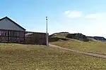
| |||
| Drumossie Hotel | 57°27′27″N 4°09′35″W | Category B | 8046 | 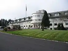
| |||
| Dunain House | 57°27′03″N 4°17′20″W | Category C | 8047 | 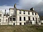
| |||
| Leys Castle, The Grange | 57°26′07″N 4°12′05″W | Category B | 8055 | Upload Photo | |||
| Ness Castle And Glass Houses | 57°26′38″N 4°14′56″W | Category B | 8056 | Upload Photo | |||
| Culloden House Walled Garden | 57°29′31″N 4°08′16″W | Category B | 10952 | Upload Photo | |||
| Bona Church Of Scotland And Manse | 57°24′28″N 4°20′24″W | Category B | 8032 | Upload Photo | |||
| Cradlehall House | 57°28′27″N 4°09′52″W | Category B | 8036 | Upload Photo | |||
| Drumdevan House | 57°26′31″N 4°14′31″W | Category C(S) | 8045 | Upload Photo | |||
| Dochfour House, Gardener's Cottage And Walled Garden | 57°25′08″N 4°19′43″W | Category C(S) | 8065 | Upload Photo | |||
| Dochfour House | 57°25′18″N 4°19′31″W | Category A | 8028 | 
| |||
| Craig Dunain Hospital | 57°27′50″N 4°16′30″W | Category B | 8037 | ||||
| Culloden House, Gate Piers And Gardeners' Bothy | 57°29′26″N 4°08′07″W | Category A | 8039 | 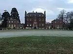
| |||
| Stratton Lodge Hotel | 57°29′22″N 4°09′07″W | Category B | 8060 | .jpg.webp)
| |||
| Abriachan, Balbeg Mill | 57°22′57″N 4°23′30″W | Category C(S) | 8029 | 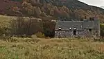
| |||
| Bona Free Church and Burial Ground, Dochfour | 57°24′57″N 4°19′43″W | Category C(S) | 8043 | 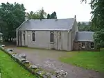
| |||
| Dochfour House Obelisk And Private Burial Ground | 57°25′43″N 4°18′56″W | Category B | 8063 | .jpg.webp)
| |||
| Dochfour, Church Cottage, Kirkton | 57°24′59″N 4°19′42″W | Category C(S) | 8066 | Upload Photo | |||
| Allanfearn Farmhouse | 57°29′58″N 4°08′39″W | Category B | 8030 | Upload Photo | |||
| Dunain Park Hotel | 57°27′13″N 4°16′29″W | Category C(S) | 8048 | .jpg.webp)
| |||
| Inshes House | 57°27′54″N 4°10′38″W | Category B | 8049 | Upload Photo | |||
| Killianan Burial Ground | 57°22′48″N 4°22′39″W | Category C(S) | 8052 | Upload Photo | |||
| Raigmore Tower | 57°28′14″N 4°08′46″W | Category B | 8057 | Upload Photo | |||
| AA Sentry Box (No 631), Brachla | 57°21′49″N 4°23′36″W | Category B | 49223 | 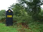
| |||
| Culloden House Stables and Yard Wall | 57°29′18″N 4°08′09″W | Category A | 10954 | 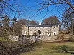
| |||
| Caledonian Canal, Lochend, Bona Lighthouse | 57°24′29″N 4°19′43″W | Category B | 8034 | 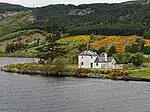
| |||
| Culloden Moor, Kings Stable Cottage | 57°28′34″N 4°06′50″W | Category B | 8042 | 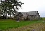
| |||
| Leys Castle Lodge | 57°26′19″N 4°12′15″W | Category C(S) | 8054 | Upload Photo | |||
| Seafield Of Raigmore | 57°29′08″N 4°10′31″W | Category B | 8058 | Upload Photo | |||
| Dochgarroch House | 57°26′14″N 4°18′20″W | Category B | 8067 | Upload Photo | |||
| Bogbain Farmhouse | 57°26′54″N 4°09′14″W | Category C(S) | 8031 | Upload Photo | |||
| Inshes House, Tower House In Grounds | 57°27′53″N 4°10′38″W | Category A | 8050 | Upload Photo | |||
| Inshes, Helen's Lodge | 57°27′48″N 4°10′49″W | Category C(S) | 8051 | Upload Photo | |||
| Leys Castle And Garden Terraces | 57°26′24″N 4°12′02″W | Category A | 8053 | Upload Photo | |||
| Dochfour House, East Drive Entrance Gate Piers And Gates, Gate Lodge And Policy Walls Fronting A82 Road | 57°25′41″N 4°18′36″W | Category B | 8061 | Upload Photo | |||
| Dochfour House, Farm Steading | 57°25′26″N 4°19′27″W | Category B | 8062 | 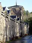
| |||
| Castlehill House | 57°28′11″N 4°10′29″W | Category B | 8035 | 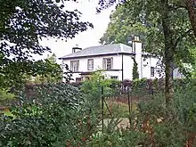
| |||
| Culduthel House (Part Of Culduthel Hospital) | 57°27′03″N 4°13′39″W | Category B | 8038 | 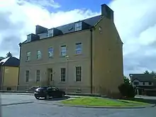
| |||
| Dochgarroch, Dunain Lodge (West Gate Lodge To Docharroch House) And Gate Piers | 57°26′38″N 4°17′48″W | Category B | 8044 | Upload Photo | |||
| Stoneyfield House | 57°28′55″N 4°11′09″W | Category B | 8059 | 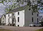
| |||
| Dochfour House, Dairy | 57°25′27″N 4°19′22″W | Category B | 8064 | Upload Photo |
Key
The scheme for classifying buildings in Scotland is:
- Category A: "buildings of national or international importance, either architectural or historic; or fine, little-altered examples of some particular period, style or building type."[1]
- Category B: "buildings of regional or more than local importance; or major examples of some particular period, style or building type, which may have been altered."[1]
- Category C: "buildings of local importance; lesser examples of any period, style, or building type, as originally constructed or moderately altered; and simple traditional buildings which group well with other listed buildings."[1]
In March 2016 there were 47,288 listed buildings in Scotland. Of these, 8% were Category A, and 50% were Category B, with the remaining 42% being Category C.[2]
Notes
- Sometimes known as OSGB36, the grid reference (where provided) is based on the British national grid reference system used by the Ordnance Survey.
• "Guide to National Grid". Ordnance Survey. Retrieved 12 December 2007.
• "Get-a-map". Ordnance Survey. Retrieved 17 December 2007. - Historic Environment Scotland assign a unique alphanumeric identifier to each designated site in Scotland, for listed buildings this always begins with "LB", for example "LB12345".
References
- All entries, addresses and coordinates are based on data from Historic Scotland. This data falls under the Open Government Licence
- "What is Listing?". Historic Environment Scotland. Retrieved 29 May 2018.
- Scotland's Historic Environment Audit 2016 (PDF). Historic Environment Scotland and the Built Environment Forum Scotland. pp. 15–16. Retrieved 29 May 2018.
This article is issued from Wikipedia. The text is licensed under Creative Commons - Attribution - Sharealike. Additional terms may apply for the media files.