List of listed buildings in Kilmorack
This is a list of listed buildings in the parish of Kilmorack in Highland, Scotland. This contains the town of Beauly, as well as an area extending to the west along the north side of the River Beauly, including Struy, Cannich, and Glen Affric.
List
| Name | Location | Date Listed | Grid Ref. [note 1] | Geo-coordinates | Notes | LB Number [note 2] | Image |
|---|---|---|---|---|---|---|---|
| Hawthorn and 25 Ferry Road | Beauly | 57°28′59″N 4°27′30″W | Category C(S) | 7107 |  Upload Photo | ||
| 29 Ferry Road (Cherry Tree Cottage) | Beauly | 57°28′58″N 4°27′29″W | Category C(S) | 7109 | Upload Photo | ||
| Lovat Arms Hotel | Beauly | 57°28′59″N 4°27′40″W | Category B | 7130 | .jpg.webp)
| ||
| 52, 54 High Street | Beauly | 57°29′04″N 4°27′34″W | Category B | 7133 | Upload Photo | ||
| 1 Priory Court, The Square | Beauly | 57°29′03″N 4°27′31″W | Category C(S) | 7134 | Upload Photo | ||
| Matheson's Bakery, The Square | Beauly | 57°29′00″N 4°27′34″W | Category C(S) | 7139 | Upload Photo | ||
| St Mary's Roman Catholic Church, Burial Ground and Presbytery | Beauly | 57°29′10″N 4°27′28″W | Category B | 7111 | 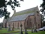
| ||
| Fasnakyle Power Station, Glen Affric Hydro Electric Scheme | By Cannich | 57°19′34″N 4°47′39″W | Category A | 7118 | 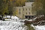
| ||
| Old Burial Ground | Kilmorack | 57°27′49″N 4°30′48″W | Category C(S) | 7123 | Upload Photo | ||
| Gate Lodge, Aigas House | Aigas | 57°26′20″N 4°33′53″W | Category C(S) | 7126 | 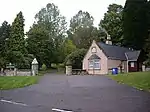
| ||
| 4-12(inclusive nos) Priory Court, The Square | Beauly | 57°29′02″N 4°27′31″W | Category C(S) | 7136 | Upload Photo | ||
| Knockfin House | By Tomich | 57°18′03″N 4°49′26″W | Category C(S) | 7101 | Upload Photo | ||
| Ardmor House, The Square | Beauly | 57°29′00″N 4°27′34″W | Category C(S) | 7104 | Upload Photo | ||
| 27 Ferry Road (Roselea) | Beauly | 57°28′59″N 4°27′29″W | Category C(S) | 7108 | Upload Photo | ||
| Netherdale | Beauly | 57°28′52″N 4°27′52″W | Category C(S) | 7110 | Upload Photo | ||
| Well House Farm | By Beauly | 57°29′29″N 4°28′02″W | Category B | 7112 | Upload Photo | ||
| Mill | Cannich | 57°20′46″N 4°45′22″W | Category B | 7116 | Upload Photo | ||
| Glen Affric Lodge | Glen Affric | 57°15′39″N 5°00′45″W | Category A | 7121 | 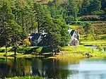
| ||
| Old Manse and Steading | Kilmorack | 57°27′53″N 4°30′52″W | Category B | 7124 | Upload Photo | ||
| Monar Dam And Deanie Tunnel Intake Tower, Glen Affric Hydro Electric Scheme | Glen Strathfarrar | 57°24′32″N 4°59′35″W | Category B | 51702 | .jpg.webp)
| ||
| Comar | Cannich | 57°20′30″N 4°46′18″W | Category C(S) | 7113 | Upload Photo | ||
| Cannich Church Of Scotland | Cannich | 57°20′47″N 4°46′01″W | Category C(S) | 7114 | Upload Photo | ||
| Marydale Roman Catholic Church, Presbytery and Former School | Cannich | 57°20′45″N 4°45′30″W | Category B | 7115 | Upload Photo | ||
| Fasnakyle Bridge Over River Glass | By Cannich | 57°19′27″N 4°47′30″W | Category B | 7119 | 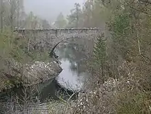
| ||
| Campbell and Co, High Street | Beauly | 57°28′58″N 4°27′37″W | Category C(S) | 7131 | 
| ||
| 2 and 3 Priory Court, The Square | Beauly | 57°29′03″N 4°27′31″W | Category C(S) | 7135 | Upload Photo | ||
| Market Cross, The Square | Beauly | 57°29′03″N 4°27′33″W | Category B | 49635 | 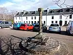
| ||
| Old Parish Church and Burial Ground | Kilmorack | 57°27′51″N 4°30′42″W | Category B | 7122 | 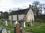
| ||
| Beauly Priory | Beauly | 57°29′05″N 4°27′28″W | Category A | 7129 | 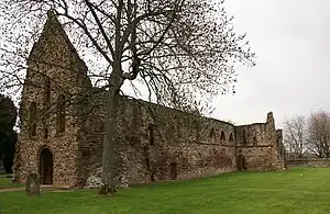
| ||
| Former School and Schoolhouse | Struy | 57°25′05″N 4°40′09″W | Category B | 7103 | 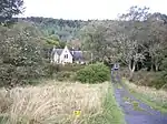
| ||
| Culloch House, The Square | Beauly | 57°29′00″N 4°27′35″W | Category C(S) | 7105 | Upload Photo | ||
| Glassburn | Strathglass | 57°22′17″N 4°42′51″W | Category B | 7120 | Upload Photo | ||
| Former Free Church and Enclosing Walls | Wester Balblair | 57°28′15″N 4°29′18″W | Category C(S) | 7128 | .jpg.webp)
| ||
| Commercial Hotel, Commercial Street | Beauly | 57°29′02″N 4°27′32″W | Category C(S) | 7137 | Upload Photo | ||
| Smithy Cottage | Crask of Aigas | 57°26′41″N 4°33′19″W | Category C(S) | 49020 | Upload Photo | ||
| Eileanaigas House | Eilean Aigas | 57°26′28″N 4°33′09″W | Category B | 7117 | .jpg.webp)
| ||
| Druim Cottage | Crask of Aigas | 57°26′44″N 4°33′18″W | Category C(S) | 7127 | Upload Photo | ||
| Mullardoch Dam, Glen Affric Hydro Electric Scheme | Glen Cannich | 57°20′17″N 4°57′18″W | Category B | 51703 | .jpg.webp)
| ||
| Bank Of Scotland | Beauly | 57°29′01″N 4°27′38″W | Category B | 7106 | 
| ||
| Aigas House (now Aigas Field Centre) | Aigas | 57°26′14″N 4°34′03″W | Category B | 7125 | 
| ||
| 3, 4 High Street | Beauly | 57°29′01″N 4°27′36″W | Category C(S) | 7132 | Upload Photo | ||
| Beaufort House, The Square | Beauly | 57°29′01″N 4°27′33″W | Category C(S) | 7138 | Upload Photo | ||
| Corf House | By Lovat Bridge | 57°28′11″N 4°28′36″W | Category B | 7102 | Upload Photo |
Key
The scheme for classifying buildings in Scotland is:
- Category A: "buildings of national or international importance, either architectural or historic; or fine, little-altered examples of some particular period, style or building type."[1]
- Category B: "buildings of regional or more than local importance; or major examples of some particular period, style or building type, which may have been altered."[1]
- Category C: "buildings of local importance; lesser examples of any period, style, or building type, as originally constructed or moderately altered; and simple traditional buildings which group well with other listed buildings."[1]
In March 2016 there were 47,288 listed buildings in Scotland. Of these, 8% were Category A, and 50% were Category B, with the remaining 42% being Category C.[2]
See also
Notes
- Sometimes known as OSGB36, the grid reference (where provided) is based on the British national grid reference system used by the Ordnance Survey.
• "Guide to National Grid". Ordnance Survey. Retrieved 12 December 2007.
• "Get-a-map". Ordnance Survey. Retrieved 17 December 2007. - Historic Environment Scotland assign a unique alphanumeric identifier to each designated site in Scotland, for listed buildings this always begins with "LB", for example "LB12345".
References
- All entries, addresses and coordinates are based on data from Historic Scotland. This data falls under the Open Government Licence
- "What is Listing?". Historic Environment Scotland. Retrieved 29 May 2018.
- Scotland's Historic Environment Audit 2016 (PDF). Historic Environment Scotland and the Built Environment Forum Scotland. pp. 15–16. Retrieved 29 May 2018.
This article is issued from Wikipedia. The text is licensed under Creative Commons - Attribution - Sharealike. Additional terms may apply for the media files.