List of listed buildings in Larbert, Falkirk
List
| Name | Location | Date Listed | Grid Ref. [note 1] | Geo-coordinates | Notes | LB Number [note 2] | Image |
|---|---|---|---|---|---|---|---|
| Kinnaird House | 56°02′38″N 3°47′30″W | Category B | 10498 |  Upload Photo | |||
| Kinnaird House Walled Gardens | 56°02′35″N 3°47′37″W | Category B | 10499 | Upload Photo | |||
| Kinnaird House Stable Group | 56°02′39″N 3°47′31″W | Category C(S) | 10500 | Upload Photo | |||
| Old Parish Church Churchyard And Monument To James Bruce Of Kinnaird And Mary Dundas | 56°01′08″N 3°50′17″W | Category A | 10496 | 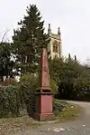
| |||
| Larbert Old Church (Parish Church) | 56°01′09″N 3°50′11″W | Category B | 10515 | .jpg.webp)
| |||
| Larbert Viaduct | 56°00′59″N 3°49′55″W | Category B | 10517 | .jpg.webp)
| |||
| Royal Scottish National Hospital, Lodge | 56°01′51″N 3°50′00″W | Category C(S) | 47720 | 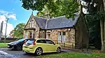
| |||
| Former Railway Bridge Across River Carron Carron Iron Works | 56°01′15″N 3°47′52″W | Category B | 13306 | 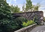
| |||
| Larbert House | 56°01′20″N 3°50′47″W | Category B | 10495 | Upload Photo | |||
| Kersebrock Farmhouse | 56°02′45″N 3°49′10″W | Category C(S) | 10497 | Upload Photo | |||
| Old Manse | 56°01′10″N 3°50′16″W | Category B | 10516 | Upload Photo | |||
| Weir Carron Iron Works | 56°01′14″N 3°47′59″W | Category B | 13305 | 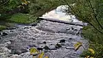
| |||
| Stenhousemuir Off Main Street, Carron Grange House | 56°01′14″N 3°48′30″W | Category B | 13347 | 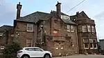
| |||
| Old Bridge Larbert | 56°00′58″N 3°49′52″W | Category C(S) | 10518 | Upload Photo | |||
| The Grahamston Cast-Iron Gate | 56°01′15″N 3°47′59″W | Category B | 31230 | 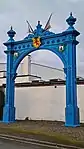
| |||
| Larbert Village Carronvale Road, Woodcroft | 56°01′07″N 3°49′28″W | Category B | 13348 | Upload Photo | |||
| Main Street, Dobbie Hall | 56°01′29″N 3°49′29″W | Category B | 10502 | 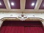
| |||
| Royal Scottish National Hospital, Principal Block (Private House) With Boundary Walls And Gatepiers | 56°01′55″N 3°50′00″W | NOW DEMOLISHED | 10481 | 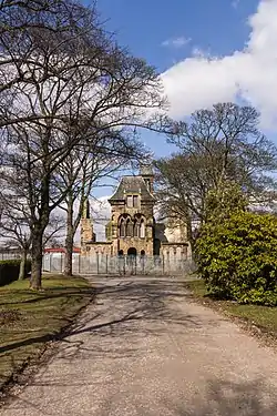
| |||
| Carronvale Road, 'Carronvale' (Boy's Brigade Hq) | 56°01′02″N 3°49′08″W | Category A | 10487 | Upload Photo | |||
| Royal Scottish National Hospital, Skye Building | 56°01′57″N 3°49′58″W | NOW DEMOLISHED | 48082 | Upload Photo | |||
| Larbert East Church And Hall King Street, Stenhousemuir | 56°01′34″N 3°48′51″W | Category B | 10488 | 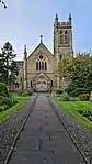
| |||
| Stenhousemuir, Church Street, Parish Church Of Stenhouse And Carron, Former Maclaren Memorial Church, Church Of Scotland | 56°01′38″N 3°48′19″W | Category A | 10503 | Upload Photo | |||
| Carron Company, Clock Tower Remnant Of Former Office Block | 56°01′21″N 3°47′43″W | Category C(S) | 10504 | 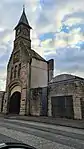 |
Key
The scheme for classifying buildings in Scotland is:
- Category A: "buildings of national or international importance, either architectural or historic; or fine, little-altered examples of some particular period, style or building type."[1]
- Category B: "buildings of regional or more than local importance; or major examples of some particular period, style or building type, which may have been altered."[1]
- Category C: "buildings of local importance; lesser examples of any period, style, or building type, as originally constructed or moderately altered; and simple traditional buildings which group well with other listed buildings."[1]
In March 2016 there were 47,288 listed buildings in Scotland. Of these, 8% were Category A, and 50% were Category B, with the remaining 42% being Category C.[2]
Notes
- Sometimes known as OSGB36, the grid reference (where provided) is based on the British national grid reference system used by the Ordnance Survey.
• "Guide to National Grid". Ordnance Survey. Retrieved 12 December 2007.
• "Get-a-map". Ordnance Survey. Retrieved 17 December 2007. - Historic Environment Scotland assign a unique alphanumeric identifier to each designated site in Scotland, for listed buildings this always begins with "LB", for example "LB12345".
References
- All entries, addresses and coordinates are based on data from Historic Scotland. This data falls under the Open Government Licence
- "What is Listing?". Historic Environment Scotland. Retrieved 29 May 2018.
- Scotland's Historic Environment Audit 2016 (PDF). Historic Environment Scotland and the Built Environment Forum Scotland. pp. 15–16. Retrieved 29 May 2018.
This article is issued from Wikipedia. The text is licensed under Creative Commons - Attribution - Sharealike. Additional terms may apply for the media files.