List of listed buildings in Largs, North Ayrshire
List
| Name | Location | Date Listed | Grid Ref. [note 1] | Geo-coordinates | Notes | LB Number [note 2] | Image |
|---|---|---|---|---|---|---|---|
| Halkshill House, Summer House (To West) | 55°47′38″N 4°51′19″W | Category B | 37173 |  Upload Photo | |||
| 4 John Street, Curling Hall Lodge | 55°47′18″N 4°51′56″W | Category B | 37175 | Upload Photo | |||
| 2 May Street Sherwood Hotel | 55°47′12″N 4°51′45″W | Category B | 37189 | Upload Photo | |||
| 67 Nelson Street | 55°47′47″N 4°51′54″W | Category C(S) | 37191 | Upload Photo | |||
| 28 Nelson Street Rondelle | 55°47′47″N 4°52′01″W | Category B | 37195 | Upload Photo | |||
| Skelmorlie Aisle And Cemetery Wall And Gate Piers | 55°47′41″N 4°52′07″W | Category A | 37198 | 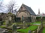
| |||
| Knock Castle West Lodge And Gatepiers | 55°49′25″N 4°53′18″W | Category B | 7273 | Upload Photo | |||
| Quarter House | 55°49′04″N 4°53′01″W | Category C(S) | 7279 | Upload Photo | |||
| Skelmorlie Measured Mile Marker Poles | 55°52′02″N 4°53′28″W | Category B | 7286 | Upload Photo | |||
| Skelmorlie Village 5 Montgomery Terrace Glendower House And Gatepiers To East And To West | 55°52′14″N 4°53′17″W | Category B | 7289 | Upload Photo | |||
| Fairlie Village Fairlie Parish Church Hall (Former Free Church) | 55°45′26″N 4°51′16″W | Category C(S) | 7291 | Upload Photo | |||
| Fairlie Village Fairlie School And Gatepiers | 55°45′27″N 4°51′13″W | Category B | 7292 | Upload Photo | |||
| Kelburn Monument To John, 3Rd Earl Of Glasgow | 55°46′15″N 4°50′27″W | Category A | 7295 | Upload Photo | |||
| Kelburn Former Stables And Cottages (Visitor Centre) | 55°46′09″N 4°50′43″W | Category B | 7296 | Upload Photo | |||
| Kelburn Cottages And Former Cartshed To North West Of Mansion House | 55°46′17″N 4°50′46″W | Category B | 7297 | Upload Photo | |||
| Kelburn Sundial To West Of House | 55°46′15″N 4°50′39″W | Category A | 7298 | Upload Photo | |||
| Knock Castle North Lodge And Gatepiers | 55°49′43″N 4°52′59″W | Category C(S) | 7309 | Upload Photo | |||
| Fairlie Village 8 Burnfoot Road Burnside | 55°45′09″N 4°51′16″W | Category B | 7314 | Upload Photo | |||
| Skelmorlie, 7-9 Eglinton Terrace, St Margaret's With Boundary Wall And Garden Steps | 55°51′46″N 4°53′12″W | Category C(S) | 50038 | Upload Photo | |||
| Aubery Crescent St Columba's Episcopal Church | 55°48′10″N 4°52′20″W | Category B | 37148 | Upload Photo | |||
| Bath Street, St John's Church | 55°47′35″N 4°52′14″W | Category B | 37153 | Upload Photo | |||
| Broomfield Place Elderslie Hotel (Building To North; Formerly Priory Lodge) | 55°47′19″N 4°51′57″W | Category B | 37161 | Upload Photo | |||
| 124 Greenock Road St Columba's College (Formerly Northfield) | 55°48′28″N 4°52′38″W | Category B | 37168 | Upload Photo | |||
| Greenock Road/ 1-9 (Odd Nos) Nelson Street, Nardini Lounge, Cafe And Restaurant | 55°47′49″N 4°52′08″W | Category B | 37170 | 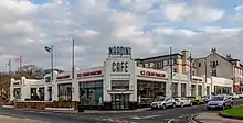
| |||
| Hailie House | 55°47′11″N 4°51′27″W | Category C(S) | 37171 | Upload Photo | |||
| 21 Main Street | 55°47′40″N 4°52′09″W | Category C(S) | 37180 | Upload Photo | |||
| 23 Main Street | 55°47′40″N 4°52′08″W | Category C(S) | 37181 | Upload Photo | |||
| Makerston Place, Public Fountain | 55°47′27″N 4°52′11″W | Category C(S) | 37188 | Upload Photo | |||
| Union Street Dunn Memorial Hall | 55°47′35″N 4°52′13″W | Category C(S) | 37196 | Upload Photo | |||
| Skelmorlie Aisle,Brisbane Aisle | 55°47′41″N 4°52′08″W | Category A | 37199 | Upload Photo | |||
| Skelmorlie Village Skelmorlie Parish Church Lamp Near Main Door | 55°52′20″N 4°53′24″W | Category A | 7270 | .jpg.webp)
| |||
| Noddsdale House | 55°48′55″N 4°51′06″W | Category B | 7277 | Upload Photo | |||
| Skelmorlie Castle And Courtyard Buildings | 55°51′07″N 4°53′05″W | Category B | 7281 | Upload Photo | |||
| Knock Castle Walled Garden And Glass Houses | 55°49′42″N 4°53′04″W | Category B | 7308 | Upload Photo | |||
| Fairlie Village The Causeway Rockhaven | 55°45′22″N 4°51′21″W | Category C(S) | 7316 | Upload Photo | |||
| Skelmorlie, 31 The Lane | 55°52′04″N 4°53′03″W | Category C(S) | 50047 | Upload Photo | |||
| 8-22 Aubery Crescent Carlton Terrace (Even Nos) | 55°48′10″N 4°52′23″W | Category B | 37149 | Upload Photo | |||
| 21 Bath Street, The Cottage (Entered Through Pend) | 55°47′38″N 4°52′12″W | Category C(S) | 37151 | Upload Photo | |||
| Bath Street, Clark Memorial Church And Gatepiers | 55°47′37″N 4°52′12″W | Category A | 37152 | 
| |||
| 30 Bath Street, Library (Former Bath House) | 55°47′37″N 4°52′16″W | Category B | 37155 | Upload Photo | |||
| 67 Brisbane Street Fernes Villa And Gatepiers | 55°48′07″N 4°51′55″W | Category C(S) | 37158 | Upload Photo | |||
| 5 Broomfield Crescent Littleraith | 55°47′15″N 4°51′48″W | Category B | 37159 | Upload Photo | |||
| Greenock Road Brooksby Convalescent Home And Gatepiers | 55°47′52″N 4°52′04″W | Category A | 37165 | .jpg.webp)
| |||
| Greenock Road, Netherhall House & Gatehouse | 55°48′20″N 4°52′12″W | Category B | 37167 | Upload Photo | |||
| 1 Main Street/2 Galowgate Street | 55°47′41″N 4°52′11″W | Category C(S) | 37178 | Upload Photo | |||
| 25-29 Main Street (Odd Nos) | 55°47′40″N 4°52′08″W | Category C(S) | 37182 | Upload Photo | |||
| 11 Nelson Street | 55°47′49″N 4°52′05″W | Category C(S) | 37190 | Upload Photo | |||
| Skelmorlie Village, Inchgower House, 16 Shore Road | 55°52′05″N 4°53′21″W | Category B | 7272 | Upload Photo | |||
| Manor Park Hotel Former Stable Block | 55°50′06″N 4°53′01″W | Category C(S) | 7276 | Upload Photo | |||
| Skelmorlie Village 15 The Crescent Croftmohr House And Gatepiers | 55°52′03″N 4°53′09″W | Category B | 7284 | Upload Photo | |||
| Skelmorlie Long Hill Moreland Garden Flats 1 And 2 House, Flats 1, 2 And 3 | 55°52′22″N 4°53′18″W | Category B | 7288 | Upload Photo | |||
| Kelburn Castle Walled Courtyard To North And Gatepiers | 55°46′15″N 4°50′38″W | Category A | 7294 | 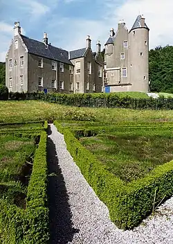
| |||
| Kelburn Sundial In Kitchen Garden | 55°46′20″N 4°50′48″W | Category B | 7299 | Upload Photo | |||
| Kelburn Bridge Over Kelburn Water Near Former Stable Block | 55°46′11″N 4°50′46″W | Category C(S) | 7300 | Upload Photo | |||
| Kelburn West Lodge And Gatepiers | 55°46′27″N 4°51′14″W | Category B | 7304 | Upload Photo | |||
| Skelmorlie, 5 Eglinton Terrace, Wilmar, With Garden Steps, Boundary Walls And Gatepiers | 55°51′51″N 4°53′11″W | Category C(S) | 50037 | Upload Photo | |||
| Skelmorlie, 12 Montgomerie Terrace, Oakhill With Garage, Boundary Wall, Gatepiers, Garden Terraces And Steps | 55°52′06″N 4°53′21″W | Category C(S) | 50044 | Upload Photo | |||
| Skelmorlie, 15 Shore Road, Thorndale, With Boundary Wall | 55°51′51″N 4°53′25″W | Category B | 50045 | Upload Photo | |||
| Skelmorlie, 10 Shore Road, Redesdale Including Former Service Wing, Boundary Wall And Gatepiers | 55°52′19″N 4°53′26″W | Category C(S) | 50046 | Upload Photo | |||
| Bankhead Farm | 55°48′42″N 4°52′35″W | Category C(S) | 37150 | Upload Photo | |||
| Bath Street/Promenade War Memorial | 55°47′32″N 4°52′17″W | Category C(S) | 37156 | Upload Photo | |||
| Greenock Road, Moorburn House | 55°47′56″N 4°52′03″W | Category B | 37166 | Upload Photo | |||
| Halkshill | 55°47′36″N 4°51′14″W | Category B | 37172 | Upload Photo | |||
| 33-45 Main Street Royal Bank Building (Odd Nos) | 55°47′39″N 4°52′07″W | Category B | 37183 | Upload Photo | |||
| 47 Main Street Mill Knitwear | 55°47′39″N 4°52′07″W | Category C(S) | 37184 | Upload Photo | |||
| 2 Nelson Street | 55°47′48″N 4°52′06″W | Category B | 37194 | Upload Photo | |||
| Skelmorlie Village 11 The Crescent The Birkenward | 55°52′06″N 4°53′09″W | Category B | 7283 | Upload Photo | |||
| Skelmorlie Village 3 Montgomery Terrace Manse And Gatepiers | 55°52′16″N 4°53′17″W | Category C(S) | 7287 | Upload Photo | |||
| Kelburn Gatepiers On South Drive (At A78) | 55°46′14″N 4°51′15″W | Category B | 7302 | Upload Photo | |||
| Knock Castle And Garden Pavilion Block And Gatepiers To East | 55°49′35″N 4°53′05″W | Category A | 7306 | Upload Photo | |||
| Brisbane Mains Meridian Pillar | 55°48′52″N 4°51′40″W | Category B | 7312 | Upload Photo | |||
| Fairlie Village Fairlie Castle | 55°45′15″N 4°50′58″W | Category B | 7315 | Upload Photo | |||
| Skelmorlie, 38 Montgomerie Terrace, Stroove With Boundary Walls, Gatepiers, Bridge, Waterfalls And Garden Steps | 55°51′58″N 4°53′21″W | Category C(S) | 49905 | Upload Photo | |||
| Skelmorlie, 4 Eglinton Terrace, Beechwood With Ancillary Building, Garden Terraces And Steps | 55°51′50″N 4°53′16″W | Category C(S) | 50039 | Upload Photo | |||
| Skelmorlie, 7 Montgomerie Terrace, The Beeches With Former Stable And Coach House, Garden Steps, Boundary Wall, Gates And Gatepiers | 55°52′13″N 4°53′17″W | Category C(S) | 50041 | Upload Photo | |||
| Skelmorlie, 11A Montgomerie Terrace With Ancillary Building | 55°52′09″N 4°53′16″W | Category C(S) | 50042 | Upload Photo | |||
| Skelmorlie, 13 Montgomerie Terrace And 16 And 16A Eglinton Gardens, Tigh Geal With Gates, Gatepiers, Boundary Wall, Garden Terrace, Steps And Drainage Channel | 55°52′05″N 4°53′17″W | Category B | 50043 | Upload Photo | |||
| 2-10 Bath Street (Even Nos) | 55°47′39″N 4°52′13″W | Category C(S) | 37154 | Upload Photo | |||
| 32, 34 Boyd Street | 55°47′46″N 4°52′00″W | Category C(S) | 37157 | Upload Photo | |||
| Broomfield Place/John St Elderslie Hotel (Building To South) And Gatepiers | 55°47′19″N 4°51′57″W | Category B | 37160 | Upload Photo | |||
| Greenock Road, Danefield House, Stables, Lodge And Gatepiers | 55°48′37″N 4°52′49″W | Category B | 37169 | Upload Photo | |||
| Kilbirnie Road, Cemetery Lodge And Walls | 55°47′07″N 4°51′15″W | Category B | 37176 | Upload Photo | |||
| Waterside Street "Three Sisters" Meridian Pillars | 55°47′38″N 4°51′40″W | Category B | 37197 | .jpg.webp)
| |||
| Knock Castle Stable Block And Gatepiers | 55°49′34″N 4°52′57″W | Category C(S) | 7274 | Upload Photo | |||
| The Crescent Croftmohr Lodge (Formerly Gardener's Cottage) | 55°52′01″N 4°53′11″W | Category C(S) | 7285 | Upload Photo | |||
| Skelmorlie Village Montgomery Terrace Craig Memorial Home And Gatepiers | 55°52′06″N 4°53′17″W | Category B | 7290 | Upload Photo | |||
| Fairlie Village Fairlie Village Hall | 55°45′24″N 4°51′16″W | Category B | 7293 | Upload Photo | |||
| Kelburn Gatepiers On Original Main West Drive (At A78) | 55°46′13″N 4°51′15″W | Category C(S) | 7303 | Upload Photo | |||
| 69, 71, 73 Nelson Street | 55°47′47″N 4°51′54″W | Category C(S) | 37192 | Upload Photo | |||
| Whittlieburn Bridge Over Noddsdale Water (On Constablewood Road) | 55°49′42″N 4°50′57″W | Category B | 7271 | Upload Photo | |||
| Brisbane Mains | 55°49′13″N 4°51′37″W | Category B | 7311 | Upload Photo | |||
| Skelmorlie, 1 Halketburn Road, Balvonie With Former Laundry And Former Stable / Coachhouse | 55°51′56″N 4°53′07″W | Category B | 50040 | Upload Photo | |||
| Gallowgate Street St Columba's Parish Church | 55°47′47″N 4°52′08″W | Category B | 37163 | 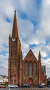
| |||
| 11 Gateside Street | 55°47′41″N 4°52′01″W | Category B | 37164 | Upload Photo | |||
| Harbour | 55°47′42″N 4°52′20″W | Category C(S) | 37174 | 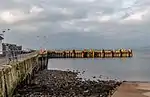
| |||
| 72, 74 Main Street | 55°47′37″N 4°52′07″W | Category B | 37186 | Upload Photo | |||
| 1 Makerston Place/1 Burnlea Road | 55°47′30″N 4°52′09″W | Category C(S) | 37187 | Upload Photo | |||
| 75 Nelson Street | 55°47′47″N 4°51′53″W | Category C(S) | 37193 | Upload Photo | |||
| Skelmorlie Village Skelmorlie Parish Church, Hall And Quadrant Wall | 55°52′19″N 4°53′24″W | Category B | 7269 | Upload Photo | |||
| Skelmorlie Village 9 The Crescent Tudor House And Gatepiers | 55°52′08″N 4°53′08″W | Category B | 7282 | Upload Photo | |||
| Kelburn Foot Former Lodge | 55°46′14″N 4°51′19″W | Category C(S) | 7305 | Upload Photo | |||
| Bridgend Old Bridge Over Skelmorlie Water | 55°51′01″N 4°53′08″W | Category B | 7310 | Upload Photo | |||
| 1 Anthony Road, Warriston | 55°47′08″N 4°51′42″W | Category B | 37147 | Upload Photo | |||
| Charles Street, Whitelodge Hotel (Formerly Blackdales) | 55°47′27″N 4°51′50″W | Category B | 37162 | Upload Photo | |||
| Largs Battle Monument ("The Pencil") | 55°46′45″N 4°51′34″W | Category B | 37177 | .jpg.webp)
| |||
| 5-11 Main Street (Odd Nos) | 55°47′41″N 4°52′11″W | Category C(S) | 37179 | Upload Photo | |||
| 20 Main Street Bank Of Scotland Building | 55°47′40″N 4°52′11″W | Category C(S) | 37185 | Upload Photo | |||
| Manor Park Hotel | 55°50′03″N 4°53′08″W | Category B | 7275 | Upload Photo | |||
| Noddsdale House Power House | 55°48′55″N 4°51′06″W | Category C(S) | 7278 | Upload Photo | |||
| St Phillans Lodge | 55°49′57″N 4°53′20″W | Category C(S) | 7280 | Upload Photo | |||
| Kelburn Gatepiers On North Drive (At A760) | 55°47′00″N 4°51′10″W | Category C(S) | 7301 | Upload Photo | |||
| Knock Old Castle | 55°49′38″N 4°53′09″W | Category B | 7307 | Upload Photo | |||
| Brisbane Mains Driveway Bridge Over Noddsdale Water | 55°49′05″N 4°51′22″W | Category C(S) | 7313 | Upload Photo | |||
| Fairlie Village Fairlie Parish Church | 55°45′38″N 4°51′17″W | Category B | 7317 | Upload Photo | |||
| Fairlie, 59 Main Road, Fairlie Lodge, Including Boundary Wall | 55°45′29″N 4°51′19″W | Category C(S) | 51722 | Upload Photo |
Key
The scheme for classifying buildings in Scotland is:
- Category A: "buildings of national or international importance, either architectural or historic; or fine, little-altered examples of some particular period, style or building type."[1]
- Category B: "buildings of regional or more than local importance; or major examples of some particular period, style or building type, which may have been altered."[1]
- Category C: "buildings of local importance; lesser examples of any period, style, or building type, as originally constructed or moderately altered; and simple traditional buildings which group well with other listed buildings."[1]
In March 2016 there were 47,288 listed buildings in Scotland. Of these, 8% were Category A, and 50% were Category B, with the remaining 42% being Category C.[2]
Notes
- Sometimes known as OSGB36, the grid reference (where provided) is based on the British national grid reference system used by the Ordnance Survey.
• "Guide to National Grid". Ordnance Survey. Retrieved 12 December 2007.
• "Get-a-map". Ordnance Survey. Retrieved 17 December 2007. - Historic Environment Scotland assign a unique alphanumeric identifier to each designated site in Scotland, for listed buildings this always begins with "LB", for example "LB12345".
References
- All entries, addresses and coordinates are based on data from Historic Scotland. This data falls under the Open Government Licence
- "What is Listing?". Historic Environment Scotland. Retrieved 29 May 2018.
- Scotland's Historic Environment Audit 2016 (PDF). Historic Environment Scotland and the Built Environment Forum Scotland. pp. 15–16. Retrieved 29 May 2018.
This article is issued from Wikipedia. The text is licensed under Creative Commons - Attribution - Sharealike. Additional terms may apply for the media files.