List of listed buildings in Latheron, Highland
List
| Name | Location | Date Listed | Grid Ref. [note 1] | Geo-coordinates | Notes | LB Number [note 2] | Image |
|---|---|---|---|---|---|---|---|
| Berriedale 2, Mill House | 58°11′01″N 3°29′59″W | Category C(S) | 7921 |  Upload Photo | |||
| Berriedale 1, 2, 3, Portland Terrace | 58°10′57″N 3°29′55″W | Category C(S) | 7923 | Upload Photo | |||
| Berriedale, The White House (Former Church Of Scotland Manse) | 58°11′10″N 3°29′54″W | Category C(S) | 7927 | Upload Photo | |||
| Latheron Post Office And Adjoining Terrace | 58°17′00″N 3°22′01″W | Category B | 7929 | Upload Photo | |||
| Dunbeath Castle, Walled Gardens and Garden Pavilion | 58°14′06″N 3°26′08″W | Category A | 7936 | 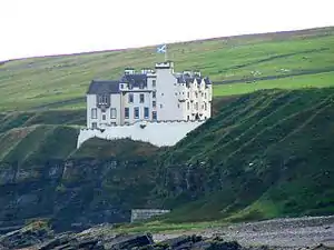
| |||
| Dunbeath, The Village (Macewen And Farquhar) | 58°14′58″N 3°25′53″W | Category C(S) | 7942 | Upload Photo | |||
| Gillivoan House | 58°17′19″N 3°22′10″W | Category B | 7950 | Upload Photo | |||
| Lybster Harbour Inver House | 58°17′50″N 3°17′32″W | Category B | 7956 | Upload Photo | |||
| Lybster Main Street (Grey Place) "Ornum" And G D Munro | 58°18′06″N 3°17′06″W | Category C(S) | 7961 | Upload Photo | |||
| Lybster Main Street (Grey Place) 2, 3, 6 Main Street (No 6 Gowanlea) And House Right Of Gowanlea | 58°18′09″N 3°17′05″W | Category C(S) | 7966 | Upload Photo | |||
| Lybster Quatre Bras C & A Ross Shop And Dwelling | 58°18′31″N 3°17′08″W | Category C(S) | 7998 | Upload Photo | |||
| Nottingham Mains Steading | 58°18′02″N 3°20′27″W | Category B | 8000 | Upload Photo | |||
| Berriedale Shore Cottages | 58°11′00″N 3°29′48″W | Category C(S) | 7924 | 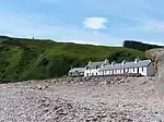
| |||
| Berriedale Shore, Fishing Store And Ice House | 58°10′59″N 3°29′51″W | Category C(S) | 7925 | Upload Photo | |||
| Berriedale Church Of Scotland And Burial Ground | 58°11′22″N 3°29′48″W | Category B | 7926 | .jpg.webp)
| |||
| Bridge Of Achavar, Over Clyth Burn | 58°19′06″N 3°15′37″W | Category C(S) | 7930 | 
| |||
| Braemore Lodge | 58°15′10″N 3°35′12″W | Category B | 7934 | 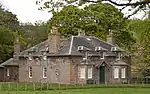
| |||
| Dunbeath Castle Gate Lodge And Gate Piers | 58°14′27″N 3°26′35″W | Category B | 7938 | Upload Photo | |||
| Forse House Gate Lodge And Gate Piers | 58°17′25″N 3°20′32″W | Category C(S) | 7948 | 
| |||
| Lybster Main Street (Grey Place) 2-4, 8 And 9 (No 9 "Shangri La") | 58°18′08″N 3°17′05″W | Category C(S) | 7967 | Upload Photo | |||
| Latheronwheel Bridge Over Burn Of Latheronwheel (On A9 Road) | 58°16′43″N 3°23′23″W | Category B | 7985 | 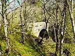
| |||
| Lybster Quatre Bras | 58°18′28″N 3°17′08″W | Category B | 7999 | Upload Photo | |||
| Latheron Former Schoolhouse, School And Walls | 58°17′01″N 3°22′00″W | Category B | 7928 | Upload Photo | |||
| Berriedale Pair Navigation Beacon Towers | 58°10′52″N 3°29′54″W | Category B | 7931 | .jpg.webp)
| |||
| The Corr | 58°18′10″N 3°21′45″W | Category A | 7935 | Upload Photo | |||
| Dunbeath The Village Mrs Mackay's House And Tigh A Mhuilinn (Lindsay) | 58°14′57″N 3°25′52″W | Category C(S) | 7941 | Upload Photo | |||
| Dunbeath, Portomin Harbour, Fishing Store And Ice House | 58°14′45″N 3°25′23″W | Category B | 7945 | Upload Photo | |||
| Lybster Harbour At Invershore | 58°17′45″N 3°17′29″W | Category B | 7954 | .jpg.webp)
| |||
| Lybster Main Street (West Side) Buchollie House | 58°17′57″N 3°17′04″W | Category C(S) | 7958 | Upload Photo | |||
| Lybster Main Street (West Side) The Yarrows And 3-7 (Inclusive Nos) Russell Street | 58°18′04″N 3°17′07″W | Category C(S) | 7960 | Upload Photo | |||
| Lybster Main Street (Grey Place) (East Side) Commercial Hotel | 58°18′09″N 3°17′05″W | Category C(S) | 7965 | 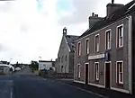
| |||
| Latheron Wheel (Janetstown) Craiglea | 58°16′35″N 3°23′06″W | Category C(S) | 7982 | Upload Photo | |||
| Buldoo Bell Tower | 58°17′08″N 3°21′44″W | Category B | 10950 | .jpg.webp)
| |||
| Swiney House | 58°17′46″N 3°18′23″W | Category B | 8003 | Upload Photo | |||
| Berriedale 1 Mill House | 58°11′01″N 3°30′00″W | Category C(S) | 7933 | Upload Photo | |||
| Dunbeath Hotel | 58°14′58″N 3°25′55″W | Category C(S) | 7944 | Upload Photo | |||
| Forse House Hotel | 58°17′59″N 3°20′41″W | Category B | 7946 | .jpg.webp)
| |||
| Forse House Hotel, Small House To Rear And Walled Garden | 58°18′00″N 3°20′38″W | Category B | 7947 | .jpg.webp)
| |||
| Lybster Ha' Store And Garden Walls | 58°18′33″N 3°16′34″W | Category C(S) | 7957 | Upload Photo | |||
| Lybster Main Street, (Grey Place) A H Sinclair Shop And Dwelling | 58°18′06″N 3°17′07″W | Category C(S) | 7962 | Upload Photo | |||
| Berriedale, 2 Bridges Over Berriedale And Langwell Waters | 58°11′03″N 3°30′05″W | Category C(S) | 7968 | Upload Photo | |||
| Berriedale War Memorial, Berriedale | 58°11′02″N 3°30′04″W | Category B | 7969 | .jpg.webp)
| |||
| Latheron Wheel House | 58°16′27″N 3°23′50″W | Category B | 7980 | Upload Photo | |||
| Lybster Main Street Craigard (L) And Milton (R) | 58°18′01″N 3°17′03″W | Category B | 7996 | Upload Photo | |||
| Dunbeath, Salmon Bothy | 58°14′42″N 3°25′17″W | Category B | 42894 | Upload Photo | |||
| Lybster, Main Street, (Grey's Place, East Side) Church Of Scotland, (St Mary's Church) | 58°18′10″N 3°17′05″W | Category B | 10951 | Upload Photo | |||
| Ousdale Farmhouse | 58°09′34″N 3°34′52″W | Category C(S) | 8002 | Upload Photo | |||
| Berriedale, Saw Mill | 58°11′01″N 3°29′57″W | Category B | 7922 | Upload Photo | |||
| Dunbeath Castle Dovecote | 58°14′29″N 3°26′40″W | Category B | 7939 | Upload Photo | |||
| Laidhay Croft Museum Croft House And Barn | 58°15′21″N 3°24′33″W | Category A | 7951 | 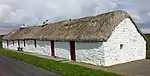
| |||
| Latheron Old Parish Church And Burial Ground | 58°16′53″N 3°21′43″W | Category B | 7952 | 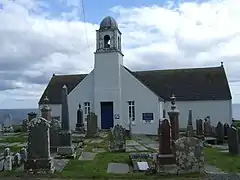
| |||
| Forse House Dovecote | 58°17′59″N 3°20′49″W | Category A | 7949 | Upload Photo | |||
| Lybster Harbour, Fishery Office | 58°17′48″N 3°17′32″W | Category C(S) | 7955 | Upload Photo | |||
| Latheronwheel, (Janetstown) Cooper's Buildings | 58°16′22″N 3°22′45″W | Category B | 7984 | Upload Photo | |||
| Berriedale, Welbeck Estate, Ivy Cottage And Laundry | 58°11′06″N 3°30′06″W | Category B | 50836 | Upload Photo | |||
| Berriedale, Welbeck Estate Office, Berriedale Post Office And Stable/Byre Range | 58°11′05″N 3°30′06″W | Category B | 7932 | Upload Photo | |||
| Dunbeath Castle, Stable Court | 58°14′11″N 3°26′22″W | Category B | 7937 | Upload Photo | |||
| Lybster Main Street, (Grey Place) Post Office And "Greymouth" | 58°18′07″N 3°17′07″W | Category C(S) | 7963 | Upload Photo | |||
| Latheronwheel (Janetstown) Barn/Store Immediately West Of Craiglea | 58°16′35″N 3°23′08″W | Category B | 7983 | Upload Photo | |||
| Latheronwheel (Janetstown) Harbour Bridge Over Burn Of Latheronwheel | 58°16′16″N 3°22′59″W | Category C(S) | 7986 | 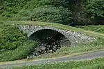
| |||
| Lybster Main Street (Grey Place) (East Side) Dwelling And Shop D Munro | 58°18′07″N 3°17′04″W | Category C(S) | 7995 | Upload Photo | |||
| Ousdale Bridge Over The Ousdale Burn | 58°09′43″N 3°35′22″W | Category C(S) | 8001 | 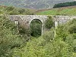
| |||
| Swiney, Miss Lillie's House | 58°18′03″N 3°18′28″W | Category C(S) | 8004 | Upload Photo | |||
| Dunbeath Bridge Over The Dunbeath Water (On A9 Road) | 58°14′58″N 3°25′58″W | Category B | 7940 | .jpg.webp)
| |||
| Dunbeath, The Village Murray M Smythe Shop | 58°14′58″N 3°25′54″W | Category C(S) | 7943 | Upload Photo | |||
| Latheron, Former Free Church Manse, Steading And Garden Walls | 58°17′04″N 3°22′08″W | Category C(S) | 7953 | Upload Photo | |||
| Lybster, Main Street, (West Side) Clydesdale Bank | 58°18′03″N 3°17′06″W | Category B | 7959 | .jpg.webp)
| |||
| Lybster Main Street (Grey Place) C Macdonald | 58°18′07″N 3°17′07″W | Category C(S) | 7964 | Upload Photo | |||
| Braemore Bridge Over The Berriedale Water | 58°15′10″N 3°34′54″W | Category B | 7970 | .jpg.webp)
| |||
| Latheron Wheel (Janets Town) Melbourne | 58°16′35″N 3°23′05″W | Category C(S) | 7981 | Upload Photo | |||
| Lybster Portland Arms | 58°18′30″N 3°17′11″W | Category C(S) | 7997 | .jpg.webp) |
Key
The scheme for classifying buildings in Scotland is:
- Category A: "buildings of national or international importance, either architectural or historic; or fine, little-altered examples of some particular period, style or building type."[1]
- Category B: "buildings of regional or more than local importance; or major examples of some particular period, style or building type, which may have been altered."[1]
- Category C: "buildings of local importance; lesser examples of any period, style, or building type, as originally constructed or moderately altered; and simple traditional buildings which group well with other listed buildings."[1]
In March 2016 there were 47,288 listed buildings in Scotland. Of these, 8% were Category A, and 50% were Category B, with the remaining 42% being Category C.[2]
See also
Notes
- Sometimes known as OSGB36, the grid reference (where provided) is based on the British national grid reference system used by the Ordnance Survey.
• "Guide to National Grid". Ordnance Survey. Retrieved 12 December 2007.
• "Get-a-map". Ordnance Survey. Retrieved 17 December 2007. - Historic Environment Scotland assign a unique alphanumeric identifier to each designated site in Scotland, for listed buildings this always begins with "LB", for example "LB12345".
References
- All entries, addresses and coordinates are based on data from Historic Scotland. This data falls under the Open Government Licence
- "What is Listing?". Historic Environment Scotland. Retrieved 29 May 2018.
- Scotland's Historic Environment Audit 2016 (PDF). Historic Environment Scotland and the Built Environment Forum Scotland. pp. 15–16. Retrieved 29 May 2018.
This article is issued from Wikipedia. The text is licensed under Creative Commons - Attribution - Sharealike. Additional terms may apply for the media files.