List of listed buildings in Lismore and Appin
List
| Name | Location | Date Listed | Grid Ref. [note 1] | Geo-coordinates | Notes | LB Number [note 2] | Image |
|---|---|---|---|---|---|---|---|
| Kentallen, Ardsheal House Gate Lodge | 56°39′59″N 5°15′17″W | Category B | 6878 |  Upload Photo | |||
| South Ballachulish, Ballachulish House Including Bothy, Walled Garden, Sundial, Boundary Walls And Gatepiers | 56°41′03″N 5°11′17″W | Category B | 6882 | Upload Photo | |||
| Glencoe Village, Bridge Of Coe Over River Coe | 56°41′01″N 5°05′50″W | Category B | 6893 | Upload Photo | |||
| Kinlochleven, Garbhein Road, Garbhein House | 56°42′44″N 4°58′30″W | Category C(S) | 46261 | Upload Photo | |||
| Kinlochleven, The Royal Bank Of Scotland, Leven Road | 56°42′47″N 4°57′59″W | Category C(S) | 46264 | Upload Photo | |||
| Kinlochleven, Road Viaduct At Leven Road | 56°42′48″N 4°58′15″W | Category A | 46265 | Upload Photo | |||
| Glencoe Village, Glencoe Hospital Gate Lodge | 56°41′02″N 5°05′46″W | Category C(S) | 6874 | Upload Photo | |||
| Keil Chapel And Burial Ground | 56°37′56″N 5°18′30″W | Category B | 6877 | Upload Photo | |||
| Glencoe, Achnacon House And Former Barn, The Leishman Centre | 56°39′50″N 5°04′17″W | Category C(S) | 6892 | Upload Photo | |||
| Kinlochleven Aluminium Works, Carbon Factory And Silos | 56°42′47″N 4°57′35″W | Category B | 12926 | Upload Photo | |||
| Kinlochleven Village Water Supply Dam (Near West Highland Way) | 56°41′54″N 4°56′53″W | Category B | 12928 | Upload Photo | |||
| Ballachulish Burial Ground Surrounding St John's Episcopal Church | 56°40′42″N 5°09′21″W | Category B | 6886 | .jpg.webp)
| |||
| Ballachulish, East Laroch, The Old Stables | 56°40′30″N 5°08′00″W | Category C(S) | 6888 | Upload Photo | |||
| Ballachulish Cnap An Tairbh, Loch Leven Slate Workers' Boat Houses | 56°40′39″N 5°08′40″W | Category C(S) | 48146 | Upload Photo | |||
| Duror, Acharn Barn | 56°38′35″N 5°15′55″W | Category B | 13444 | Upload Photo | |||
| Ballachulish Rudha Na Glas-Lice Loch Leven Slate Workers' Boat Houses | 56°40′47″N 5°07′57″W | Category B | 13307 | Upload Photo | |||
| Kinlochleven Bridge On Wade Road (West Highland Way) By Village Water Supply Dam | 56°41′56″N 4°56′53″W | Category B | 12927 | Upload Photo | |||
| Massacre of Glencoe Memorial, Glencoe Village | 56°40′56″N 5°05′42″W | Category C(S) | 6876 | .jpg.webp)
| |||
| Ballachulish, Episcopal Church Of St John | 56°40′41″N 5°09′21″W | Category C(S) | 6885 | 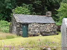
| |||
| Kinlochleven, Garbhein Road, Edenmhor | 56°42′43″N 4°58′25″W | Category C(S) | 46260 | Upload Photo | |||
| Kinlochleven, Garbhein Road, Inverleven | 56°42′44″N 4°58′18″W | Category C(S) | 46262 | Upload Photo | |||
| Etive Bridge On A82 | 56°39′06″N 4°51′08″W | Category B | 13486 | .jpg.webp)
| |||
| Ballachulish, Bridge Of Laroch Over River Laroch | 56°40′26″N 5°08′03″W | Category B | 6883 | 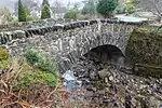
| |||
| Ballachulish, Church Of Scotland Church Of St Munda Brecklet | 56°40′22″N 5°07′55″W | Category C(S) | 6884 | Upload Photo | |||
| Duror, Episcopal Church Of St Adamnan | 56°38′55″N 5°16′19″W | Category C(S) | 6891 | Upload Photo | |||
| Glencoe Village, Episcopal Church Of St Mary And Former School Now Church Hall | 56°40′58″N 5°06′08″W | Category C(S) | 6871 | Upload Photo | |||
| Duror, Church Of Scotland Parish Church And Burial Ground | 56°38′47″N 5°16′26″W | Category B | 6889 | 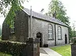
| |||
| Glencoe Village, Glencoe And North Lorn Folk Museum | 56°40′59″N 5°06′03″W | Category B | 6872 | Upload Photo | |||
| Glencoe Village, Glencoe Hospital | 56°41′13″N 5°05′59″W | Category B | 6873 | Upload Photo | |||
| Duror, Kulmony Former Duror Parish Manse | 56°38′45″N 5°16′23″W | Category C(S) | 6890 | Upload Photo | |||
| Kinlochleven, Garbhein Road, Tigh-Na-Bruaich | 56°42′43″N 4°58′21″W | Category C(S) | 46263 | Upload Photo | |||
| Kinlochleven, Power House | 56°42′47″N 4°57′29″W | Category A | 49944 | Upload Photo | |||
| Glencoe Village, Carnoch House (Carnoch Holiday And Outdoor Centre) | 56°41′04″N 5°06′06″W | Category C(S) | 6875 | Upload Photo | |||
| By Kentallen, Lagnaha Farmhouse | 56°39′22″N 5°15′34″W | Category C(S) | 6879 | Upload Photo | |||
| Achara House (By Duror) | 56°38′18″N 5°16′56″W | Category B | 6880 | Upload Photo | |||
| Ballachulish Hotel And Garden Walls (At South Ballachulish) | 56°41′15″N 5°11′04″W | Category B | 6881 | Upload Photo | |||
| Ballachulish, Former Episcopal Rectory | 56°40′42″N 5°09′27″W | Category B | 6887 | Upload Photo |
Key
The scheme for classifying buildings in Scotland is:
- Category A: "buildings of national or international importance, either architectural or historic; or fine, little-altered examples of some particular period, style or building type."[1]
- Category B: "buildings of regional or more than local importance; or major examples of some particular period, style or building type, which may have been altered."[1]
- Category C: "buildings of local importance; lesser examples of any period, style, or building type, as originally constructed or moderately altered; and simple traditional buildings which group well with other listed buildings."[1]
In March 2016 there were 47,288 listed buildings in Scotland. Of these, 8% were Category A, and 50% were Category B, with the remaining 42% being Category C.[2]
See also
Notes
- Sometimes known as OSGB36, the grid reference (where provided) is based on the British national grid reference system used by the Ordnance Survey.
• "Guide to National Grid". Ordnance Survey. Retrieved 12 December 2007.
• "Get-a-map". Ordnance Survey. Retrieved 17 December 2007. - Historic Environment Scotland assign a unique alphanumeric identifier to each designated site in Scotland, for listed buildings this always begins with "LB", for example "LB12345".
References
- All entries, addresses and coordinates are based on data from Historic Scotland. This data falls under the Open Government Licence
- "What is Listing?". Historic Environment Scotland. Retrieved 29 May 2018.
- Scotland's Historic Environment Audit 2016 (PDF). Historic Environment Scotland and the Built Environment Forum Scotland. pp. 15–16. Retrieved 29 May 2018.
This article is issued from Wikipedia. The text is licensed under Creative Commons - Attribution - Sharealike. Additional terms may apply for the media files.