List of listed buildings in Lochbroom, Highland
List
| Name | Location | Date Listed | Grid Ref. [note 1] | Geo-coordinates | Notes | LB Number [note 2] | Image |
|---|---|---|---|---|---|---|---|
| Ullapool Main Road, The Manse | Ullapool | 57°53′51″N 5°09′04″W | Category B | 7788 |  Upload Photo | ||
| Walled Garden, Dundonnel House | Dundonnell | 57°49′24″N 5°10′52″W | Category B | 7757 | Upload Photo | ||
| Lochbroom Parish Church (Church Of Scotland) and Burial Ground, Inverbroom | Inverbroom | 57°48′56″N 5°04′14″W | Category B | 7760 | 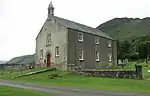
| ||
| Inverlael Farm (Formerly Lochbroom Post Office) | Inverlael | 57°49′34″N 5°03′52″W | Category B | 7762 | .jpg.webp)
| ||
| Inverlael Bridge Over River Lael | Inverlael | 57°49′18″N 5°03′47″W | Category B | 7763 | 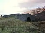
| ||
| Ullapool, 1, 2 Custom House Street, Drill Hall And House | Ullapool | 57°53′55″N 5°09′33″W | Category C(S) | 49788 | .jpg.webp)
| ||
| Ullapool Argyle Street Old Bank House | Ullapool | 57°53′47″N 5°09′31″W | Category B | 7785 | Upload Photo | ||
| Parish Church (Church Of Scotland), Old Mill Street | Ullapool | 57°53′54″N 5°09′24″W | Category C(S) | 7789 | 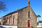
| ||
| Ullapool Old Mill Street, Hill Cottage And Rear Byre Range | Ullapool | 57°53′58″N 5°09′12″W | Category C(S) | 7790 | Upload Photo | ||
| Corrieshalloch Gorge, Suspension Footbridge Over Measach Falls | Braemore | 57°45′21″N 5°01′16″W | Category B | 7755 | 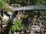
| ||
| Dundonnell House | Dundonnell | 57°49′23″N 5°10′48″W | Category B | 7756 | 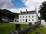
| ||
| Fowler Memorial Clock, Quay Street | Ullapool | 57°53′46″N 5°09′37″W | Category B | 7791 | 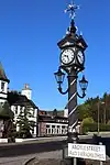
| ||
| Garden Cottage/Guest House, Dundonnel House | Dundonnell | 57°49′23″N 5°10′55″W | Category C(S) | 7758 | Upload Photo | ||
| Caledonian Macbrayne and Tourist Office, West Shore Street | Ullapool | 57°53′43″N 5°09′39″W | Category C(S) | 7765 | 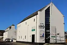
| ||
| Isle Martin, Macleod's House | Isle Martin | 57°56′22″N 5°13′03″W | Category C(S) | 50859 | _(cropped).jpg.webp)
| ||
| Ullapool 4 (L) And 5 (R) Custom House Street | Ullapool | 57°53′55″N 5°09′30″W | Category C(S) | 7786 | 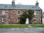
| ||
| Ice House, Braemore House | Braemore | 57°45′58″N 5°01′29″W | Category B | 13315 | Upload Photo | ||
| The Captain's Cabin, Quay Street | Ullapool | 57°53′45″N 5°09′35″W | Category B | 7792 | 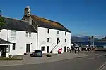
| ||
| Footbridge Over Abhainn Cuileig, Braemore Estate | Braemore | 57°45′09″N 5°03′00″W | Category B | 13316 | .jpg.webp)
| ||
| Auchindrean Bridge, Over River Broom | Braemore | 57°46′43″N 5°02′11″W | Category A | 7754 | .jpg.webp)
| ||
| Ullapool Argyle Street Former Ullapool Parish Church And Burial Ground | Ullapool | 57°53′45″N 5°09′44″W | Category A | 7764 | 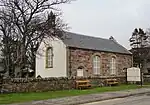
| ||
| Ullapool, West Shore Street, Ornsay House | Ullapool | 57°53′43″N 5°09′40″W | Category C(S) | 7787 | Upload Photo | ||
| Garden Ballroom, Dundonnel House | Dundonnell | 57°49′23″N 5°10′48″W | Category B | 7759 | Upload Photo | ||
| Fishing Station and Quay | Tanera Mòr | 58°00′36″N 5°24′15″W | Category B | 7766 | .jpg.webp)
| ||
| Achiltibuie Former Mill | Achiltibuie | 58°01′35″N 5°21′24″W | Category C(S) | 7753 | Upload Photo | ||
| Inverbroom Glenview (Former Church Of Scotland Parish Manse) | Inverbroom | 57°48′56″N 5°04′21″W | Category C(S) | 7761 | Upload Photo |
Key
The scheme for classifying buildings in Scotland is:
- Category A: "buildings of national or international importance, either architectural or historic; or fine, little-altered examples of some particular period, style or building type."[1]
- Category B: "buildings of regional or more than local importance; or major examples of some particular period, style or building type, which may have been altered."[1]
- Category C: "buildings of local importance; lesser examples of any period, style, or building type, as originally constructed or moderately altered; and simple traditional buildings which group well with other listed buildings."[1]
In March 2016 there were 47,288 listed buildings in Scotland. Of these, 8% were Category A, and 50% were Category B, with the remaining 42% being Category C.[2]
See also
Notes
- Sometimes known as OSGB36, the grid reference (where provided) is based on the British national grid reference system used by the Ordnance Survey.
• "Guide to National Grid". Ordnance Survey. Retrieved 12 December 2007.
• "Get-a-map". Ordnance Survey. Retrieved 17 December 2007. - Historic Environment Scotland assign a unique alphanumeric identifier to each designated site in Scotland, for listed buildings this always begins with "LB", for example "LB12345".
References
- All entries, addresses and coordinates are based on data from Historic Scotland. This data falls under the Open Government Licence
- "What is Listing?". Historic Environment Scotland. Retrieved 29 May 2018.
- Scotland's Historic Environment Audit 2016 (PDF). Historic Environment Scotland and the Built Environment Forum Scotland. pp. 15–16. Retrieved 29 May 2018.
This article is issued from Wikipedia. The text is licensed under Creative Commons - Attribution - Sharealike. Additional terms may apply for the media files.